|
|

|
|
Freezing HillAncient Village / Settlement / Misc. Earthwork
|
||||||||||||||||||||||||
|
|
|
Images (click to view fullsize) |
|
|
Miscellaneous |
|
|
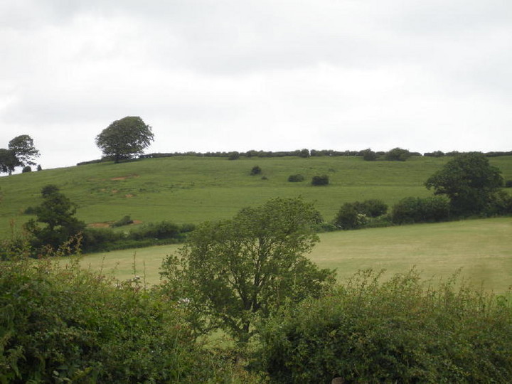
Details of earthwork on Pastscape A possible Iron Age linear earthwork on Freezing Hill, known as Royal Camp or Old Dyke in the past. (Extends from ST 7200 7148 to ST 7233 7102) Camp (NR) (1) Some earthworks on the southern side of Freezing or Furzen Hill consist of a bank with a ditch on either side. It has been suggested that they formed part of a civil boundary connected with the earthworks on Tog Hill. (ST 77 SW 90). (2) An earthwork, possibly a linear dyke of Iron Age date, extends for about 1800 ft along the SW side of Freezing Hill. It is called "Old Dyke" in Saxon charters, and "Royal Camp" on Isaac Taylor's map of 1777. The bank, 24ft wide and 2ft high, stands on the edge of the escarpment, and the ditch, also 24ft wide, lies 9ft below. At either end the dyke terminates at hollow-ways leading down the slope. It is interrupted only at the parish boundary where bank and ditch are cut by a deep hollow-way and over-ridden by an associated boundary bank. Neither the internal ditch mentioned by Playne and Witts nor the NE extensions of the dyke shown on Witts' map, can be traced. (3) Published 1:2500 survey correct. (4) Freezing Hill Earthwork, scheduled. (5) |
 Posted by Chance
14th October 2012ce |
|
Freezing Hill, took some photos the other day of the lynchets that lie to the east and south of this maybe defended enclosure but no inner bank It is mentioned as a hillfort in Iron Age southern map, (1960) but not scheduled on Magic.. The barrow is at ST722.715. There seems to be a pattern of settlement around these forts/enclosures that needs to be explored. Its on private land, with lots of frisky bullocks around at the moment. Edit;This site, is in many ways similar to Hinton Hillfort. A promontory hillfort, but in this instance guarding two valleys down from the Cotswold; a distinctive territorial barrier also perhaps. As Wick burial chamber is not too faraway, neolithic finds round this area would be expected (Rhiannon's post). Freorig = cold chill,(freosan - freezing) Anglo saxon. |
 Posted by moss
13th July 2006ce Edited 30th April 2007ce |
|
The earthworks on Freezing Hill are quite visible from afar - they seem to defend the steep south west slope of the flattish topped hill. The 'Magic' record is not yet online, so doesn't come up with any details to confirm a prehistoric date, but there is a barrow (at least on the map) above the north western slope. According to Mark Richards' "The Cotswold Way" (1984) the earthwork is called 'eald dic' in a Saxon charter (so one assumes it is pre-Saxon if they thought it was old). He suggests 'freezing hill' comes from 'Frisian's Hill' - Frisa being a OE nickname. Moss speculates it may come from 'Frey(a)': http://www.themodernantiquarian.com/post/31851 Isaac Taylor raised its status on his 1777 map of Gloucestershire, on which he labelled it 'Royal Camp'. George Witts (c1882) gives 'Furzen Hill' as an alternative name (which is quite a boring explanation) but could be based on local pronunciation of freezing? And I'm sure it is freezing up there at the moment. A prehistoric sandstone axe was found here at some time, as you can read at http://ads.ahds.ac.uk/catalogue/search/fr.cfm?rcn=SGLOSSMR-SG2428&CFID=392636&CFTOKEN=45832204 |
 Posted by Rhiannon
24th February 2006ce Edited 23rd October 2006ce |