The Modern Antiquarian
Log in
|
Register
Home
Latest Posts
Forums
Maps
Help
Browse Sites
News
Blog
Contributors
The Books
Select
-
Belgium
Denmark
Eire
France
Germany
Greece
Italy
The Netherlands
Norway
Portugal
Republic of Malta
Spain
Sweden
Switzerland
United Kingdom
England
Northern England
Lancashire
Round Hill
Ancient Village / Settlement / Misc. Earthwork
Round Hill (Ancient Village / Settlement / Misc. Earthwork) on The Modern Antiquarian, the UK & Ireland's most popular megalithic community website. 2 images, 1 fieldnote, plus information on many more ancient sites nearby and across the UK & Ireland.
Image © treehugger-uk
Nearest Town:
Burnley (4km WNW)
OS Ref (GB):
SD876307 /
Sheet: 103
Latitude:
53° 46' 19.85" N
Longitude:
2° 11' 17.38" W
Added by
treehugger-uk
Images (2)
Fieldnotes (1)
0 discussions
Start a topic
Show |
Hide
Web searches for Round Hill
Flickr
Google
Google Images
MAGIC
The Megalithic Portal
Bing
Stone Pages
Streetmap.co.uk
Wikipedia
Show map
(inline Google Map)
- Sites within 20 km -
-
Stump Cross (0.61km SSE) (6 posts)
Cliviger Law (0.64km SW) (4 posts)
Mosley Height (0.71km ESE) (10 posts)
Worsthorne Hill (2.37km NNE) (9 posts)
Hambledon Pasture (2.42km NE) (13 posts)
Ring Stones (2.5km NNE) (8 posts)
Cant Clough (3.03km ENE) (2 posts)
Twist Castle & Barrow (3.26km NNE) (6 posts)
Beadle Hill (3.73km NNE) (1 post)
Delf Hill (3.9km NE) (19 posts)
Pike Lowe (4.06km NNE) (2 posts)
Ell Clough (4.21km NE) (5 posts)
Hellclough (4.27km NE) (11 posts)
Extwistle Moor (4.35km NE) (5 posts)
Burwains Camp (5.19km NNE) (10 posts)
Burwain's Farm (5.23km N) (0 posts)
Ring Stones Hill (6.2km NNE) (1 post)
Great Bride Stones (6.81km E) (16 posts)
Dove Stones (7.03km ENE) (3 posts)
Sutcliffe Rough Standing Stone (7.26km ENE) (4 posts)
Standing Stone Hill (7.39km E) (3 posts)
Castercliff Camp (7.73km N) (16 posts)
Little Hameldon (8.29km WSW) (12 posts)
Blackheath Circle (8.46km ESE) (1 post)
The Stones (8.53km ESE) (13 posts)
Blackheath Barrow (8.58km ESE) (0 posts)
Hippins Stone (9.11km E) (1 post)
Walshaw Dean (9.3km ENE) (18 posts)
Bent Head (9.65km E) (4 posts)
Wycoller Hall (10.24km NE) (5 posts)
Silver Hill (12.47km ENE) (1 post)
Thirteen Stones Hill (12.69km WSW) (8 posts)
Pendle Hill (12.87km WNW) (11 posts)
Jeppe Knave Grave (13.56km W) (10 posts)
Two Lads (Withens Moor) (13.77km ESE) (3 posts)
Portfield Hillfort (13.81km W) (4 posts)
Midgley Moor Standing Stone (14.14km E) (4 posts)
Wicken Hill (14.14km E) (2 posts)
Higher House Moor Monolith (14.15km ESE) (1 post)
Robin Hood's Penny Stone (14.34km E) (6 posts)
Miller's Grave (14.43km E) (5 posts)
Churn Milk Joan (14.58km E) (9 posts)
Turley Holes Moor Standing Stones (14.88km ESE) (3 posts)
Bleara Lowe (15.51km NNE) (5 posts)
Winter Hill Stone (15.53km NE) (1 post)
Hitching Stone (Keighley Moor) (15.59km NE) (4 posts)
Rocking Stone, Warley Moor (15.66km E) (1 post)
Worsaw Hill (15.79km WNW) (0 posts)
Whitelow (16.12km SSW) (10 posts)
Rectory Allotment (17.69km NNE) (6 posts)
Loe Hill (17.99km W) (7 posts)
Winckley Lowes (18.16km W) (8 posts)
Castlestead Ring (18.41km ENE) (2 posts)
Brock Hall Tumulus (18.9km W) (1 post)
Carve Hill (19.22km SW) (4 posts)
All Hallows Well (19.34km WSW) (1 post)
Castlesteads (19.35km SSW) (9 posts)
Cross Gills Mound (19.38km W) (4 posts)
- Facilities within 20 km -
-
middle beardshaw head ... (Camping Site: 7.9 km N)
Fox and Goose (Pub: 11.5 km E)
- Add -
-
Add news
Add an image
Add fieldnotes
Add folklore
Add miscellaneous
Add a link
-
Add a site
Add a nearby facility
Add an alternative name/spelling
Images
(click to view fullsize)
Add an image
Fieldnotes
Add fieldnotes
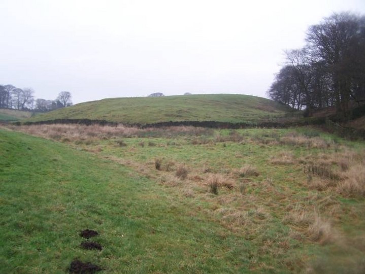
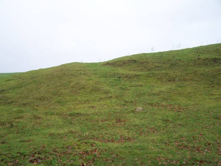
This site is simply marked as an earthwork on Maps. On closer inspection it looks like a small hilltop settlement and there are a few of these around Lancs. that are quite similliar. Theres also rumoured to be a carved stone close by.
This post appears as part of the weblog entry
Yule Be Disappointed
Comments (0)
|
Add a comment
|
Permalink
Posted by
treehugger-uk
3rd January 2006ce
Edited 4th January 2006ce

 Posted by treehugger-uk