The Modern Antiquarian
Log in
|
Register
Home
Latest Posts
Forums
Maps
Help
Browse Sites
News
Blog
Contributors
The Books
Select
-
Belgium
Denmark
Eire
France
Germany
Greece
Italy
The Netherlands
Norway
Portugal
Republic of Malta
Spain
Sweden
Switzerland
United Kingdom
Scotland
Orkney
East Mainland
Hillhead
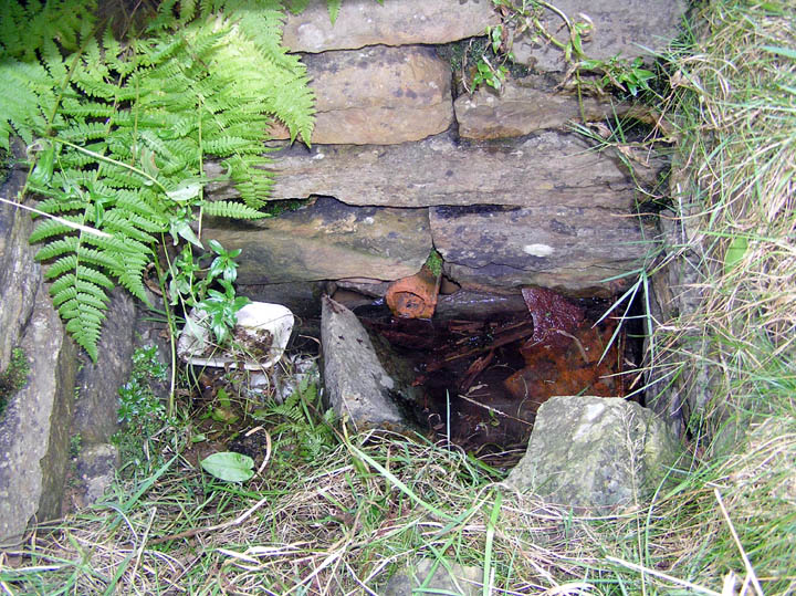
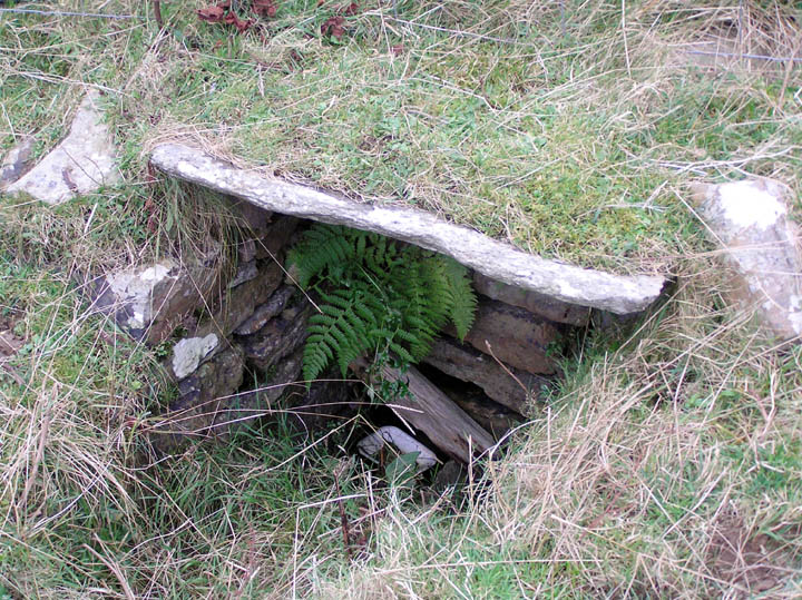
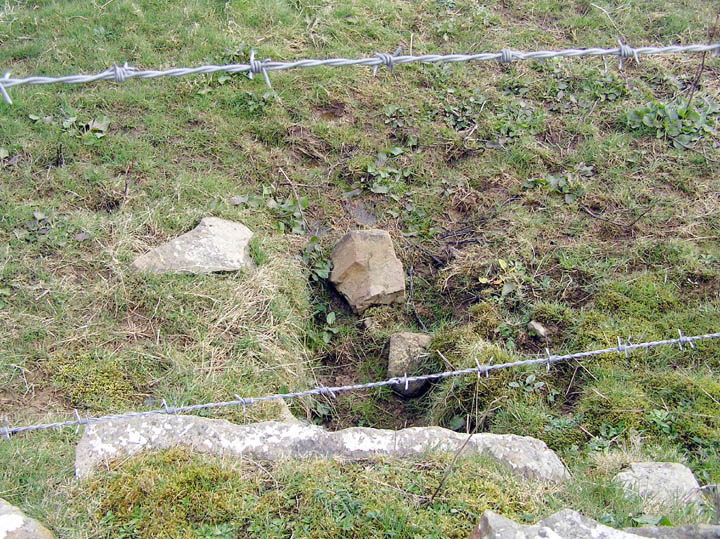
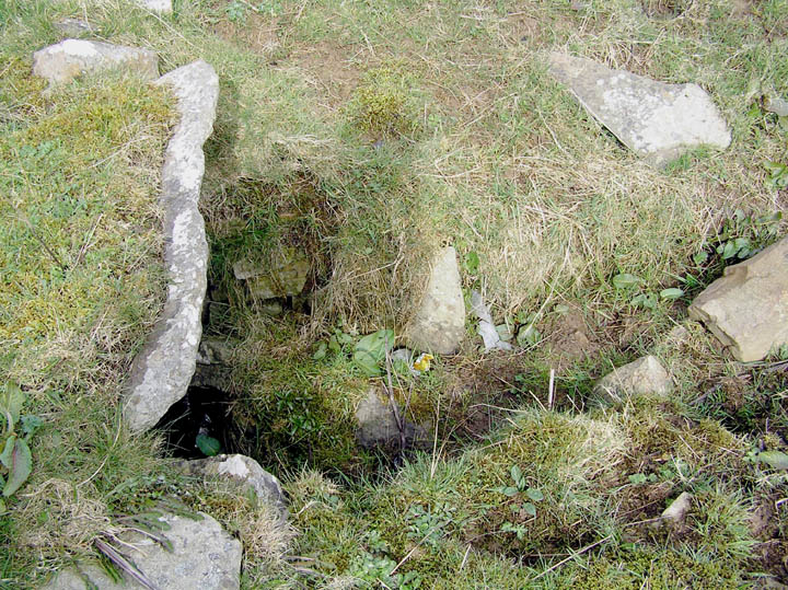
Hillhead Well
Hillhead Well on The Modern Antiquarian, the UK & Ireland's most popular megalithic community website. 4 images, plus information on many more ancient sites nearby and across the UK & Ireland.
Image © wideford
This site is of disputed antiquity. If you have any information that could help clarify this site's authenticity, please post below or
leave a post in the forum
.
Nearest Town:
Kirkwall (2km NNE)
OS Ref (GB):
HY447086 /
Sheets: 6, 7
Latitude:
58° 57' 40.44" N
Longitude:
2° 57' 41.66" W
Added by
TMA Ed
Images (4)
0 discussions
Start a topic
Show |
Hide
Web searches for Hillhead Well
Flickr
Google
Google Images
MAGIC
The Megalithic Portal
Bing
Stone Pages
Streetmap.co.uk
Wikipedia
Show map
(inline Google Map)
- Sites within 20 km -
-
Hillhead Enclosure (0.1km SSE) (21 posts)
Scapa (0.4km NNW) (5 posts)
Nether Crantit (0.67km W) (6 posts)
Crantit (0.8km W) (22 posts)
Broch of Lingro (1.21km W) (25 posts)
Lingrow (1.49km WSW) (10 posts)
Pickaquoy (2.66km NW) (10 posts)
Grain Souterrain (3.04km NNW) (31 posts)
Berstane Broch (3.15km ENE) (10 posts)
The Five Hillocks (3.48km SE) (8 posts)
Howe of Staneloof (3.83km E) (1 post)
Staneloof (3.96km E) (4 posts)
Ston Loe (4.02km E) (3 posts)
Wideford (4.35km WNW) (8 posts)
Saverock (4.36km NW) (11 posts)
Saverock (4.5km NW) (15 posts)
Craw Howe (4.7km E) (5 posts)
The Five Hillocks (4.96km E) (9 posts)
Crossiecrown (5.14km NW) (3 posts)
Wideford Hill (5.15km WNW) (52 posts)
Quanterness (5.23km WNW) (9 posts)
Wideford Hill (5.23km WNW) (10 posts)
Yinstay (6.28km ENE) (1 post)
Long Cairn (6.31km NE) (62 posts)
Rennibister (6.32km W) (42 posts)
Nearhouse (6.34km E) (4 posts)
Whitecleat (6.38km E) (6 posts)
Nabban (6.43km W) (7 posts)
Burn of Langskaill (6.56km E) (3 posts)
Round Howe (6.63km E) (12 posts)
Long Howe (6.7km E) (15 posts)
The Howie of The Manse (6.71km ENE) (5 posts)
Hawell (6.84km E) (7 posts)
Mine Howe (6.94km E) (51 posts)
Laughton's Knowe (6.98km ESE) (6 posts)
Hall of Gorn (7.01km ESE) (6 posts)
Ingshowe Broch (7.06km W) (21 posts)
Mecigar (7.23km E) (4 posts)
Loch of Tankerness (7.49km ENE) (17 posts)
St. Mary's Broch (7.54km SE) (8 posts)
Twi Ness (7.91km NNE) (5 posts)
Setter Noost (8.04km NNE) (13 posts)
Tower of Clett (8.42km ESE) (8 posts)
Lamb Holm (8.88km SE) (14 posts)
Chapel Knowe (9.09km WNW) (3 posts)
The Fairy Knowe (9.23km W) (71 posts)
Graystane (9.23km WSW) (8 posts)
Venikelday (9.23km E) (11 posts)
Broch of Steiro (9.41km NE) (22 posts)
Howe Hill (9.8km NE) (6 posts)
St. Peter's Bay (9.84km E) (11 posts)
The Brough (9.88km ENE) (3 posts)
St Peter's Kirk (9.96km E) (7 posts)
Hillock of Breakna (9.99km WSW) (14 posts)
Hurnip's Point (10km E) (9 posts)
Toy Ness (10.03km WSW) (12 posts)
St. Nicholas Church (10.12km ESE) (1 post)
The Hillock (10.23km W) (18 posts)
Comely (10.34km E) (4 posts)
Eves Howe (10.46km E) (7 posts)
Castle Howe (10.63km ESE) (9 posts)
Rowamo Cottage (10.68km W) (4 posts)
Konger's Knowe (10.75km WSW) (18 posts)
Oyce of Isbister (10.97km WNW) (4 posts)
The Cairn (11.1km E) (5 posts)
Ward Hill (11.13km WSW) (4 posts)
St Mary's Kirk (Isbister) (11.14km NW) (8 posts)
Mor Stein (11.22km NE) (11 posts)
Snaba Hill (11.25km W) (6 posts)
Stembister (11.25km E) (12 posts)
Hill of Heddle (11.28km W) (2 posts)
Dingieshowe (11.33km E) (10 posts)
Gyre (11.35km WSW) (4 posts)
Knowe of Dishero (11.56km NNW) (15 posts)
Howe Harper (11.56km W) (16 posts)
Sandyhall (11.79km NW) (6 posts)
Castle Bloody (11.81km NE) (6 posts)
Wasdale (12.02km W) (42 posts)
Millfield (12.09km E) (5 posts)
North Howe (12.29km ESE) (11 posts)
Harproo (12.31km WSW) (8 posts)
Lower Hobbister (12.33km W) (8 posts)
South Howe (12.34km ESE) (18 posts)
The Cairnhead, Hunda (12.48km S) (5 posts)
Howan Blo (12.62km E) (4 posts)
Mussaquoy (12.83km E) (14 posts)
Southtown (Burray), St Lawrence Church (12.95km SE) (13 posts)
Seven Knowes (13.25km NW) (10 posts)
Dale (13.4km W) (7 posts)
Newark (13.47km E) (7 posts)
Maeshowe (13.49km W) (88 posts)
Unyatuak (13.52km NE) (9 posts)
Knowes of Trotty (13.8km WNW) (14 posts)
Barnhouse Stone (13.82km W) (12 posts)
Backland (14.05km E) (6 posts)
Vola (14.21km W) (18 posts)
Harraymen's Graves (14.22km WNW) (1 post)
Appiehouse (14.24km W) (12 posts)
Henge (14.32km W) (3 posts)
Pickaquoy (14.32km W) (6 posts)
Barnhouse Settlement (14.44km W) (64 posts)
Riggan of Kami (14.46km E) (14 posts)
The Standing Stones of Stenness (14.48km W) (125 posts)
Staney Hill (14.53km W) (20 posts)
Stone of Odin (14.53km W) (14 posts)
The Watchstone (14.6km W) (27 posts)
Feolquoy (14.67km W) (4 posts)
Standing Stones Hotel (14.67km W) (6 posts)
Grimston (14.69km W) (10 posts)
Little Howe of Hoxa (14.71km S) (20 posts)
Howe of Hoxa (14.73km S) (19 posts)
Harray Viewpoint (14.77km W) (8 posts)
Tingwall (14.89km NW) (28 posts)
Nether Bigging (14.91km W) (2 posts)
Lochview (14.94km W) (31 posts)
Staney Hill (14.95km W) (22 posts)
Ness of Brodgar (14.97km W) (49 posts)
Lyde Road (15.07km W) (1 post)
The Wart (15.13km S) (15 posts)
Nettletar (15.15km W) (8 posts)
Hillock of Burroughston (15.32km NE) (14 posts)
Sower (15.43km WSW) (7 posts)
Maesquoy (15.67km W) (2 posts)
Comet Stone (15.73km W) (36 posts)
Knowe of Midgarth (15.75km NW) (12 posts)
Fresh Knowe (15.79km W) (13 posts)
Ness of Brodgar Cairns (15.79km W) (1 post)
Plumcake Mound (15.91km W) (9 posts)
Knowe of Gullow (15.93km W) (4 posts)
Ring of Brodgar (15.98km W) (186 posts)
Salt Knowe (16.04km W) (14 posts)
Knowe of Burrian (Garth Farm) (16.07km W) (4 posts)
Corn Hillock (16.23km W) (8 posts)
Burrian (Corrigall) (16.32km WNW) (8 posts)
Cummi Howe (16.49km W) (17 posts)
Wasbister Disc Barrow (16.54km W) (17 posts)
Bookan Cairns (16.6km W) (25 posts)
Unstan (16.63km W) (78 posts)
Wasbister Cairn (16.71km W) (10 posts)
Point of Onston (16.73km W) (4 posts)
Ness of Woodwick (16.88km NW) (12 posts)
Bookan (16.92km W) (20 posts)
The Brecks (17.02km W) (56 posts)
Burrian Broch (17.14km W) (2 posts)
The Howe (17.19km W) (12 posts)
The Howe (17.19km W) (5 posts)
The Howe (17.19km W) (4 posts)
Ring of Bookan (17.27km W) (24 posts)
Sorquoy (17.3km SSE) (16 posts)
Skae Frue (17.43km W) (15 posts)
Kirk Ness (17.46km SSE) (1 post)
Kirk Ness Mound (17.46km SSE) (4 posts)
Redland South (17.53km NW) (16 posts)
Kirk Ness Dyke (17.57km SSE) (2 posts)
Redland North (17.69km NW) (1 post)
Deepdale (17.74km W) (21 posts)
Quoys (17.81km NW) (1 post)
Burrian (Russland) (17.88km W) (5 posts)
North Biggin (17.92km W) (12 posts)
Kirkhouse Cairn (17.94km SSE) (4 posts)
Quoyelsh (18.13km WSW) (11 posts)
Shennar Howe (18.41km W) (2 posts)
Stackrue-Lyking Mound (18.69km W) (6 posts)
Stackrue Broch (18.79km W) (22 posts)
Knowe of Hunclett (18.86km NNW) (7 posts)
Clouduhall (19km S) (6 posts)
Rosemount and Easthouse (19.04km W) (1 post)
Taversoe Tuick (19.08km NNW) (51 posts)
Clouduhall (19.1km S) (15 posts)
Hourston (19.18km W) (5 posts)
Blackhammer (19.24km NNW) (27 posts)
Broch of Gurness (19.28km NW) (47 posts)
Long Stone (19.34km NW) (11 posts)
Knowe of Burrian (19.37km NW) (6 posts)
Cubbie Roo's Burden (19.38km NNW) (6 posts)
Linga Fold (19.42km W) (1 post)
Voy (19.6km W) (29 posts)
Dounby House (19.64km W) (1 post)
Stews (19.65km SSE) (5 posts)
Knowe of Makerhouse (19.7km W) (2 posts)
Knowe of Yarso (19.71km NW) (33 posts)
East House (19.77km W) (1 post)
Knowe of Lairo (19.87km NW) (19 posts)
Knowe of Stenso (19.91km NW) (13 posts)
Knowe of Ramsay (19.99km NW) (4 posts)
- Facilities within 20 km -
-
Kirkwall Youth Hostel (Youth Hostel: 1.7 km NNW)
The Kirkwall Hotel (Hotel: 2.5 km N)
Tankerness House Museum (Museum: 2.5 km N)
Atlantis Lodges (Holiday Cottage: 9.5 km WNW)
Tormiston Mill (Cafe: 12.5 km W)
Shapinsay Heritage Centre (Museum: 14.1 km NNE)
Balfour Castle (Hotel: 14.1 km NNE)
Lochend (Holiday Cottage: 14.5 km W)
Mill of Eyrland (Bed & Breakfast: 14.9 km W)
Point of NessCaravan a... (Camping Site: 19.1 km WSW)
Browns Hostel (Stromness) (Youth Hostel: 19.3 km W)
Stromness Youth Hostel (Youth Hostel: 19.5 km W)
- Add -
-
Add news
Add an image
Add fieldnotes
Add folklore
Add miscellaneous
Add a link
-
Add a site
Add a nearby facility
Add an alternative name/spelling
Images
(click to view fullsize)
Add an image