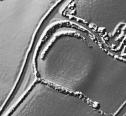
The Modern Antiquarian
Log in
|
Register
Home
Latest Posts
Forums
Maps
Help
Browse Sites
News
Blog
Contributors
The Books
Select
-
Belgium
Denmark
Eire
France
Germany
Greece
Italy
The Netherlands
Norway
Portugal
Republic of Malta
Spain
Sweden
Switzerland
United Kingdom
England
Southern England
Cornwall
Dingerein Castle
Hillfort
Dingerein Castle (Hillfort) on The Modern Antiquarian, the UK & Ireland's most popular megalithic community website. 1 image, 1 piece of folklore, plus information on many more ancient sites nearby and across the UK & Ireland.
Image © © Environment Agency copyright and/or database right 2015.
Nearest Town:
Falmouth (8km SW)
OS Ref (GB):
SW882375 /
Sheet: 204
Latitude:
50° 11' 56.11" N
Longitude:
4° 58' 5.23" W
Added by
phil
Images (1)
Folklore (1)
0 discussions
Start a topic
Show |
Hide
Web searches for Dingerein Castle
Flickr
Google
Google Images
MAGIC
The Megalithic Portal
Bing
Stone Pages
Streetmap.co.uk
Wikipedia
Show map
(inline Google Map)
- Sites within 20 km -
-
Veryan Castle (2.99km ENE) (9 posts)
Carne Beacon (3.28km ENE) (11 posts)
Round Wood (5.34km W) (2 posts)
Cregou Barrow (6.71km NW) (2 posts)
Cuby Stone (8.99km NNE) (1 post)
Golden Hillfort (10.28km NNE) (4 posts)
Carvossa Enclosure (11.4km NNE) (2 posts)
Dodman Point (12.08km ENE) (5 posts)
Bishop's Wood (Truro) (12.37km NW) (3 posts)
Stithians Menhir (13.27km WSW) (5 posts)
Mabe Church (13.45km WSW) (13 posts)
Higher Spargo (13.94km WSW) (2 posts)
Allet (14km WNW) (1 post)
Little Regarded Farm (14.53km WNW) (1 post)
Pabyer Point (14.83km ENE) (2 posts)
Eathorne Menhir (14.9km WSW) (7 posts)
Tresawsen (15.09km WNW) (1 post)
Little Dennis (15.14km SW) (9 posts)
Trebowland Round (15.29km W) (2 posts)
Callestick Vean (15.71km WNW) (1 post)
Tolmen Stone (Constantine) (15.79km WSW) (9 posts)
Four Burrows (16.1km WNW) (6 posts)
Hendra Farm (16.17km NNW) (1 post)
Three Burrows (16.29km WNW) (2 posts)
Stithians Cupmarked Stones (16.57km WSW) (5 posts)
Carland Cross Burrows (16.79km NW) (3 posts)
Mitchell Farm (16.9km NNW) (1 post)
Carvannel Menhir (16.98km W) (6 posts)
Pendown (16.98km WNW) (1 post)
Trewardreva Fogou (17.07km WSW) (26 posts)
Callestick (17.18km WNW) (1 post)
Two Burrows (17.38km W) (1 post)
Roskruge Beacon (17.62km SW) (0 posts)
Giants Quoits (17.82km SSW) (7 posts)
Higher Boden Roundhouse (17.83km SW) (1 post)
Higher Boden Fogou (17.83km SW) (8 posts)
Caer Keif (17.94km WNW) (3 posts)
Caer Dane (17.97km WNW) (6 posts)
Castle Gotha Settlement (18.38km NE) (2 posts)
Carnmenellis (18.66km WSW) (7 posts)
Four Lanes barrows (18.75km W) (4 posts)
Black Head (18.78km NE) (6 posts)
Rosehill Farm (19.1km NW) (1 post)
Calvadnack Settlement (19.23km WSW) (1 post)
Tremenhere Menhir (19.47km SSW) (13 posts)
Lowland Point (19.71km SSW) (7 posts)
Piran's Round (19.84km WNW) (15 posts)
Nine Maidens (Troon) (19.85km WSW) (36 posts)
- Facilities within 20 km -
-
Royal Cornwall Museum (Museum: 9.4 km NW)
Travel Inn (Motor Lodge: 19.9 km N)
- Add -
-
Add news
Add an image
Add fieldnotes
Add folklore
Add miscellaneous
Add a link
Add a nearby facility
Add an alternative name/spelling
Images
(click to view fullsize)
Add an image
Folklore
Add folklore
King Gerren of Dumnonia was killed in the fighting at Battle of Catterick in 598
It is said that he is buried at Dingerein.
Comments (0)
|
Add a comment
|
Permalink
Posted by
phil
13th December 2001ce