The Modern Antiquarian
Log in
|
Register
Home
Latest Posts
Forums
Maps
Help
Browse Sites
News
Blog
Contributors
The Books
Select
-
Belgium
Denmark
Eire
France
Germany
Greece
Italy
The Netherlands
Norway
Portugal
Republic of Malta
Spain
Sweden
Switzerland
United Kingdom
Scotland
Perth and Kinross
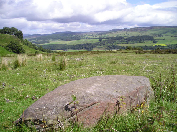
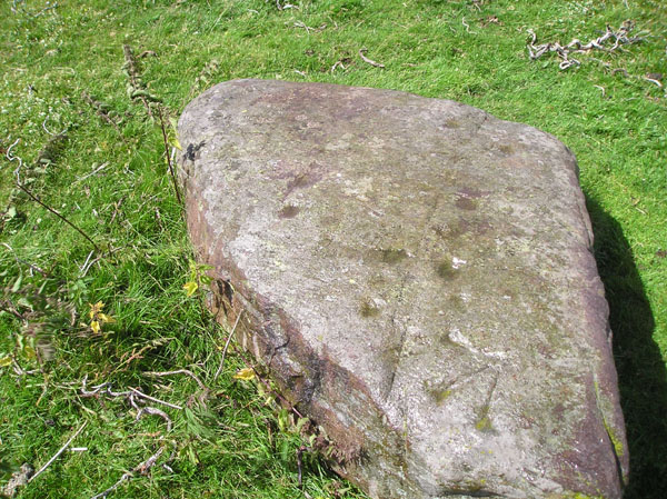
Creag Na Larach
Cup Marked Stone
Creag Na Larach (Cup Marked Stone) on The Modern Antiquarian, the UK & Ireland's most popular megalithic community website. 3 images, 1 fieldnote, plus information on many more ancient sites nearby and across the UK & Ireland.
Image © tiompan
Nearest Town:
Pitlochry (10km NNW)
OS Ref (GB):
NN978487 /
Sheets: 52, 53
Latitude:
56° 37' 8.3" N
Longitude:
3° 39' 56.29" W
Added by
tiompan
Images (3)
Fieldnotes (1)
0 discussions
Start a topic
Show |
Hide
Web searches for Creag Na Larach
Flickr
Google
Google Images
MAGIC
The Megalithic Portal
Bing
Stone Pages
Streetmap.co.uk
Wikipedia
Show map
(inline Google Map)
- Sites within 20 km -
-
Kindallachan (2.12km NE) (8 posts)
Clachan More (2.33km E) (8 posts)
St. Anne's Well (2.44km E) (1 post)
Clach Glas (2.5km NNE) (8 posts)
Haugh Cottages (2.59km NNE) (2 posts)
Kilmorich (3.54km NE) (14 posts)
Clach Na Croiche (4.66km WNW) (24 posts)
Tigh Na Ruaich (4.69km NNW) (33 posts)
Tulliemet (5.22km NNE) (2 posts)
Craigbea (5.24km N) (3 posts)
Dunkeld Park Stone (6.73km ESE) (7 posts)
Pitnacree (6.77km WNW) (22 posts)
Meikle Logie (7.11km SSE) (6 posts)
Haugh of Grandtully Farm (7.32km W) (15 posts)
Grantully Hill (7.91km W) (2 posts)
Ballinloan (8km S) (5 posts)
Dundonnachie (8.12km SE) (5 posts)
Clach Na Buidseach (8.2km WNW) (3 posts)
Tullypowrie (8.2km WNW) (8 posts)
Craig Tombane (8.23km SSW) (4 posts)
Clach a' Mhoid (8.51km S) (1 post)
Dunfallandy (8.84km NW) (6 posts)
Little Tombane (8.87km SSW) (3 posts)
Clachan An Diridh (8.9km WNW) (65 posts)
Knoc-Na-Eaglais (9.2km W) (2 posts)
Benachally (9.3km ENE) (8 posts)
Balendune (9.36km W) (7 posts)
Little Trochry (9.73km SSE) (16 posts)
Lundin Farm (9.75km W) (43 posts)
Pitcastle (9.9km W) (3 posts)
Creagan Fheadaire (9.9km W) (4 posts)
Middleton of Derculich (9.92km W) (6 posts)
Lundin (10.07km W) (5 posts)
Newtyle Two Poster (10.1km ESE) (13 posts)
Meikle Findowie (10.26km S) (23 posts)
Airlich Hill (10.39km S) (3 posts)
Carn Tulach (10.52km W) (8 posts)
Loch Benachally (10.57km ENE) (5 posts)
White Cairn (10.58km SW) (6 posts)
Lurgan Farm (10.6km W) (6 posts)
Clachan Aoradh (10.61km SSW) (14 posts)
Cnoc Dubh (10.61km NW) (2 posts)
Benachally (10.66km ENE) (9 posts)
Birnam Hill (10.74km ESE) (10 posts)
Tom-an-Droighne (10.79km W) (0 posts)
Ninewells (10.92km E) (6 posts)
Corrody Burn (10.96km SSW) (11 posts)
Balnakeilly Stone (11.15km NW) (19 posts)
Pitcarmick Burn (11.16km NE) (0 posts)
Faskally - Pitlochry (11.21km NW) (34 posts)
Pitcarmick Burn 4 (11.22km NE) (5 posts)
Dane's Stone (11.27km NW) (27 posts)
Balnakeilly (11.34km NNW) (10 posts)
Craig Obney (11.36km SE) (5 posts)
Sherriffmuir (11.43km ENE) (7 posts)
Pitcarmick Burn 3 (11.43km NE) (8 posts)
East Cult Standing Stones (11.45km E) (27 posts)
Pitcarmick Burn 2 (11.47km NE) (8 posts)
Kincairney (11.51km E) (4 posts)
Pitcarmick Burn (11.79km NE) (6 posts)
Craigiedun (11.79km NW) (8 posts)
Baledmond (12.13km NW) (7 posts)
Glen Derby (12.46km NNE) (4 posts)
Glassie (12.55km W) (8 posts)
Innercochill (12.62km SW) (3 posts)
Staredam (12.64km ESE) (18 posts)
Urlar Burn (12.71km WSW) (2 posts)
Badyo (12.75km N) (6 posts)
Sack Stone (12.86km SSE) (6 posts)
Witch's Stone (12.87km ESE) (11 posts)
Tullybeagles Moor (12.96km SE) (7 posts)
Murthly Castle (12.98km ESE) (7 posts)
Mains Of Fordie (13.03km E) (14 posts)
Muirheadstone (13.03km ESE) (11 posts)
Coilleaichur (13.08km WSW) (5 posts)
Ballinreigh (13.09km SW) (1 post)
Dalnabreck (13.12km ENE) (7 posts)
An Torr (13.24km WSW) (11 posts)
Boltachan Burn (13.37km W) (0 posts)
Ranageig 2 (13.45km ENE) (10 posts)
Ranageig 1 (13.49km ENE) (13 posts)
Cairn Muir (13.57km E) (6 posts)
Balnabroich Two Poster (13.75km ENE) (20 posts)
Balnabroich Stone (13.86km NE) (16 posts)
Balnabroich standing stone (13.89km ENE) (5 posts)
Gormack Muir (13.9km E) (12 posts)
Middleton Muir 6 (13.97km E) (5 posts)
Glendelvine Cairn (14.18km E) (6 posts)
Glendelvine House (14.22km E) (9 posts)
Balchrochan (14.36km NE) (6 posts)
Caputh (14.37km E) (9 posts)
Gormack Muir (14.58km E) (6 posts)
Middleton Muir 4 (14.68km ENE) (7 posts)
Balnabroich Cairn (14.74km ENE) (6 posts)
Muir Of Gormack (14.75km E) (5 posts)
Castle Menzies Cursus (14.76km W) (1 post)
The Grey Cairn (14.76km ENE) (12 posts)
Farmers Field (14.77km E) (6 posts)
Balnabroich (14.82km ENE) (16 posts)
Middleton Muir 3 (14.88km ENE) (10 posts)
Balnabroich Settlement (14.93km ENE) (9 posts)
Black Burn (14.99km WSW) (46 posts)
Shian Burn (15.03km WSW) (0 posts)
Middleton Muir 1 (15.05km ENE) (6 posts)
Middleton Muir 5 (15.08km ENE) (11 posts)
Middleton Muir 2 (15.09km ENE) (5 posts)
Balnabroich kerbed cairn 1 (15.15km ENE) (5 posts)
Shian Burn (15.17km WSW) (3 posts)
Dalnavaid (15.19km N) (4 posts)
Turrerich (15.28km WSW) (9 posts)
Wester Kinloch (15.31km SW) (10 posts)
Old Faskally (15.34km NW) (4 posts)
Balhomais (15.36km W) (17 posts)
Old Faskally (15.37km NW) (4 posts)
Corrymuckloch (15.45km SW) (19 posts)
Hill Of Cally (15.8km ENE) (9 posts)
Ardtulichan (15.83km WNW) (3 posts)
Ardtulichan (15.86km WNW) (3 posts)
Druids Park (Murthly Hospital) (16.02km ESE) (8 posts)
Killiecrankie (16.07km NW) (17 posts)
Loch Freuchie (16.08km SW) (6 posts)
Straloch Stone (16.12km NNE) (19 posts)
Queen's View (16.15km WNW) (5 posts)
Pitsundry (16.17km ESE) (6 posts)
Braco (16.21km SSE) (4 posts)
Giant's Grave, Enochdhu (16.43km NE) (8 posts)
Balvarran (16.44km NE) (5 posts)
Nether Tullicro (16.45km W) (0 posts)
Wester Enochdhu (16.45km NNE) (18 posts)
Ardtulichan (16.46km WNW) (6 posts)
Croft House Stone (16.56km NNE) (20 posts)
Carnashach Wood (16.64km E) (5 posts)
Craig Hill (16.65km WSW) (59 posts)
Kinloch (16.66km E) (8 posts)
Whitefield (16.7km NE) (6 posts)
Tullichuil (16.8km WSW) (4 posts)
Strathgarry (16.8km WNW) (6 posts)
Tulloch (16.9km NNE) (11 posts)
Lettoch (16.95km NW) (7 posts)
Witch's Stone, Straloch (16.95km NNE) (7 posts)
Mains Of Persie (16.98km ENE) (10 posts)
Dundavie (17.04km WNW) (3 posts)
Gleann Fearnach (17.04km NNE) (5 posts)
The Appin of Dull (17.34km W) (12 posts)
Garrow (17.35km WSW) (4 posts)
Fincastle Farm (17.48km WNW) (5 posts)
Carse Farm I (17.53km WSW) (26 posts)
Carse Farm II (17.54km WSW) (11 posts)
Remain Rock (17.77km WSW) (5 posts)
Sithean Na Cluana (18.06km NW) (0 posts)
Croft Moraig (18.09km WSW) (75 posts)
Calamanach (18.17km NE) (5 posts)
Creag Odhar (18.19km WNW) (4 posts)
Strathgroy (18.3km NW) (7 posts)
Loak (18.38km ESE) (7 posts)
Glen Clune (18.42km NW) (3 posts)
Loak (18.52km ESE) (7 posts)
Newhall Bridge Two Poster (18.54km WSW) (31 posts)
The Kor Stone (18.67km S) (5 posts)
Braes of Balloch (18.68km WSW) (8 posts)
Tombuie Cottage (18.76km WSW) (4 posts)
Leys of Marlee (18.78km E) (37 posts)
Comrie Bridge (18.85km WSW) (7 posts)
Glen Clune (18.91km NW) (5 posts)
Pitmackie (18.99km WSW) (6 posts)
Na Carraigean (19.18km WNW) (40 posts)
Cairn Gleamnach (19.2km ENE) (18 posts)
Balnabodach (19.26km W) (11 posts)
Tulach Hill (19.26km WNW) (7 posts)
Clach na h' Iobairt (19.44km WNW) (9 posts)
Glenkilrie 3 (19.6km NE) (5 posts)
Dun Mor (19.64km SSW) (7 posts)
Lurgan (19.68km W) (42 posts)
Glen Fender (19.7km NW) (5 posts)
Fir Hillock (19.7km E) (6 posts)
Braes of Taymouth (19.81km WSW) (4 posts)
Clach Ossian (19.87km SSW) (21 posts)
Faire Na Paitig (19.88km NNE) (20 posts)
Tomintianda (19.96km W) (4 posts)
Glenkilrie (19.96km NE) (7 posts)
- Facilities within 20 km -
-
Robert Menzies delicat... (Cafe: 7.7 km SE)
Taybank Hotel (Hotel: 7.8 km SE)
Pitlochry Backpackers ... (Youth Hostel: 10.3 km NW)
The Moulin Inn (Hotel: 11 km NNW)
Breadalbane Arms Hotel (Pub: 12.2 km W)
Black Watch Inn (Pub: 12.3 km W)
Faskally Caravan Park (Camping Site: 12.7 km NW)
House of Menzies (Cafe: 14.5 km W)
Tulloch Guest House (Bed & Breakfast: 16.6 km NNE)
Loch Tummel Inn (Pub: 19.7 km WNW)
Meikleour Hotel (Pub: 20 km ESE)
- Add -
-
Add news
Add an image
Add fieldnotes
Add folklore
Add miscellaneous
Add a link
-
Add a site
Add a nearby facility
Add an alternative name/spelling
Images
(click to view fullsize)
Add an image
Fieldnotes
Add fieldnotes
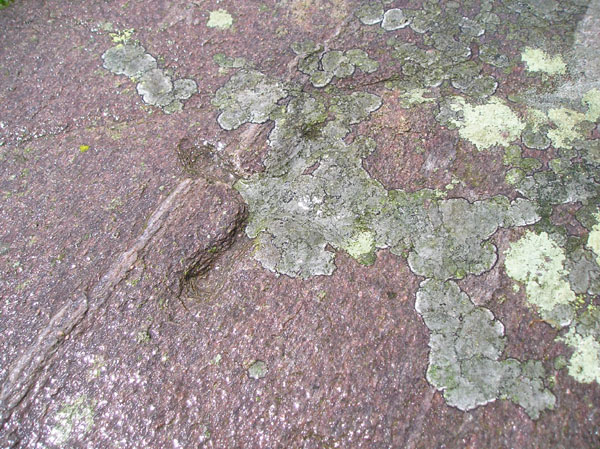
Found this site a couple of weeks ago. Did the O.S. chappie really fail to see the cups? The third period of markings include the cross incised stone with very small "cups " at the terminals. There are a few other marked rocks in the area.
Comments (0)
|
Add a comment
|
Permalink
Posted by
tiompan
20th July 2005ce
Edited 21st July 2005ce

 Posted by tiompan