The Modern Antiquarian
Log in
|
Register
Home
Latest Posts
Forums
Maps
Help
Browse Sites
News
Blog
Contributors
The Books
Select
-
Belgium
Denmark
Eire
France
Germany
Greece
Italy
The Netherlands
Norway
Portugal
Republic of Malta
Spain
Sweden
Switzerland
United Kingdom
County Waterford
Ballyquin
Ballyquin
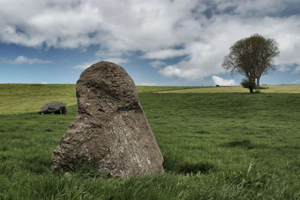
Standing Stone / Menhir
Ballyquin (Standing Stone / Menhir) on The Modern Antiquarian, the UK & Ireland's most popular megalithic community website. 2 images, plus information on many more ancient sites nearby and across the UK & Ireland.
Image © tmulraney
Nearest Town:
Mullinavat (17km NE)
OS Ref (IE):
S412179 /
Sheet: 75
Latitude:
52° 18' 40.77" N
Longitude:
7° 23' 45.02" W
Added by
FourWinds
Images (2)
0 discussions
Start a topic
Show |
Hide
Web searches for Ballyquin
Flickr
Google
Google Images
The Megalithic Portal
Bing
Stone Pages
Wikipedia
Show map
(inline Google Map)
- Sites within 20 km -
-
Ballyquin (0.1km N) (10 posts)
Ballyquin (1.2km NE) (4 posts)
Mothel Stone (2.19km SW) (5 posts)
Sheskin (4.24km W) (0 posts)
Whitestown (4.29km SE) (0 posts)
Glenaphuca (5.52km S) (0 posts)
Whitechurch (6.4km N) (5 posts)
Coolnahorna (7.03km SW) (0 posts)
Ballyhenebery (7.19km NNE) (5 posts)
Croughaun Hill (7.59km SSW) (0 posts)
Parkbeg (8.72km W) (0 posts)
Rathmaiden (9.06km SSW) (0 posts)
Graigavalla (9.17km WSW) (0 posts)
Owning (9.53km NNE) (4 posts)
Castletown (Iverk By.)/Kilkieran (9.64km N) (3 posts)
Ballyhussa (9.75km SSE) (0 posts)
Curraghkeily (10.38km W) (0 posts)
Bawnfree Hill (10.54km N) (16 posts)
Garryduff (10.87km NNE) (4 posts)
Kealfoun (10.94km SSW) (0 posts)
Lissahane (11.98km SE) (0 posts)
Knockroe (13.29km NNW) (47 posts)
Kilmogue Standing Stone (13.57km NE) (1 post)
Kilmogue (13.71km NE) (35 posts)
Ballinvir (13.89km NW) (2 posts)
Meallaghmore (13.98km N) (1 post)
Carrigeen (14.05km WSW) (2 posts)
Ballypatrick (14.05km WNW) (3 posts)
Knockroe (Kells By., Killamery ED) (14.19km NNW) (3 posts)
Kiltrassy (14.19km NNW) (3 posts)
The Sweep (14.49km ESE) (0 posts)
Powersknock (14.49km ESE) (1 post)
Templemichael (14.55km NW) (2 posts)
Knockanaffrin (14.62km WSW) (4 posts)
Raheens (14.75km ESE) (0 posts)
Cloghadda (14.97km W) (0 posts)
Bawnard (15.69km W) (0 posts)
Gurteen Lower (15.69km W) (0 posts)
Whitfield (15.95km ESE) (2 posts)
Savagetown (16.28km SE) (0 posts)
Castlecraddock (16.57km SE) (0 posts)
Savagetown (16.57km SE) (4 posts)
Ballynageeragh (16.94km SE) (19 posts)
Kilbarrymeaden (16.99km SE) (5 posts)
Slievenamon (17.1km WNW) (7 posts)
Drumlohan (17.2km SSW) (12 posts)
Gaulstown (17.23km ESE) (24 posts)
Gaulstown Cist (17.23km ESE) (1 post)
Crough (17.24km ESE) (0 posts)
Tooreen Circle (17.38km WSW) (4 posts)
Tooreen Barrow (E) (17.38km WSW) (0 posts)
Sheegouna (17.42km WNW) (6 posts)
Tooreen Row (17.53km WSW) (2 posts)
Poul-na-maddra-ruadh (17.66km SW) (3 posts)
Monavullagh South Cairn (17.67km SW) (0 posts)
Poul-na-maddra-ruadh (17.67km SW) (3 posts)
Monavullagh North Cairn (17.73km SW) (0 posts)
Monavullagh Central Cairn (17.74km SW) (0 posts)
Ballymote (17.79km ESE) (7 posts)
Ballymote Barrow (17.79km ESE) (1 post)
Tooreen Barrow (W) (17.82km WSW) (0 posts)
Jamestown (17.85km W) (3 posts)
Temple-etney (17.85km W) (1 post)
Monavullagh Standing Stone (18.2km SW) (4 posts)
Dunhill (18.21km SE) (12 posts)
Ballyvaheen Tomb (18.58km ENE) (0 posts)
Matthewstown (18.98km ESE) (9 posts)
Ballyvaheen (18.99km ENE) (2 posts)
Togher (19.13km WSW) (5 posts)
Coumeraglinmountain NE (19.34km SW) (0 posts)
Farnoge (19.36km ENE) (2 posts)
Ballynaclogh South (19.47km ESE) (2 posts)
Newmarket (19.69km NNE) (3 posts)
Coumeraglinmountain North Barrow (19.77km SW) (0 posts)
Knockeen (19.83km ESE) (12 posts)
- Add -
-
Add news
Add an image
Add fieldnotes
Add folklore
Add miscellaneous
Add a link
-
Add a site
Add a nearby facility
Add an alternative name/spelling
Images
(click to view fullsize)
Add an image
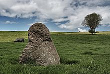 Image © tmulraney