The Modern Antiquarian
Log in
|
Register
Home
Latest Posts
Forums
Maps
Help
Browse Sites
News
Blog
Contributors
The Books
Select
-
Belgium
Denmark
Eire
France
Germany
Greece
Italy
The Netherlands
Norway
Portugal
Republic of Malta
Spain
Sweden
Switzerland
United Kingdom
Scotland
Argyll and Bute (Islands)
Jura
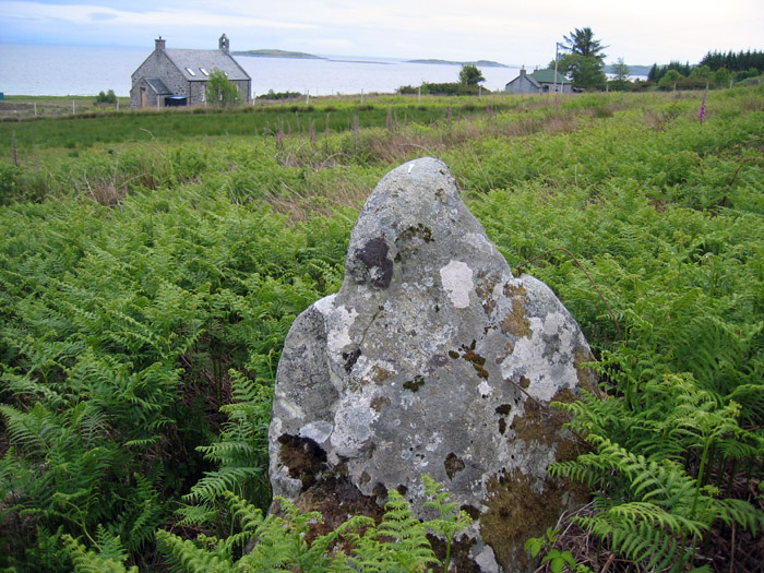
Leargybreck
Standing Stone / Menhir
Leargybreck (Standing Stone / Menhir) on The Modern Antiquarian, the UK & Ireland's most popular megalithic community website. 1 image, plus information on many more ancient sites nearby and across the UK & Ireland.
Image © Rockandy
Nearest Town:
Lochgilphead (35km NE)
OS Ref (GB):
NR538713 /
Sheet: 61
Latitude:
55° 52' 18.2" N
Longitude:
5° 56' 9.81" W
Added by
Paulus
Images (1)
0 discussions
Start a topic
Show |
Hide
Web searches for Leargybreck
Flickr
Google
Google Images
MAGIC
The Megalithic Portal
Bing
Stone Pages
Streetmap.co.uk
Wikipedia
Show map
(inline Google Map)
- Sites within 20 km -
-
Knockrome 2 (1.05km ENE) (6 posts)
Knockrome (1.2km ENE) (7 posts)
Knockrome 3 (1.24km ENE) (6 posts)
Knockrome 1 (1.38km ENE) (7 posts)
An Aird (2.12km ENE) (9 posts)
Cnocan Soilleir (2.18km ENE) (5 posts)
Ardfernal (2.23km ENE) (13 posts)
Druim Loisgte (2.45km E) (6 posts)
An Dunan (2.66km ENE) (17 posts)
Carn An Seirmonaich (2.91km SSW) (8 posts)
Abhainn A' Garbh-achaidh (3.48km NE) (5 posts)
Craighouse (3.82km SSW) (2 posts)
Keils (3.85km SSW) (8 posts)
Ardmenish (4.4km ENE) (23 posts)
Carn Liath (4.58km SSW) (15 posts)
Crackaig (5.5km S) (16 posts)
The Paps of Jura (5.5km WNW) (7 posts)
Carragh a' Ghlinne (5.53km SSW) (15 posts)
Sannaig (6.78km SSW) (9 posts)
Creag An Dunain (7.05km SSW) (12 posts)
Breac Dhunan (7.33km SW) (1 post)
Dun Doir A'Chrorain (7.52km NE) (13 posts)
Strone (8.19km SSW) (10 posts)
Ardfin Forest (8.42km SSW) (4 posts)
Abhainn na Sroine (8.72km SSW) (1 post)
Cladh Chlainn Iain (8.85km SSW) (3 posts)
Camas an Staca (9.88km SW) (18 posts)
Tarbert (12.81km NNE) (10 posts)
Carragh Chaluim Bhainn (12.97km NE) (10 posts)
Loch Ballygrant (14.06km WSW) (3 posts)
Finlaggan (14.8km WSW) (12 posts)
Cnoc Seannda (14.82km WSW) (11 posts)
Knocklearoch (15.24km WSW) (11 posts)
Suidh' An Eoin Mor (15.26km WSW) (4 posts)
Eilean Na Comhairle (15.33km WSW) (4 posts)
Eilean Mhuireill (15.57km WSW) (3 posts)
Glasgo Beag (15.58km WSW) (4 posts)
Dun Fhuarlit (16.43km ENE) (10 posts)
Ardnaw (16.75km ENE) (9 posts)
Dun A' Bhuilg (16.87km ENE) (14 posts)
Kilmory Knap Chapel (16.88km ENE) (4 posts)
Dun Na Doide (17.52km ENE) (10 posts)
Dun An Rudha Bhuide (18.62km SSW) (16 posts)
Dun A' Chaisteil (18.71km ENE) (10 posts)
Droineach (19.02km ENE) (11 posts)
Drum A' Chladha (19.16km ENE) (9 posts)
Dun Beag (Castle Sween) (19.62km ENE) (11 posts)
Old Ulva (19.69km ENE) (8 posts)
Castle Sween (19.76km ENE) (8 posts)
Trudernish (19.82km SSW) (8 posts)
Trudernish Point (19.88km SSW) (2 posts)
- Add -
-
Add news
Add an image
Add fieldnotes
Add folklore
Add miscellaneous
Add a link
-
Add a site
Add a nearby facility
Add an alternative name/spelling
Images
(click to view fullsize)
Add an image
 Image © Rockandy