|
|

|
|
BittonRound Barrow(s)
|
||||||||||||||||||||||||
|
|
|
Images (click to view fullsize) |
|
|
Fieldnotes |
|
|
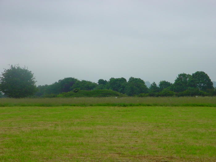
Visited 15.6.13 Directions: From Bristol take the A4175 south east to the pretty (posh) village of Bitton. Best place to park is near the church and walk along the ‘private road’, over a bridge and towards some stables which has a public right of way (signposted) Once you reach the stables the Barrow can be easily seen in a field to the right. The footpath leads across the fields to the Barrow on the appropriately named barrow Hill. The Barrow is approximately 2m high x 30m across and covered in overgrown long scruffy grass. It is fenced off – presumably to protect it from any horse damage? This was my only site of the day on a daytrip to Keynsham and a good one it was too. Well worth a visit if you are ever near the urban sprawl which is Bristol. p.s. If you seen horse manure for your garden this is the place for you. Unfortunately I left my shovel and bags at home – much to the relief of Karen and the children! |
Posted by CARL 18th June 2013ce |
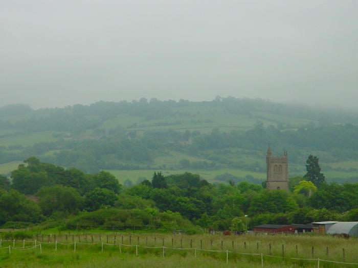
| Not much to add to Rhiannon's post, except that the stream is the small River Boyd, the barrow sits on an elevated rise above the river; note the presence of the church further to the east, and there is of course the old roman road (via Julia probably) that goes through Bitton. Could also be pre-existing prehistoric trackway which I am sure it was. Lynchets on the Golden valley side and of course the odd stone marked on 19th c maps following the line of the Boyd, not to forget that the occupant of the barrow must have decreed in his last will and testament, bury me down by the river with that hill (Kelston) in sight. |
 Posted by moss
18th June 2005ce |
| Tootling - nah, whizzing along the cycle path this morning I could see the barrow quite well. Admittedly it looked a bit more like a mound of dirt covered in weeds from this elevated angle. But I still like it. And not only does the fantastic Kelston Round Hill stand out like a beacon on the horizon, but now I could see that in the opposite direction was the distant but distinctive Maes Knoll. It's very flat here down here on the floodplain, so it seems an unusual place for a barrow. But there's no point in trying to compete with such monumental landscape features as the Round Hill by putting a barrow on the hillside. And besides, if the people lived down here on the fertile flat bit, then I suppose that's where their barrow ought to be. And perhaps the confluence of the stream and river has its relevance too. |
 Posted by Rhiannon
10th August 2004ce Edited 10th August 2004ce |
|
I stopped by here just as the sun was setting. I wasn't expecting to see much, but actually it was a pretty top spot. The sun-lit ridge of Lansdown and the barrow-shaped Kelston Round Hill made up the horizon on one side. Near the barrow on this side is a stream. This leads into the River Avon, which flows close by (unseen). An overall feeling for the landscape is a bit obscured by the old railway - though it's now a path and you'd probably get a good view from up here of the overall scene. What made me really mad at the time was how the field containing the barrow had been divided up by horse owners, who've stuck their usual 'private property keep out' signs all over the place. I felt rather intimidated, and was sure they'd blocked off the very footpath that goes right past the barrow. However, I wasn't feeling brave enough to get shirty with them. So I didn't approach the barrow as I would have liked (and as would seem perfectly reasonable from the map). My 1:50,000 map seems to have the paths in a different place to the larger scale one, and I would probably go back armed with the latter next time, and before I start whinging to the council about public footpaths*. I was annoyed at the time, but looking back I think this would be an interesting spot to return to. The barrow was quite big, unlike the usual vague bumps you get used to seeing, and its position in the landscape seems interesting. *you can now cross the fields quite easily - so long as you don't mind horses nibbling at you. You just have to unhook bits of fence and rehook them behind you. I'm sure it's better than it was. |
Posted by Rhiannon 20th January 2004ce Edited 26th April 2005ce |
Miscellaneous |
|
|
Pastscape Neolithic flint implements found during gravel working [Area centred ST 6742 6912] Neolithic Flint Implements - "A gravel pit is being worked at the present time at the lower end of Holm Mead Lane, S.W. of Bitton. Part of the pit lies below the flood level of the Avon ... Neolithic flint implements are found in the subsoil over the gravel." (1) The gravel pit, which is now disused and partially infilled, was centred at ST 67466918. (2) The finds were in the U.B.S.S. Museum, Bristol, but were destroyed by bombing in the 1939-45 war. (3) |
 Posted by Chance
14th October 2012ce Edited 8th April 2013ce |
|
Details of Barrows on Pastscape Probable round barrow sites, of Prehistoric or Roman date, seen as cropmarks A rapid examination of air photography (1a) suggests the presence of at least five probable round barrow sites, of Prehistoric or Roman date, visible as ring ditch cropmarks at:- ST 6763 6932, ST 6772 6923, ST 6779 6927 (possibly double-ditched), ST 6780 6932 and ST 6782 6935. (1) |
Posted by Chance 14th October 2012ce Edited 8th April 2013ce |
|
Details of Barrow on Pastscape [ST 67806945] TUMULUS [O.E.]. (1) ST 67806945, round barrow, 32 paces in diameter, 7 ft. high, visited 1st February, 1959. Flattish top. Under grass; no visible ditch. (2) The barrow consists of a low mound 1.0 m. high surmounted by a flat topped steep sided central tump, which is an additional 1.7 m. high. The periphery of the mound is very vague and there is no visible ditch. The barrow would seem to be between the bowl and bell types, although it may be simply a bowl barrow on a low natural mound with the berm produced by ploughing. The published survey (25-inch, 1931) has been revised. (3) Additional reference-field report (4) |
Posted by Chance 14th October 2012ce |
|
This is truly miscellaneous, stones that no longer exist. But just to the east of Bitton Barrow, in between two fields called Mickle Mead and Holm Mead there are several stones following a line just above the River Avon. So to record them for posterity the grid refs for Oldmap Uk are 367552,168907. Well they maybe stones from a stone circle given their site near the river (and the fact that Stanton Drew is not too far away), this part of the world has a lot of Roman history as well, situated under North Stoke, in the hills above with its large 'spout' of water by its church and of course the church in Bitton also supposedly a 'heathen' temple.. The present site of the stones (which must have been moved in the 19th C probably for the road) is I believe a sewage plant! Map of stones.. http://maps.nls.uk/geo/explore/#zoom=16&lat=51.4175&lon=-2.4674&layers=6&b=1 |
Posted by moss 5th February 2012ce Edited 20th November 2017ce |