|
|

|
|
Iron HoweAncient Village / Settlement / Misc. Earthwork
|
||||||||||||||||||||||||
|
|
|
Images (click to view fullsize) |
|
|
Fieldnotes |
|
|
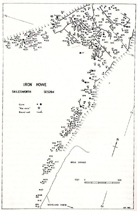
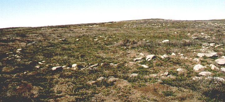
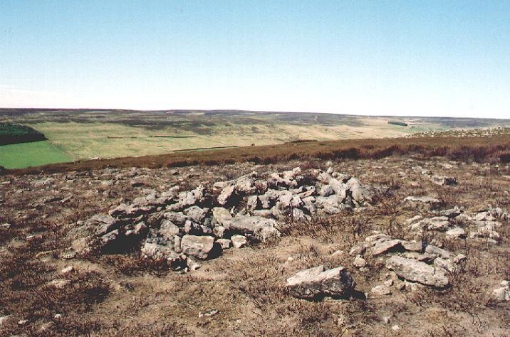
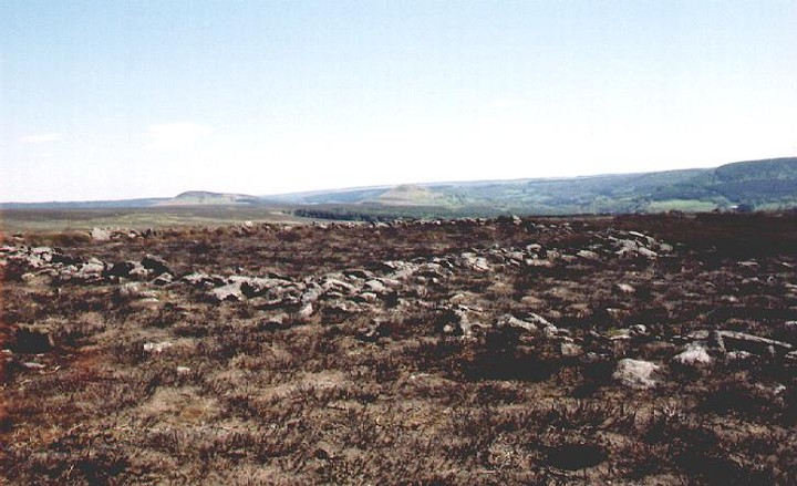
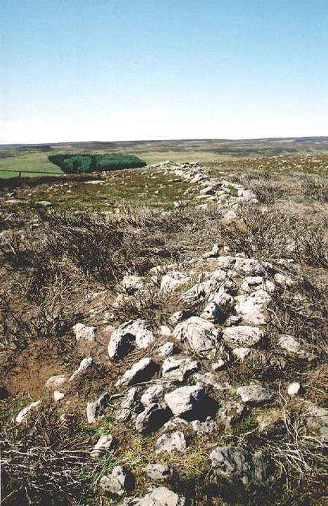
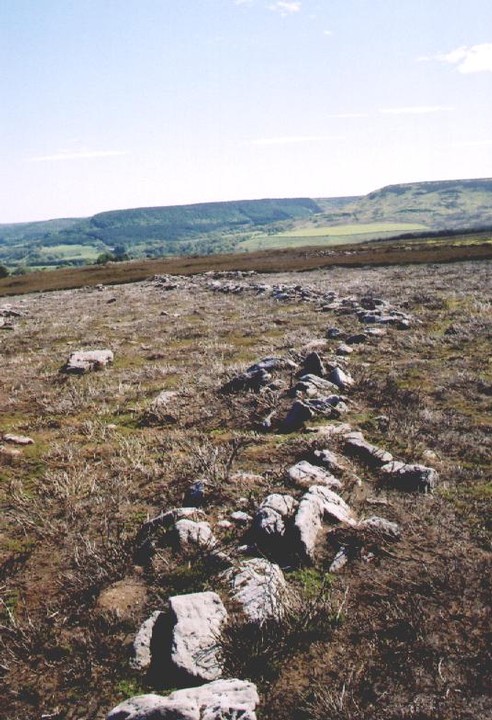
The easiest way to access this site is to park up at SE527939 and follow the footpath up onto the ridge, the Ridge runs between Parci Gill to the east and Arns Gill to the west. Once you pass the small conifer plantation to your left you will start to notice the small cairns and low walls poking through the heather. I was quite fortunate when I visited the site as the gamekeepers had burned-back a substantial amount of heather thus exposing large amounts of the site. There are no sheep on this part of the moor, so the only company I had was a solitary snipe who followed me around the moor singing out her shrill warning to no-one in particular that there was a stranger on the moor. As you move up the ridge, the freqency of cairns and low walls increases until you find yourself in an area that I can only describe as 'cairn chaos'. There are alignments everywhere -irregularly regular comes to mind. The local name for this place is 'Stone Folds' My 21st century head tells me that there should be fields with cairns on the margins but this just isn't the case here. There are wall enclosing cairns and walls leading from one cairn to another. Despite the huge efforts of creating the cairns, the ground around them remains very stoney. I can't make head nor tail of whats going on. There is one well defined recto-linear 'field' but every thing else is chaos. My mind is flooded with questions. Why so many cairns? over 300 of them. Why did they create so many small cairns as opposed to a number of large cairns? What was the purpose of the walling ? A huge effort has gone into creating these cairns yet there are only two hut circles visible on the ridge and these are only about 10m in diameter. Did the creators of the cairnfield live here? If the purpose of this site was for agriculture, I very much doubt that it would have been a place for growing crops, the ground is just too stoney, therefore it would have had to have been a place where animals were kept possibly a prehistoric stock yard. The ridge is known as 'Cow Ridge' But I'm still not convinced, the place is just TOO busy. There have been a number of Mesolithic flints found on the western side of the ridge so this place was visited by the earliest of the North York Moors peoples. Could it be that this place is more than a mundane agricultural site? Another reason to mooch up here is the views. To the south east you have the two great whalebacks of Hawnby Hill and Easterside Hill with the Tabular Hills beyond. To the south you have the imposing massif of Arden ( Arden - Wolves or Eagles Valley) Great Moor which terminates in the south west at Black Hambleton. To the east, west and north you have the vast expanse of the North York moors with it's ridges and valleys stretching to the horizon. All in all I would recommend that you check this place out. It will probably confuse the crap out of you, but there's nowt wrong with that. |
 Posted by fitzcoraldo
20th May 2004ce Edited 20th May 2004ce |
Miscellaneous |
|
|
Daftness nivver builds owght wo'th leaving up. Traditional |
Posted by fitzcoraldo 20th May 2004ce |
|
"The most interesting of these groups (cairns), which are well worth a visit, are those around Iron Howe, on the southern tip of Cow Rig, between Parci Gill and Arnsgill on Snilesworth Moor, 900 to 1,025ft. OD. Here are plots and enclosures and over 300 cairns, including a strange, elongated construction joining two cairns about 25ft apart. There is a total of 1 1/4 miles of walling, probably field boundaries". A History of Helmsley Rievaulx & District Members of the Helmsley & Area Group of the YAS Stonegate Press 1968 |
Posted by fitzcoraldo 19th January 2004ce Edited 19th January 2004ce |
|
"The walling here is the most highly developed on the moors and there appear to be the remains of drove ways between the walls. Nearby is a Mesolithic site. On one visit I spotted a very strange stone which, with the permission of Lord Ingelby, I excavated. It consisted of a block of coarse limestone about 16ins high and a base 14ins by 17ins; from near the top, at the back of the stone, running down to the base at the front, is a deep channel, in cross-section thistle-head shaped, 9ins across the top of the thistle and about 7ins in diameter in the body part. What this represents has yet to be determined". The North York Moors Stanhope White Dalesman Books 1979 |
Posted by fitzcoraldo 19th January 2004ce Edited 19th January 2004ce |