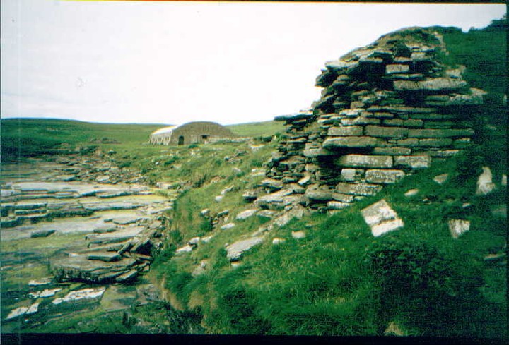
The Modern Antiquarian
Log in
|
Register
Home
Latest Posts
Forums
Maps
Help
Browse Sites
News
Blog
Contributors
The Books
Select
-
Belgium
Denmark
Eire
France
Germany
Greece
Italy
The Netherlands
Norway
Portugal
Republic of Malta
Spain
Sweden
Switzerland
United Kingdom
Scotland
Orkney
Rousay
South Howe
Broch
South Howe (Westside/Brough) (Broch) on The Modern Antiquarian, the UK & Ireland's most popular megalithic community website. 1 news item, 1 image, 1 fieldnote, 1 weblink, plus information on many more ancient sites nearby and across the UK & Ireland.
Image © greywether
Also known as:
Westside
Brough
Nearest Town:
Kirkwall (22km SSE)
OS Ref (GB):
HY373304 /
Sheet: 6
Latitude:
59° 9' 21.49" N
Longitude:
3° 5' 47.19" W
Added by
greywether
News (1)
Images (1)
Fieldnotes (1)
Miscellaneous (1)
Links (1)
0 discussions
Start a topic
Show |
Hide
Web searches for South Howe
Flickr
Google
Google Images
MAGIC
The Megalithic Portal
Bing
Stone Pages
Streetmap.co.uk
Wikipedia
Show map
(inline Google Map)
- Sites within 20 km -
-
Midhowe (0.22km WNW) (17 posts)
Broch of Midhowe (0.36km WNW) (16 posts)
North Howe (0.43km WNW) (1 post)
Knowe of Rowiegar (0.71km SSE) (6 posts)
Knowe Of Swandro (0.76km SE) (3 posts)
Whoom (0.85km NW) (1 post)
Quendal (1.24km NNW) (1 post)
Westness (1.79km ESE) (1 post)
Knowe of Lingro (3.12km NE) (0 posts)
Broch of Burgar (3.41km SW) (6 posts)
Knowe of Grugar (3.51km SW) (15 posts)
Knowe of Lairo (3.53km ESE) (19 posts)
Burgar (3.57km SW) (12 posts)
Knowe of Ramsay (3.61km E) (4 posts)
Broch of Gurness (3.7km SE) (47 posts)
Loch of Wasbister (3.71km NE) (7 posts)
Knowe of Stenso (3.76km SSW) (13 posts)
Peterkirk (3.93km WSW) (7 posts)
Knowe of Burrian (4.03km ESE) (6 posts)
Knowe of Yarso (4.05km E) (33 posts)
Long Stone (4.23km ESE) (11 posts)
Lower Arsdale (4.79km WSW) (2 posts)
Blackhammer (4.95km E) (27 posts)
Knowe of Hunclett (5.2km E) (7 posts)
Quoys (5.34km SSE) (1 post)
Tammaskirk (5.34km E) (16 posts)
Redland North (5.42km SSE) (1 post)
Redland South (5.59km SSE) (16 posts)
Knitchen Hill (5.85km E) (4 posts)
Taversoe Tuick (5.97km E) (51 posts)
Ness of Woodwick (6.17km ESE) (12 posts)
Costa Hill (6.61km WSW) (5 posts)
Cubbie Roo's Burden (7.03km E) (6 posts)
Knowe of Midgarth (7.22km SE) (12 posts)
Yetnessteen (7.73km ENE) (7 posts)
Mittens (7.98km WSW) (4 posts)
Tingwall (8.08km SE) (28 posts)
Scockness (8.12km ENE) (10 posts)
Hundland Hill (8.14km WSW) (1 post)
Knowes of Lingro (8.98km WSW) (12 posts)
Knowes of Lingro (8.98km WSW) (3 posts)
Kirbister Hill (9.71km WSW) (1 post)
Crustan (9.85km WSW) (5 posts)
Seven Knowes (9.86km SE) (10 posts)
Knowe of Crustan (9.86km WSW) (13 posts)
Harraymen's Graves (10km S) (1 post)
Knowe of Nesthouse (10.47km WSW) (2 posts)
Newan (10.51km WSW) (7 posts)
Loch of Boardhouse (10.58km WSW) (9 posts)
Stanerandy (10.92km WSW) (18 posts)
Sandyhall (11.28km SE) (6 posts)
Knowe of Dishero (11.64km ESE) (15 posts)
Queena Fjold (11.77km WSW) (19 posts)
St. Magnus's Well (11.91km WSW) (6 posts)
St Mary's Kirk (Isbister) (11.96km SE) (8 posts)
Burrian (Corrigall) (12.01km SSW) (8 posts)
Knowe of Makerhouse (12.17km SW) (2 posts)
North Biggin (12.23km SW) (12 posts)
Ravie Hill (12.3km WSW) (4 posts)
Oyce of Isbister (12.47km SSE) (4 posts)
Dounby House (12.49km SW) (1 post)
Berrydale (12.49km WSW) (1 post)
Oxtro Broch (12.51km WSW) (15 posts)
East House (12.63km SW) (1 post)
Wheebin (12.64km WSW) (15 posts)
Lyde Road (12.89km SSW) (1 post)
Knowe of Buckquoy (12.94km WSW) (12 posts)
Point of Buckquoy (13.02km WSW) (11 posts)
Point of Buckquoy (13.02km WSW) (5 posts)
Quinni Moan (13.11km SW) (1 post)
Spurdagrove (13.19km WSW) (6 posts)
Knowes of Trotty (13.26km SSW) (14 posts)
Knowe of Skea (13.28km NE) (2 posts)
Knowe of Skea (13.29km NE) (2 posts)
Hourston (13.67km SW) (5 posts)
Knowes of Howana (13.8km SW) (1 post)
Nettletar (13.88km SSW) (8 posts)
Knowe of Skorn (14km WSW) (1 post)
Grind (14.22km SW) (1 post)
Burrian (Russland) (14.24km SW) (5 posts)
Chapel Knowe (14.88km SSE) (3 posts)
Appiehouse (14.92km SSW) (12 posts)
Knowes of Yonbell (14.99km WSW) (1 post)
Knowe of Burrian (Garth Farm) (15.02km SSW) (4 posts)
Maesquoy (15.18km SSW) (2 posts)
Fitty Hill (15.29km NNE) (1 post)
Vestrafiold (15.49km WSW) (1 post)
Knowe of Gullow (15.53km SSW) (4 posts)
Dale (15.54km SSW) (7 posts)
Staney Hill (15.54km SSW) (22 posts)
Staney Hill (15.64km SSW) (20 posts)
Henge (15.75km SSW) (3 posts)
Vetquoy (15.75km SW) (1 post)
Snaba Hill (15.81km S) (6 posts)
Feolquoy (15.88km SSW) (4 posts)
Wasdale (15.95km S) (42 posts)
Russel Howe (16.08km SW) (13 posts)
The Hillock (16.21km S) (18 posts)
Howe Harper (16.29km S) (16 posts)
Pickaquoy (16.36km SSW) (6 posts)
Rowamo Cottage (16.46km S) (4 posts)
Stockan (16.59km SW) (1 post)
Shennar Howe (16.68km SW) (2 posts)
Twi Ness (16.98km ESE) (5 posts)
Rosemount and Easthouse (17.08km SW) (1 post)
Upper Garson (17.09km WSW) (2 posts)
Hill of Heddle (17.09km S) (2 posts)
Burrian Broch (17.15km SW) (2 posts)
Grimston (17.21km SSW) (10 posts)
Setter Noost (17.3km ESE) (13 posts)
Linnahowe (17.33km WSW) (12 posts)
Hurkisgarth (17.35km SW) (3 posts)
Vola (17.36km SSW) (18 posts)
Skaill Church (17.43km WSW) (3 posts)
Millhouse (17.47km SW) (1 post)
Loch of Skaill Niche (17.49km SW) (4 posts)
Harray Viewpoint (17.56km SSW) (8 posts)
Ingshowe Broch (17.65km SSE) (21 posts)
Knowe of Verron (17.66km WSW) (24 posts)
The Fairy Knowe (17.69km S) (71 posts)
Skaill road (17.77km SW) (3 posts)
Crossiecrown (17.86km SE) (3 posts)
Lower Hobbister (17.96km SSW) (8 posts)
Quanterness (18.01km SE) (9 posts)
Rennibister (18.02km SSE) (42 posts)
Ring of Bookan (18.18km SW) (24 posts)
Quoybirse (18.2km NNE) (5 posts)
Stones of Via (18.25km SW) (6 posts)
The Brecks (18.26km SW) (56 posts)
Via Barrow (18.3km SW) (3 posts)
Unyatuak (18.32km E) (9 posts)
Via Mound (18.33km SW) (6 posts)
Via Mound (18.33km SW) (8 posts)
Stackrue-Lyking Mound (18.34km SW) (6 posts)
Skae Frue (18.36km SW) (15 posts)
Loch of Clumly (18.38km SW) (6 posts)
Bookan (18.4km SSW) (20 posts)
Stackrue Broch (18.4km SW) (22 posts)
Wasbister Cairn (18.45km SSW) (10 posts)
Bookan Cairns (18.47km SSW) (25 posts)
Burn of Mussetter (18.47km ENE) (0 posts)
Maeshowe (18.48km SSW) (88 posts)
Skara Brae (18.5km SW) (91 posts)
Saverock (18.5km SE) (15 posts)
Plumcake Mound (18.57km SSW) (9 posts)
Linga Fold (18.57km SW) (1 post)
Wideford Hill (18.61km SE) (52 posts)
Saverock (18.62km SE) (11 posts)
Fresh Knowe (18.62km SSW) (13 posts)
Nabban (18.65km SSE) (7 posts)
Wasbister Disc Barrow (18.65km SSW) (17 posts)
Wideford Hill (18.67km SSE) (10 posts)
Comet Stone (18.69km SSW) (36 posts)
Ring of Brodgar (18.69km SSW) (186 posts)
Eday Manse (18.74km ENE) (6 posts)
Ness of Brodgar Cairns (18.8km SSW) (1 post)
Ness of Brodgar (18.81km SSW) (49 posts)
Barnhouse Settlement (18.81km SSW) (64 posts)
Southside Stone (18.82km E) (3 posts)
Salt Knowe (18.83km SSW) (14 posts)
Stone of Odin (18.85km SSW) (14 posts)
Wideford (18.88km SE) (8 posts)
Lochview (18.9km SSW) (31 posts)
Broch of Steiro (18.94km ESE) (22 posts)
The Watchstone (18.98km SSW) (27 posts)
Voy (18.99km SW) (29 posts)
The Standing Stones of Stenness (19.02km SSW) (125 posts)
Knowe of Angerow (19.04km SW) (13 posts)
Eday Church (19.05km ENE) (2 posts)
Knowe of Nebigarth (19.05km SW) (3 posts)
Hillock of Burroughston (19.06km E) (14 posts)
Knowe of Geoso (19.09km SW) (12 posts)
Barnhouse Stone (19.12km SSW) (12 posts)
Burn of Cruland (19.24km SW) (3 posts)
Voy (19.57km SW) (5 posts)
Links of Noltland (19.59km NNE) (14 posts)
Knowe of Queen O'Howe (19.74km NNE) (0 posts)
The Pierowall Westray Stone (19.79km NNE) (5 posts)
Nether Bigging (19.81km SSW) (2 posts)
Broch of Borwick (19.82km SW) (25 posts)
Long Cairn (19.86km ESE) (62 posts)
Standing Stones Hotel (19.92km SSW) (6 posts)
Howe Hill (19.93km ESE) (6 posts)
Grain Souterrain (19.98km SE) (31 posts)
- Facilities within 20 km -
-
Atlantis Lodges (Holiday Cottage: 17 km S)
Balfour Castle (Hotel: 18.6 km ESE)
Shapinsay Heritage Centre (Museum: 18.6 km ESE)
Tormiston Mill (Cafe: 18.9 km S)
Lochend (Holiday Cottage: 19.8 km S)
- Add -
-
Add news
Add an image
Add fieldnotes
Add folklore
Add miscellaneous
Add a link
-
Add a site
Add a nearby facility
Add an alternative name/spelling
News
Add news
Roman coin find in Orkney thrills archaeologists
Archaeologists are thrilled by the discovery of a Roman coin during the excavation of an archaeological site in Orkney.
http://www.bbc.co.uk/news/uk-scotland-north-east-orkney-shetland-40606908
Comments (4)
|
Add a comment
|
Permalink
Posted by
drewbhoy
18th July 2017ce
Images
(click to view fullsize)
Add an image
Fieldnotes
Add fieldnotes
This site is on the Westness Heritage walk which starts at Midhowe.
Comments (0)
|
Add a comment
|
Permalink
Posted by
greywether
2nd December 2003ce
Miscellaneous
Add miscellaneous
RCAHMS NMRS record HY33SE 10 is the much eroded remains of an extensive settlement .
Comments (0)
|
Add a comment
|
Permalink
Posted by
wideford
2nd March 2004ce
Links
Add a link
Canmore
Archaeology Notes
Comments (0)
|
Add a comment
|
Permalink
Posted by
drewbhoy
18th July 2017ce