|
|

|
|
The Giant's StoneLong Barrow
|
|
|
|
Images (click to view fullsize) |
|
|
Fieldnotes |
|
|
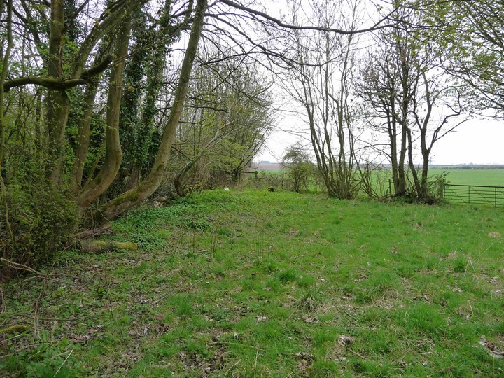
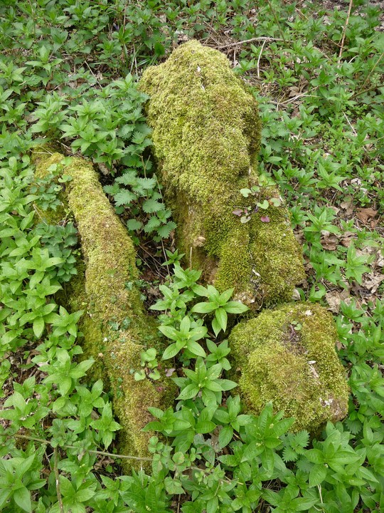
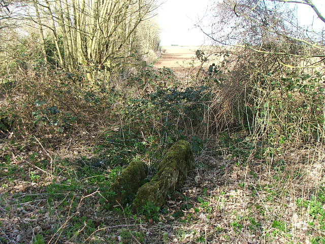
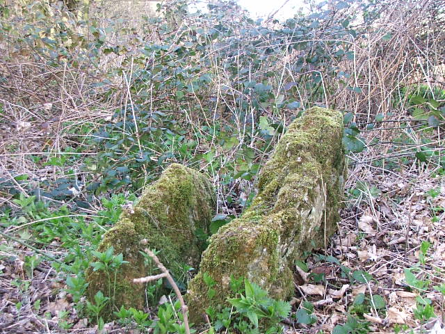
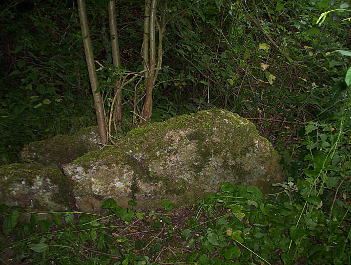
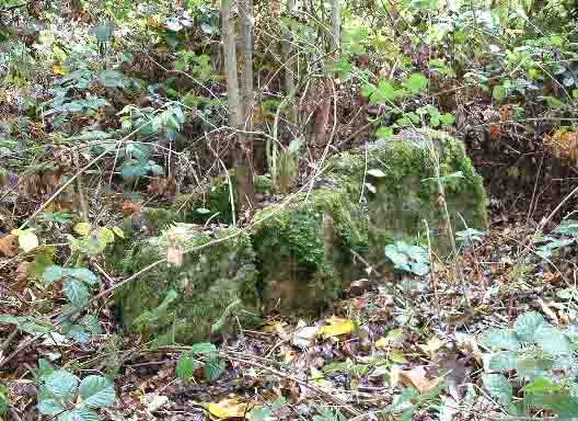
Visited 6.10.13 Directions: From the village of Bisley take the minor road east towards Battlescombe. The Giant’s Stone is on the left hand side of the road, amid some undergrowth / trees. Thanks to TSC for the directions. Without his help I doubt I would have found the stones. The trick is to drive along the road as far as some buildings (on the right) and then look out for a rusty metal field gate on your left. The lane is narrow but you can squeeze in next to the gate. Once over the gate go to your left and have a rummage about in the bushes next to the road. The stones are then pretty easy to spot. If you knew where to look you can see the stones from the road but finding them via the metal gate will make life a lot easier. In all honesty there is very little to see here other than 3 stones sticking out proud of the ground – forming a parallel row. In saying that, for some reason, I found this a nice little quite spot to spend a short while. It is not very likely you will be disturbed here. Not much to see but if you are in the area there are worse ways to spend a few minutes. p.s. The tree growing between the stones in some of the photos is no longer there - thankfully! |
Posted by CARL 8th October 2013ce |
|
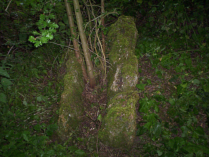
Visited on a grey Easter Sunday (12.4.09) after walking from Stroud via Bisley. Using Baza's directions, the stones are quite easy to find and at this time of year the vegetation is only just starting to grow up - the stones can currently be seen from the lane. There is little to be seen apart from the two upright slabs, covered in moss and positioned about 6 inches apart, on an east-west axis. From the east it is just about possible (by squinting/wishful thinking) to see what may be the remains of a low mound around the stones, but don't hold me to that. As the stones are placed so close together it is difficult to know what part of what kind of structure they formed. A brief note on access. The stones are right next to the lane, in a gated (unlocked) field. The lane itself is metalled up to a hundred yards or so to the west of the site, after which it becomes a rough, stoney track. Rather oddly, as the track doesn't seem to go anywhere, I saw two cars driving along it while I was there, one in each direction! It appears possible to park at the end of the metalled section and still leave room for other vehicles to pass. It's then a short stroll along the lane to the field gate. The monument is placed high up on the Cotswolds, with the hilltop being to the west - the spire of Bisley church is visible due west (which apparently was used as a landmark by bombers in WW2, due to its high situation). To the east the ground slopes away down to Holy Brook. Worth a quick poke about in the undergrowth if you're in the area. |
 Posted by thesweetcheat
15th April 2009ce |
| I have been looking for this for a few years. In the end I had to ask Baza and I finally found it. A little underwhelming but profoundly sad. I cleared the growth around the stone otherwise it is invisible. |
 Posted by hamish
23rd June 2004ce Edited 23rd June 2004ce |
|
Very little remains of this long barrow, which was nearly completely destroyed in the 19th century AD. All that's visibly left to see are two parallel slabs, set into the ground 6ins apart, and rising maybe 2ft above the ground, presumably part of a burial chamber. They're not easy to find, despite standing barely ten feet from Hayhedge Lane, a minor road running from the village of Bisley, one mile away. I entered into a field on the northern side of the road through a metal gate and walked westward to the corner of the field where they stand in the undergrowth. GPS: SO 91783 06122 |
 Posted by baza
6th November 2003ce Edited 6th November 2003ce |
Folklore |
|
|
"Men have had the terrifying experience of seeing headless human beings [here] which have vanished." (Thank god they vanished, eh. Mentioned in Trans Brist Glouc Arch Soc 1931.) Also, a look at the map shows that the stones are in 'Battlescombe' - you can't help speculating that they might be caught up in a story about people (or giants?) killed in battle - many megaliths are said to be such graves. Maybe if you live locally you know more?? |
 Posted by Rhiannon
4th April 2005ce Edited 4th April 2005ce |
Miscellaneous |
|
|
Details of Barrow on Pastscape The site of a Neolithic chambered long barrow, north of Battlescombe Farm. Known locally as The Giants Stone which referred to one of two vertical stones which originally formed the chambers and which were left standing after the barrow had been destroyed. Nothing of the barrow or either stone now remains. SO 91770611 The Giant's Stone (NAT) Burial Chamber (NR) (Remains of) (NAT) (1) A chambered long barrow, known as the Giant's Stone Barrow, was almost destroyed by 1883, although some of the stones forming the chambers remained. One of them was known locally as the Giant's Stone. Apart from two megaliths, 4 ft long and 2 ft above ground, there are now no traces of the barrow except for a slight indication of a mound. (2-5) This area is now completely covered by a tangle of fallen trees, overgrown with nettles and scrub. No trace of any mound could be found, and only one ivy-covered upright stone, 0.4 m high by 1.2 m wide by 0.1 m thick was located, at SO 91770611, as depicted on OS 25" (1). The name, 'The Giant's Stone', could not be verified locally. Published 1:2500 detail correct. (6) The stone know as 'The Giants Stone' was apparently originally part of a chambered long barrow. The barrow was virtually destroyed in 1883 although some of the stones froming the chambers remained. The site was visited by Crawford in 1920, and he noted that the barrow had been removed, or nearly so, leaving some of the stones which formed the chambers, especially a large one locally known as 'The Giant's Stone'. He recorded two vetical moss-grown stones spaced about 6 inches apart, placed parallel to each other, the tops of which were about 2ft above the ground, and alignd east-west. A visit in 1986 by R Cudby resulted in a report that according to local knowledge the stones were carted awy, and one of them was left beside the access to a field further up the lane to prevent cart from damaging the dry stoen wall. He located the site of the long barrow, but there were no obvious remains, although he thought that he saw broken fragments of one of the stones buried in the ground. The location given by the grid reference was visited. The stone was though to lie on the north side of a track. This track is bounded on the north and south sides by a dry stone wall, but the wall is demolished at the point where the stone should be, and there is no sign of the stone. There is also no obvious sign of a long barrow in the immediate vicinity. (7) The site of the Neolithic chambered long barrow referred to by the above authorities (1-7) was viewed on aerial photographs as part of The Cotswold Hilsl NMP survey but no earthworks or cropmarks were visible. (8) -------------------------------------------------------------------------------- SOURCE TEXT -------------------------------------------------------------------------------- ( 1) Ordnance Survey Map (Scale / Date) OS 25" 1913 ( 2) by G B Witts 1883 Archaeological handbook of the county of Gloucester, being an explanatory description of the archaeological map of Gloucestershire Witts, G.B. (1883) 79, No15 ( 3) by Glyn E Daniel 1950 The prehistoric chamber tombs of England and Wales Daniels, G.E. (1950) 225, No 32 ( 4) by O G S Crawford 1925 The long barrows of the Cotswolds Crawford O.G.S (1925) 100-101, No 28 ( 5) Transactions of the Bristol and Gloucestershire Archaeological Society O'Neill & Grinsell (1960) Gloucestershire Barrows, Lists: Long Barrows, Gloucestershire. 79 Page(s)72 ( 6) Field Investigators Comments F1 GB 11-OCT-77 ( 7) English Heritage Alternative Action Report J Heath, 09 March 1999 ( 8) RCHME/EH Aerial Photographers Comment Amanda Dickson/18-JAN-2010/English Heritage: Gloucestershire County Council: The Cotswolds Hills NMP |
 Posted by Chance
10th July 2012ce |