|
|

|
|
Gospel HillocksLong Barrow
|
||||||||||||||||||||||||
|
|
|
Images (click to view fullsize) |
|
|
Fieldnotes |
|
|
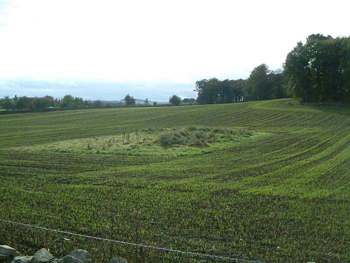
Another long barrow along the lines of The Tong. From what I can find out it's not for certain that this knobbly bit of land, 32x17m is really a long barrow.... Ok so it's orientated E-W.. but that don't necessarily make it so. In the field to the right the 'long barrow' is a smart little round barrow...well...it makes it that the journey wasn't a complete waste of time. |
9th October 2003ce Edited 9th October 2003ce |
Folklore |
|
The next day we repaired to the place, and shortly after we were met by Miss Pickford [..] who most obligingly gave us the history of the mound in question. She narrated as follows:-You can see a diagram of the three disturbed occupants of the barrow here in the article 'Archaeological notes made by Captain Francis Dubois Lukis, H. M. 's 64th Regiment, during a visit to Buxton, Derbyshire, in 1865' in 'Reliquary and Illustrated Archaeologist.' |
 Posted by Rhiannon
20th March 2009ce Edited 20th March 2009ce |
Miscellaneous |
|
|
Details of Barrow on Pastscape One of two barrows known as Gospel Hillocks (the other is recorded as SK 07 SE 4). The larger of the two, it was dug into in 1865 by Lukis. Two inhumations were found placed on a large stone slab. A polished flint axe was beside the head of one. Near both skeletons were several V-perforated jet buttons. A third skeleton lay close to the edge of the stone. Towards the north side of the mound was a dry-walled cist with paved floor containing two further inhumations plus a Beaker. Further Beaker sherds were present in the mound. The polished axe has been suggested as evidence that one of the inhumations may be of Neolithic date, although the nature of the original account and the manner of excavation leave some room for doubt about the association, while the presence of the axe need be no barrier to an Early Bronze Age date, particularly given the proximity of the jet beads and other inhumations. Little of the mound survives above ground. Recently, Barnatt recorded the barrow as a mutilated mound measuring circa 32 metres by 18.5 metres, orientated east-west, and argued that this present shape and its low-lying siting suggest that the monument may have been a long barrow. He also argued that because Lukis appears to describe a smaller mound than the one currently extant, there is no firm evidence that this waas indeed the mound that he dug into. Accordingly, he raises the possibility that another, lost, round barrow existed in the immediate vicinity and suggests that this postulated barrow was the one explored by Lukis. However, other sources seem quite clear that the mound at SK 08637148 was indeed the one dug by Lukis. For example, Ward, writing in 1899 and referring to Salt's excavation of adjacent barrow SK 07 SE 4, states that "it turned out...upon inquiry that Captain Luckis's [sic] barrow was the larger one to the south-west". Ward had originally thought that the Salts were in fact excavating the same barrow that Lukis had dug into because, like him, they found a large stone slab resting on the former ground surface, and the enquiries were necessary to confirm that Salt's barrow was not Lukis' barrow. Whereas Lukis had left the aforementioned stone slab in place, Salt had the one in his barrow raised, and found it to conceal a grave pit with inhumation (see SK 07 SE 4). (1-6) NB this barrow was originally recorded as part of SK 07 SE 4. That record should be consulted for additional sources and information. The round barrow is also visible as an earthwork on air photographs mapped as part of the Derbyshire and Peak District Aggregates Assessment Project. It is still extant on Google.Earth.com 06-SEP-2005 imagery (accessed on 22nd September 2009). (7) -------------------------------------------------------------------------------- SOURCE TEXT -------------------------------------------------------------------------------- (1) The Reliquary Lukis, FC. Archaeological notes made by Captain Francis Dubois Lukis, HM's 64th regiment, during a visit to Buxton, Derbyshire in 1865. 8, 1868 Page(s)81-7 (2) Proceedings of the Society of Antiquaries of London Ward, J. Gospel Hillock. 17, 1897-9 Page(s)310-12 (3) D L Clarke 1970 Beaker pottery of Great Britain and Ireland Gulbenkian archaeological series Page(s)478, 545, 552 (4) by Barry M Marsden 1977 The burial mounds of Derbyshire Page(s)65 (5) by Ian Kinnes 1979 Round barrows and ring-ditches in the British Neolithic British Museum occasional papers no.7 Page(s)22 (6) John Barnatt and John Collis 1996 Barrows in the Peak District : recent research Page(s)86, 135 (7) Vertical aerial photograph reference number Next Perspectives PGA Imagery Tile Ref:SK0871 Date:2005-09-06 |
 Posted by Chance
10th July 2012ce |