|
|

|
|
Ferrybridge HengeHenge
|
||||||||||||||||||||||||
|
|
|
Images (click to view fullsize) |
|
|
Fieldnotes |
|
|
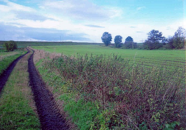
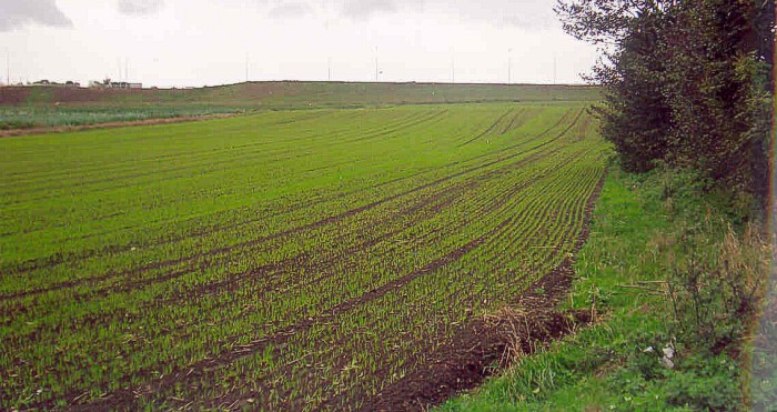
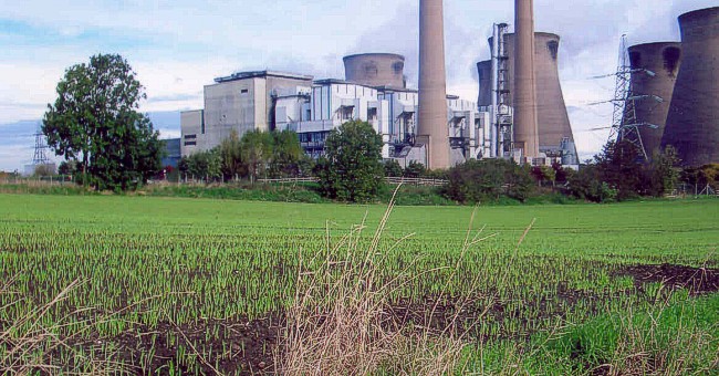
As this is the closest site to home, I went to have a look - but there really isn't a lot there to see ... To get there: Take the road from Castleford to Ferrybridge and turn right into an estate called Pollard's Fields, immediately opposite the main gate for Ferrybridge C power station. Park up and then walk back up the main road towards Castleford, with the power station on your right. There is a farmer's lane to your left running parallel to the road. Join this, and it takes you into the field where the henge is (see photo above). This is a very difficult site to decipher when there are crops, and the only above ground evidence I could see was a raised area in the field of crops, which according to the plan provided by the "local site" link below is part of the banking of the henge (see photo). I also took a photo from the centre of the henge area towards the power station. Apparently the far left of the photo is where the outer banking meets the road. Walking the perimter of the field / road only confuses matters - particularly with all the road building works which are ongoing at present and which doubtless in the future will have altered the geography somewhat. Most of this once sacred landscape has been flattened, and I did feel a bit like I was standing in an island between several motorways, what with the the powerstation on one side, the M62 on the other - and now the new A1(M) improvement route is in the process of eating up a large part of the remaining area. |
27th October 2005ce |
Miscellaneous |
|
|
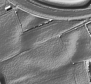
Details of henge on Pastscape [SE 474242] Circular soil mark, average diameter 180m with a possible entrance to the SW. Possible a henge, comparable in size and situation with the Thornborough circles 36 miles to the NW [SE 27 NE 4]. (1) Surveyed at 1/2500. This feature lies mainly in two ploughed fields and is visible as a circular bank of very slight profile, now considerably spread by cultivation and partly destroyed by the cutting of a new road. Two slight depressions in the bank to NE and SW probably indicate original opposed entrances, both of which are now bisected by a modern track. APs show markings of an outer ditch in the NW quadrant which is visible on the ground as a superficial depression, but is not surveyable. The interior of the enclosure has a slightly domed appearance, which is probably caused by the ploughing out of an internal ditch. The earthwork has all the characteristics of Atkinson's Class IIa 'Henge', thus favouring its comparison with the Thornborough Circles. (2) In May 1992 the RCHME: Ferrybridge Henge Project recorded the cropmark of a circular henge ditch, 10m in width, at SE 4746 2424. The ditch has opposed entrances to the ENE and WSW; both east and west terminals of the southern arc are clearly defined, but those of the northern arc are slighted by a farm track. The maximum width of the causeway entrances is estimated as 20m for the ENE and 30m for the WSW. Concentric with the ditch and outside it, a bank approximately 15m wide, also has opposed entrances. Both entrance terminals are recorded on the WSW, and on the ENE that of the southern arc only (the NE quadrant of the bank is now destroyed). Between the inner ditch and the henge bank is a berm approximately 25m wide. Outside the bank is an ill-defined ditch, maximum width 26m, which is recorded on all sides except in the destroyed NE quadrant; this would confirm the previous classification by Authority 2 of a Class IIa Henge. A previous air photo transcription omits the outer ditch (3a). The internal diameter of the henge measures 100-102m; the external diameter of the henge measures 240-260m. The cropmark of a ring ditch (SE 42 SE 61) occupies the full width of the berm at SE 4748 2418, in the SSE sector of the henge. The relationship between the ring ditch and the henge is not clear. A full report and a plan can be found in the NMR archive (Coll UID 922907). West Yorkshire Archaeology Service is undertaking a phased programme of survey and excavation to study and record the threatened landscape setting of the henge monument (3b). Excavation in 1991 of a section across the henge earthwork also confirmed the presence of an outer ditch and revealed details of the bank's construction. (3) SE 474 246. Earthwork W of Ferrybridge. Scheduled No WY/720. (4) Cropmark/soilmark remains of the henge at Ferrybridge were recorded as partof a 1:2500 scale aerial photographic survey carried out by the RCHME between 6th and 9th June 1997 as part of the RCHME: Industry and Enclosure in the Neolithic project. The plan of the henge and surrounding features, digital files and report are held by the RCHME (Collection UID: 1082880). (5) The henge at Ferrybridge is visible as cropmarks and slight earthworks on air photographs. It has been recorded as part of a 1:10000 scale aerial photographic survey carried out by the Lower Wharfedale NMP project. The henge is as described by previous authorities. The ring ditch of the barrow that is located within the henge (described by authority 3 and also in SE 42 SE 61) has also been plotted as part of this survey. For the sake of clarity all the features associated with the henge shall be described in records SE 42 SE 132 and SE 42 SE 133. (8-9) |
 Posted by Chance
28th December 2014ce |
| The Highways Agency and Archaelogical Services WYAS have produced a booklet on the investigations carried out in the vicinty of Ferrybridge henge prior to the road works at Holmfirth interchange, showing the excavations of the timber circles, barrows and enclosures in a region roughly south and east of the henge. It includes a number of site plans, aerial photos and artists impressions. A full report is available (to purchase) here: http://www.arch.wyjs.org.uk/aspubl.htm |
26th June 2006ce |
| "The perimeter pit alignment and external ditch of the henge were excavated in advance of the cemetery extension. An undated crouched inhumation was found in one pit which may have been covered by a barrow. An extensive geophysical survey was also undertaken around the henge suggesting that the pit alignment was an irregular oval of ca.210-350m across." From the South Yorks SMR |
Posted by BrigantesNation 11th August 2003ce |
| " the complex ritual landscape at Ferrybridge...Crop marks in this area reveal an extensive system of monuments and fields...A 100m diameter henge monument dominated the prehistoric and Romani-British...it has suffered seriously from ploughing....nearbye were two 15.5m post circles and a short pit alignment and paralell ditch....Dating revealed dates of usage to be 2590-2142BC, 3040-2625BC and 3358-2876BC...these monuments generally appear to date to the later Neolithic and Bronze Age, and continued to be constructed for around 1500 years" A New Link to the Past - Roberts, Burgess and Berg, 2001. |
Posted by BrigantesNation 6th August 2003ce |
| This site is thought to be of the same type as the Thornborough series and may therefore show, together with Newton Kyme a possible extension to the sacred plateau. |
Posted by BrigantesNation 6th August 2003ce Edited 6th August 2003ce |
Links |
|
Elmet Heritage FoundationDetails of surrounding archaeology and chariot burial from a local history group. |
25th October 2005ce Edited 25th October 2005ce |
Odd little photo of the henge. |
Posted by BrigantesNation 6th August 2003ce |
Local site with some background |
Posted by BrigantesNation 6th August 2003ce |