The Modern Antiquarian
Log in
|
Register
Home
Latest Posts
Forums
Maps
Help
Browse Sites
News
Blog
Contributors
The Books
Select
-
Belgium
Denmark
Eire
France
Germany
Greece
Italy
The Netherlands
Norway
Portugal
Republic of Malta
Spain
Sweden
Switzerland
United Kingdom
County Cork
Rosscarbery
Standing Stone / Menhir
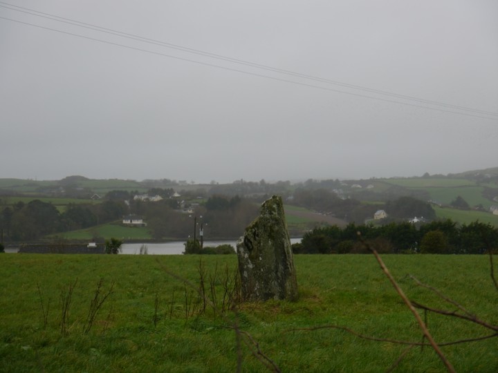
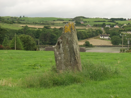
Rosscarbery (Standing Stone / Menhir) on The Modern Antiquarian, the UK & Ireland's most popular megalithic community website. 3 images, 1 fieldnote, plus information on many more ancient sites nearby and across the UK & Ireland.
Image © Alan S>
Nearest Town:
Ross Carbery (1km W)
OS Ref (IE):
W295361 /
Sheet: 89
Latitude:
51° 34' 23.67" N
Longitude:
9° 1' 1.2" W
Added by
ocifant
Images (3)
Fieldnotes (1)
0 discussions
Start a topic
Show |
Hide
Web searches for Rosscarbery
Flickr
Google
Google Images
The Megalithic Portal
Bing
Stone Pages
Wikipedia
Show map
(inline Google Map)
- Sites within 20 km -
-
Burgatia (0.74km NE) (5 posts)
Ahaglaslin (1.21km ENE) (3 posts)
Bohonagh (1.47km ENE) (45 posts)
Tinneel (2.09km NNW) (8 posts)
Curraheen (2.11km WSW) (3 posts)
Derryduff (3.35km NE) (4 posts)
Lettergorman (South) (3.49km WSW) (39 posts)
Freahanes (4km NNW) (7 posts)
Drombeg (4.87km WSW) (70 posts)
Killacoosane (5.71km WSW) (6 posts)
Reanascreena (5.73km WNW) (46 posts)
Coorleigh South (6.21km ENE) (9 posts)
Galley Head (6.35km ESE) (3 posts)
Sarue (6.86km NNW) (7 posts)
Tullig Stone (7.14km WNW) (3 posts)
Ballyroe (7.74km W) (8 posts)
Ballyvackey (8.12km NE) (30 posts)
Carrigagrenane SW (8.19km NW) (9 posts)
Knocks S (8.22km N) (18 posts)
Carrigagrenane NE (8.38km NW) (7 posts)
Ahaghilla (8.44km NNE) (13 posts)
Carrigillihy (8.61km WSW) (6 posts)
Knockatlowig (8.64km NNE) (10 posts)
Carrigillihy (8.69km WSW) (9 posts)
Maulatanavally (8.69km NW) (26 posts)
Glanbrack (8.7km NW) (15 posts)
Knocks (8.75km N) (13 posts)
Inchinattin (8.79km NNW) (2 posts)
Maulatanvally (9.05km NW) (8 posts)
Knocks (9.12km N) (2 posts)
Gurteenaduige (9.34km W) (8 posts)
Knocks N (9.54km N) (20 posts)
Killinga (9.78km W) (6 posts)
Coolnaconarty (9.82km N) (9 posts)
Cashelisky (10.07km NE) (9 posts)
Knockawaddra E (10.08km NNW) (15 posts)
Knockawaddra W (10.17km NW) (17 posts)
Letter (site E) (10.58km NE) (11 posts)
Milleennagun (11.41km NNW) (3 posts)
Milleennagun (11.46km NNW) (12 posts)
Lettergorman (North) (11.53km NW) (25 posts)
Garrygalss (11.58km WNW) (0 posts)
Garryglass (11.6km WNW) (3 posts)
Templebryan (12.03km NE) (0 posts)
Caherkirky (12.04km N) (11 posts)
Templebryan (12.05km NE) (23 posts)
Reavouler (12.07km WNW) (14 posts)
Ahidelake (12.51km E) (3 posts)
Gurranes (12.81km WSW) (25 posts)
Knockdrum (13.27km WSW) (12 posts)
Darrary (13.46km ENE) (4 posts)
Lisnagun (13.46km ENE) (7 posts)
Knocks (East) (14.17km NNE) (7 posts)
Ballyhalwick (16.54km NW) (3 posts)
Nedinagh West (16.62km NNW) (3 posts)
Coolnagarrane (16.74km WSW) (2 posts)
Baurnahulla (18.02km W) (3 posts)
Barryshall (18.02km ENE) (7 posts)
Dunmanway North (18.11km NW) (5 posts)
Shronacarton (18.53km WNW) (6 posts)
Abbeystrowry (18.96km WSW) (5 posts)
Toom (19.2km NNW) (4 posts)
Derrynasafagh (19.23km NW) (3 posts)
Lissangle (19.31km W) (5 posts)
Kinneigh (19.63km N) (5 posts)
Clodagh Row (19.82km WNW) (12 posts)
Clodagh (19.82km WNW) (19 posts)
- Add -
-
Add news
Add an image
Add fieldnotes
Add folklore
Add miscellaneous
Add a link
-
Add a site
Add a nearby facility
Add an alternative name/spelling
Images
(click to view fullsize)
Add an image
Fieldnotes
Add fieldnotes
This stone is easily visible from the N25 heading into Rosscarbery from the east, although it actually took us several days before we found it, spending most of our week either west or north of Rosscarbery.
This post appears as part of the weblog entry
Ireland Excursion - Pt 5
Comments (0)
|
Add a comment
|
Permalink
Posted by
ocifant
9th July 2003ce