This was a cleanup day around South London, visiting a few sites that I hadn't before. I had a good day for it and some pleasant company, so the day was an undoubted success. We did a loop from West to East, starting at Diana's Dyke, then Gally Hills, Croham Hurst and finally attempted to get onto Caesar's Camp.
Having done my list within the M25 and it was only 3pm, we headed outside to North Kent. First up was Squyerres Park but another nono, so we finished up at Oldbury again which is rapidly becoming a fav of mine.
All in all a nice productive day.
A quick word though, if you intend to do this South London wander, make sure you take in Morden Park at the start and Chislehurst Caves & Winn's Common at the end. Actually, depending on your start time, you might want to reverse the route as well. That way you can be first in to Chislehurst caves & set up the day nicely.
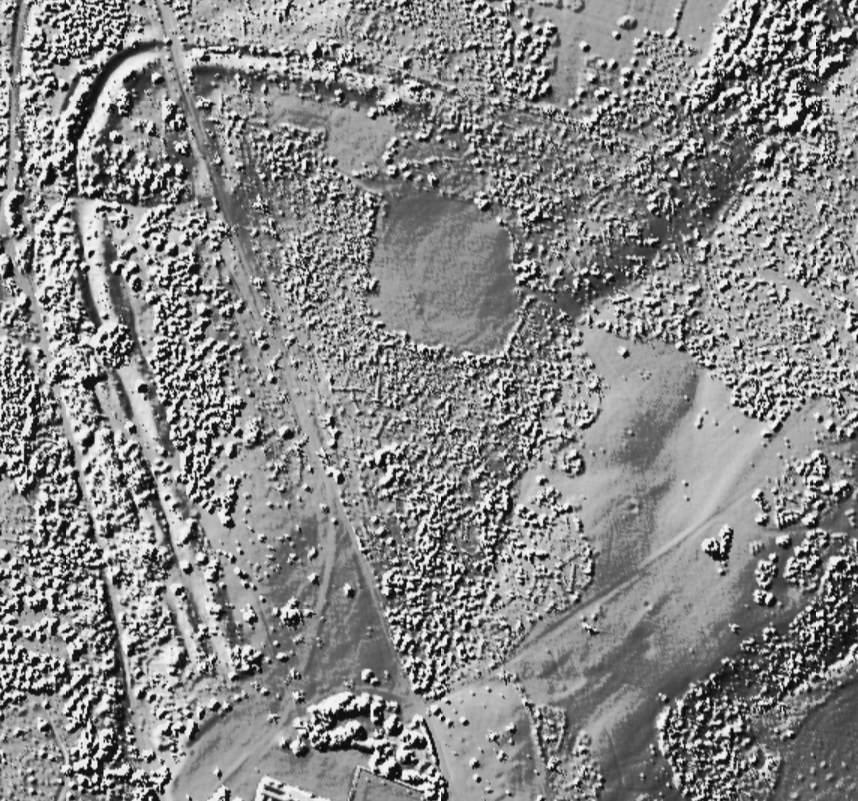
Caesar's Well, the chief source of the Ravensbourne, is situated near the entrance gates to Holwood Park. Mr Hone's interesting "Table Book," written in the year 1828, contains an account of a visit paid, in company with his friend W--, to the source of the Ravensbourne. At the time of that visit it would appear that the spring was known locally as the "Bath." In the time of Mr Pitt's residence at Holwood it was much used as a bath, and its waters were supposed to be possessed of valuable medicinal properties. Hasted's plan of the camp at Holwood (pub. in 1778) shows the well or bath, and twelve trees are represented as growing close round its margin, and there are appearances of steps leading down to the water.
[..] The name Ravensbourne is commonly supposed to take its origin from the following tradition. When the Roman soldiers were encamped at Holwood there was great need of water. A raven was seen to frequent a certain spot near the camp, and upon close examination a small spring was discovered among the bushes. Upon digging out the place a copious spring was found, and from the accident which led to that discovery it is supposed the stream took its name.
Definitely some confusion - a raven would definitely help the native Britons, not the Romans! And of course the camp is not Roman at all, though that's surely what I believed when I went paddling about in this spring as a kid. Only parts of the camp's ramparts remain. There is a gap on the western side near the spring: the record on Pastscape seems to imply this was the main entrance.
From Antiquarian Jottings relating to Bromley, Hayes, Keston and West Wickham, in Kent, by George Clinch (1889).
‘The Archaeology of the Bromley Area’ (Kent Archaeological Rescue Unit – 1985) reports that “…by about 200 BC a very large and powerful tribe dominated the area with a territory probably reaching to the River Thames. Unfortunately, its name and its chieftains are not known! Such were its resources in terms of manpower and organization that it was able to construct a massive hillfort at Holwood Park, Keston, covering an area of about 43 acres. Here large numbers of tribesmen and women would have been required to construct the massive multiple ramparts and ditches which in places topped 40ft and ran for a mile in circumference. Although much of the fences were thrown down in the 18th Century, it still rates a one of the most spectacular prehistoric sites in Kent. It is protected as a Scheduled Ancient Monuments and lies within private grounds. Minor excavations took place here many years ago, but the interior has never been excavated”.
This publication also has two good diagrams of the site. The surviving defences are univallate (i.e. a one bank and ditch) on the North side, and bivallate (i.e. two banks and ditches) on the West side. The north west section also shows an entrance. The rest of the defences have been flattened.

 Posted by juamei
 Posted by Rhiannon
 Posted by pure joy