|
|

|
|
Hutton Moor HengeHenge
|
||||||||||||||||||||||||
|
|
|
Images (click to view fullsize) |
|
|
Fieldnotes |
|
|
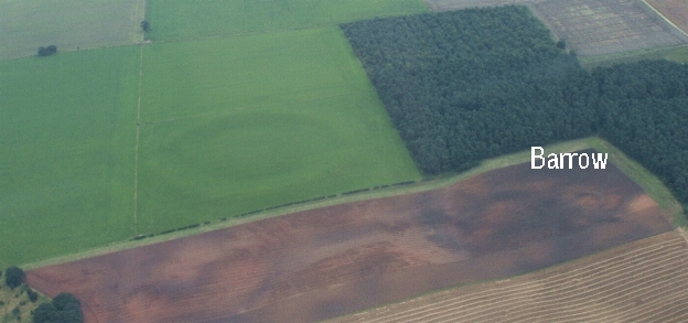
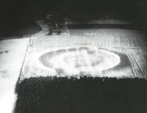
Hutton Moor Henge (Saturday, 22.11.03) This is a beauty. If approaching from the north, you can drive some way up the farm track which starts at Hutton Moor House, till mud takes over. Then, on foot, bear left past the silage tank, and the grass track (mostly following the energy line) will take you to the henge. On high ground and with a backdrop of woodland, Hutton Moor Henge stands wide and noble, protected by wire fences but with easy access by gate. The banks are low nowadays but they are green and shapely. Using a pair of dowsing rods, I found the main energy line runs right through the centre in a NNWSSE direction, 18 paces wide (= about 9 yards). It seems to colour the grass along its route in a sandwich pattern, making darker tracks along its outer portions and a lighter track between them. It avoided the apparent entrances (extended dips) because they were aligned NS. However, there was a strange little extra energy line, only a foot or two wide, running through the north entrance, making a light coloured track. I did not follow this (nor the main energy line) to the southern part of the henge as somebody with a very loud gun was killing things in the woods and a stray bullet did not seem impossible. (Is November 22nd special? There seemed to be distant guns going off in all directions.) The apparent effect on the grass, by the way, has an approximate parallel at Thornborough Henges, where the energy line, on leaving the central henge in a NW direction, cuts a channel (sheep track?) through the grass as it goes. This track, though very narrow, seems precisely at the centre of the energy flow. A Note On Dowsing Anyone can dowse. Hold two bent metal sticks (cut, say, from a coat hanger) one in each hand and walk slowly, pointing them forward like six shooters, till they decide to cross of their own volition. You have then found an energy line. After a number of paces (say, seven or ten or sixteen) the sticks will uncross, and you have then found the width of the energy line. Try the same procedure at a few other points and, with luck, you will have found the direction of the energy line, which can then be checked with a compass. The good thing about energy dowsing is that we are able to connect with the minds of the Old People. Neither brutal nor ignorant, they aligned their monuments meaningfully, and with a pair of bent metal rods we can follow their thinking. We can connect with the same energy they did, and by so doing, we can connect with them. This feels good: real field work. |
Posted by Gerry Fenge 24th November 2003ce Edited 25th November 2003ce |
Miscellaneous |
|
|
Details of henge on Pastscape SE 3526 7353: Earthen Circle [O.E.] (1) SE 353 735: Hutton Moor. North Circle. (2) SE 352 735: Henge monument class IIA. (3) The earthwork has been considerably reduced and denuded by modern ploughing but despite this the published survey (25 1912) remains correct. This cultivation which is still in operation is further reducing and spreading the circular bank and internal ditch and although these features are still substantial in height their limits are now poorly defined. A slight but wide external depression is traceable around the entire earthwork except at the north and south entrances where a well spread causeway leading from the central platform crosses it. These latter features are not surveyable and have been annotated on the 25" survey. (4) SE 3525 7353: Entry in corpus; No 209. Classic henge with bank lying between two ditches. Ditch terminals are roughly squared. Internal diameter range circa 93-96 metres, external diameter range circa 240-254 metres, inner ditch circa 10-18 metres wide (estimated from transcription). Orientation north north west to south south east. Raistrick excavated parts of the inner ditch before 1929. (5) SE 3525 7352: Henge monument 500 metres north west of Low Barn. Scheduled RSM No 25578. The bank is 45 metres wide and stands to a max height of 3 metres. The inner ditch, which remains as a slight hollow, is 5 metres wide. The inner enclosure has a diameter of 80 metres. The overall external diameter is as stated by Authority 5. There are two entrances at the north and south, formed by access causeways. The monument is crossed by two modern fence lines. (6) This henge comprises several elements. An inner ditch circuit (c. 10-12m wide) of sub-circular plan with a maximum diameter of 100m. Some photos show the inner ditch to be discountinuous but others do not but this may indicate that the depth of the ditch varies around the circuit. The cropmarks suggest there is a possible pit within the north-west quadrant of the inner area and there is slight evidence for an internal bank. The inner ditch circuit has opposed entrances facing to the north and to the south. Surrounding the ditch is an outer bank, which sits on the berm between the inner ditch and a second outer ditch. The berm is some 50m wide and bank material appears to be spread across it on many of the air photos, but the 1973 photos indicated that the original base of the bank was only 15-17m wide and was situated near the middle of the berm. There are two entrances in the bank, both aligned with those in the inner ditch. The outer-most ditch is less regular in width, measuring between 6m and 16m it too has entrances aligned with those in the inner ditch. The outer ditch terminals are notably square, the bank terminal appear slight flared and higher than the rest of the bank ring, whilst the inner ditch terminals are more rounded. The western edge of the outer ditch is clipped by a modern field boundary. 2007 and 2009 air photos suggest this monument does still survive as low earthworks. (7-12) |
 Posted by Chance
28th December 2014ce |
[There is] a remarkable earth-work on the high land near "Blois hall," commanding extensive prospets up and down the Vale of Ure, as well as of the distant ranges of hills which form the side screens of the great Yorkshire plain.Page 4 in 'A guide to Ripon, Harrogate, Fountains Abbey, Brimham Rocks..' by John Walbran (1856), which you can read at Google Books. |
 Posted by Rhiannon
27th October 2007ce |