The Modern Antiquarian
Log in
|
Register
Home
Latest Posts
Forums
Maps
Help
Browse Sites
News
Blog
Contributors
The Books
Select
-
Belgium
Denmark
Eire
France
Germany
Greece
Italy
The Netherlands
Norway
Portugal
Republic of Malta
Spain
Sweden
Switzerland
United Kingdom
England
Southern England
Cornwall
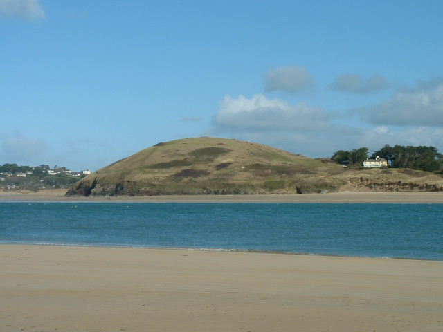
Brea Hill
Round Barrow(s)
Brea Hill (Round Barrow(s)) on The Modern Antiquarian, the UK & Ireland's most popular megalithic community website. 1 image, plus information on many more ancient sites nearby and across the UK & Ireland.
Image © phil
Nearest Town:
Padstow (5km SE)
OS Ref (GB):
SW928771 /
Sheet: 200
Latitude:
50° 33' 22.51" N
Longitude:
4° 55' 32.02" W
Added by
phil
Images (1)
0 discussions
Start a topic
Show |
Hide
Web searches for Brea Hill
Flickr
Google
Google Images
MAGIC
The Megalithic Portal
Bing
Stone Pages
Streetmap.co.uk
Wikipedia
Show map
(inline Google Map)
- Sites within 20 km -
-
The Rumps (3.94km N) (8 posts)
Harlyn Bay (5.42km WSW) (5 posts)
Constantine Church stone (7.12km WSW) (10 posts)
Dinas Head (8.03km WSW) (3 posts)
Bogee Farm (8.07km S) (1 post)
Fox Cove (8.12km WSW) (4 posts)
Winecove Point (8.15km WSW) (13 posts)
Pawton Quoit (8.39km SE) (35 posts)
Porthcothan Fogou (8.54km SW) (2 posts)
Rowan Cove (8.61km SW) (4 posts)
The Long Stone (8.67km S) (14 posts)
Bogee Barrow A (8.78km S) (2 posts)
Higher Trevibban (8.81km S) (1 post)
Pawton Springs (8.89km SE) (19 posts)
Magi Stone (8.96km SSE) (7 posts)
Pawton Gate (9.18km SE) (12 posts)
Bogee Barrow B (9.21km S) (4 posts)
Rosenannon Downs W (9.27km SE) (6 posts)
Rosenannon Downs (9.39km SE) (17 posts)
The Nine Maidens (9.53km SSE) (65 posts)
Men Gurta (9.65km SE) (46 posts)
St. Eval Church Stones (9.66km SW) (14 posts)
St Breock Beacon Kistvaen (9.7km SE) (19 posts)
Kelly Rounds (9.72km E) (4 posts)
St Breock Downs North Barrows (9.76km SE) (21 posts)
Pennatillie (9.85km S) (1 post)
Treburrick Menhir (9.88km SW) (5 posts)
Prince Parc (9.89km S) (1 post)
St Breock Downs Menhir (9.96km SE) (24 posts)
Park Head cemetery (10.07km SW) (17 posts)
St Breock Wind Farm Barrow (10.09km SE) (9 posts)
Trevisker Round (10.44km SW) (4 posts)
Park Head fort (10.67km SW) (7 posts)
St. Eval Airfield Stone (10.72km SSW) (14 posts)
Tregeare Rounds (10.85km ENE) (2 posts)
Redcliff Castle (10.94km SW) (9 posts)
Higher Tregolls (11.64km SE) (1 post)
High Cove (11.88km SW) (4 posts)
Pencarrow Rings (13.22km E) (6 posts)
Griffin's Point (13.7km SW) (9 posts)
Longstone (St Mabyn) (13.73km E) (5 posts)
Treligga Common (14.4km NE) (9 posts)
Castle-an-Dinas (St. Columb) (14.78km SSE) (35 posts)
Penhargard Castle (14.81km E) (3 posts)
Lower Helland Down (14.9km E) (2 posts)
Devil's Quoit (15.19km SSE) (11 posts)
Helsbury Castle (15.64km ENE) (7 posts)
Castle Goff (16.3km ENE) (1 post)
Whipsiderry (16.35km SW) (17 posts)
Deep Tye Farm (16.45km SSE) (1 post)
Tregoss Moor (16.47km SE) (1 post)
Melancoose Round (16.65km SSW) (2 posts)
St. Materiana Church Yard (16.73km NE) (5 posts)
Tintagel (17km NE) (18 posts)
Black Barrow (17.19km ESE) (1 post)
Trevelgue Head (17.43km SW) (20 posts)
Lady Down (St Breward) (17.55km E) (3 posts)
Castilly Henge (17.67km ESE) (7 posts)
Devil's Jump (17.67km ENE) (7 posts)
Menevagar Longstone (17.97km SE) (12 posts)
Bossiney Mound (17.98km NE) (3 posts)
Council Barrow (18.34km E) (3 posts)
Barrowfields (18.37km SW) (19 posts)
Delford Bridge Menhir (18.38km E) (15 posts)
Willabury (Tintagel) (18.42km NE) (4 posts)
Roche Rock (18.57km SE) (36 posts)
Kerrow Downs (18.74km E) (5 posts)
Treswallock Downs (18.74km ENE) (23 posts)
Polgoda Stone Row (18.86km ESE) (1 post)
Rocky Valley Rock Carvings (18.9km NE) (15 posts)
Alex Tor (19.01km ENE) (10 posts)
St Dennis (19.02km SSE) (8 posts)
Condolden Barrow (19.03km NE) (11 posts)
Moorgate Menhir (19.07km ENE) (17 posts)
King Arthur's Quoit (19.33km NE) (4 posts)
Castle Canyke (19.37km ESE) (4 posts)
Casehill Cairn (19.74km ENE) (9 posts)
Manor Common (19.91km E) (19 posts)
Stannon (19.94km ENE) (72 posts)
Slaughter Bridge Stone (19.98km ENE) (9 posts)
Trehudreth Downs Menhir (19.99km E) (8 posts)
- Facilities within 20 km -
-
Treyarnon Bay (Youth Hostel: 7.5 km SW)
Tintagel (Youth Hostel: 16.3 km NE)
The Blisland Inn (Pub: 17.5 km E)
Newquay Youth Hostel (Youth Hostel: 18.6 km SSW)
Masons Arms (Pub, Rest... (Pub: 18.8 km ENE)
Travel Inn (Motor Lodge: 19.9 km S)
- Add -
-
Add news
Add an image
Add fieldnotes
Add folklore
Add miscellaneous
Add a link
Add a nearby facility
Add an alternative name/spelling
Images
(click to view fullsize)
Add an image
 Image © phil