|
|

|
|
Cocklawburn Beach RingsNatural Rock Feature
|
||||||||||||||||||||||||
|
|
|
Images (click to view fullsize) |
|
|
Fieldnotes |
|
|
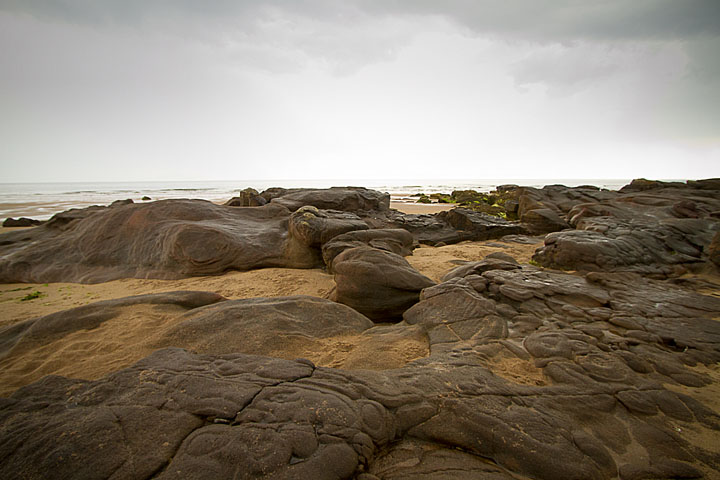
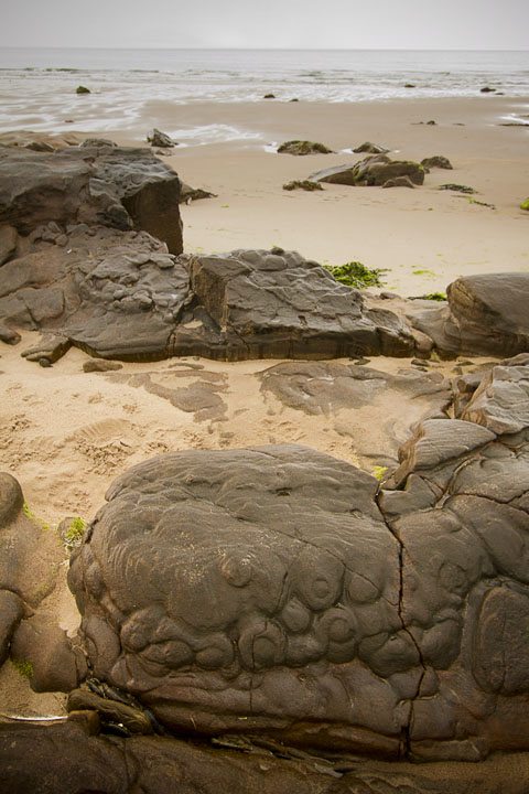
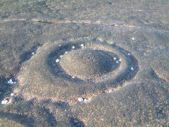
So after 11 years, I finally managed to get here to check out Moey's find. I took the long walk from the north end of the beach, passing the old lime kilns that are half fallen into the sea, so I would be able to have a gander at the other stretches of rock, and none of them had the rings. The rings themselves are on a fairly small patch of rocks, and looking at my photos, I'm not sure I found exactly the same ones as Moey, but it was definitely the same patch of rocks. Perhaps over the last decade, sand has shifted, or seaweed covered/uncovered some of the rings. It's got to be a fairly slim chance that these things inspired the creators of the CnRs in the area, as the seashore would have been a lot further out back then, but hey, if there are such rings here, maybe there were others which are now much further out. That still doesn't explain the ones to be found further afield, but I would like to think that the CnR carvers might have seen natural structures like these and incorporated them into the mythos of the rings. |
 Posted by Hob
27th July 2014ce |
|
HOW TO GET THERE From Berwick Upon Tweed Head towards the A1 (Southwards) Before you reach the A1, turn left towards the village of Scremerston. Immediately turn left again and follow the road round. At Borewell Farm (offering farm shop etc) take another left. cross the railway and continue along the road until it falls away into disrepair. park up below the "pill box" and walk through the nature reserve part of the dunes. you will come to a fence, climb it and follow the path down to the beach. It is pretty rough and steep going, but soon you will be on a sandy beach. Keep close to the dunes and look out for rocks that are submerged at high tide. These are the ones you need to examine. Apologies if the grid reference is not 100% correct. If you have any problems finding it - give me a shout! Moey |
 Posted by moey
16th January 2003ce Edited 16th January 2003ce |
|
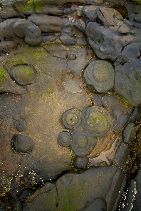
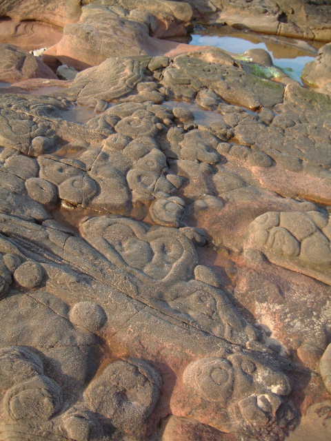
ART IMITATES LIFE This area was something that caught me by surprise. On the beach at Cocklawburn near Berwick-Upon-Tweed Lie some excellent rock formations that look similar to cup and ring marks. I used to walk my dogs here a lot and had never noticed them beforee, but one day I was walking with my head down and say one of the ring formations. I couldn't believe it - didn't know if they were natural or man made. I looked around and there were loads of them. Some qute large, but many were huddled together on rocky outcrops like so many limpets hanging on for dear life. Many are flat to the surface of the sand, but others are vertical on the rocks. I formulated a theory about sandstone and volcanic rock fusing, but this doesn't seem to be quite right. Through the wonders of the community that is Head Heritage, I got talking to Fitzcoraldo about rock art, I sent him the pics and he showed them to the resident geologists on his oil rig. I hope Fitz doesn't mind me reprinting his reply, but this is the current thinking on the formations. "I have a name for your bizarre rock formation and can tell you that your half baked theory was only a quarter baked. I've consulted the afternoon shift geologists and the consensus seems to be that they are a phenomena called MUD VOLCANOES, in fossil form of course. Apparently you get mud volcanoes in areas like large river deltas, where you get a large amount of sediment deposited quickly, this mud is then overlain by slower deposited sands which compress the mud causing it to flow upwards inna volcano stylee. So there you go." |
Posted by moey 16th January 2003ce |
Miscellaneous |
|
A mile to the southeast was a massive cairn, which yielded finds but is now gone. From pastscape:(centred NU 039470) A tumulus of water-worn stones, about 26 feet high and 50 feet diameter, stood about 250 yards from High Water Mark, on the very extreme limit of the cultivated land, on the left of the road from Cheswick to the beach. When opened in 1826, it was found to contain several secondary inhumations, and, at its centre, a primary burial in a cist, 5 feet x 2 feet 6 inches, together with a bronze knife-dagger, now in the B.M. |
 Posted by thesweetcheat
7th April 2019ce |