The Modern Antiquarian
Log in
|
Register
Home
Latest Posts
Forums
Maps
Help
Browse Sites
News
Blog
Contributors
The Books
Select
-
Belgium
Denmark
Eire
France
Germany
Greece
Italy
The Netherlands
Norway
Portugal
Republic of Malta
Spain
Sweden
Switzerland
United Kingdom
England
Northern England
Staffordshire
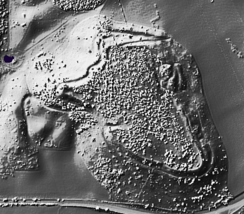
Berth Hill
Hillfort
Berth Hill (Bryth Hill/The Bruff) (Hillfort) on The Modern Antiquarian, the UK & Ireland's most popular megalithic community website. 1 image, plus information on many more ancient sites nearby and across the UK & Ireland.
Image © Open Source Environment Agency LIDAR
Also known as:
Bryth Hill
The Bruff
Nearest Town:
Newcastle-U-Lyme (9km NNE)
OS Ref (GB):
SJ788391 /
Sheet: 127
Latitude:
52° 56' 54.49" N
Longitude:
2° 18' 55.99" W
Added by
stubob
Images (1)
0 discussions
Start a topic
Show |
Hide
Web searches for Berth Hill
Flickr
Google
Google Images
MAGIC
The Megalithic Portal
Bing
Stone Pages
Streetmap.co.uk
Wikipedia
Show map
(inline Google Map)
- Sites within 20 km -
-
The Auctioneers Mound (3.56km SW) (3 posts)
Bishop's Wood Hillfort (7.02km SW) (1 post)
The Devil's Ring and Finger (8.18km WSW) (28 posts)
Saxons' Lowe (9.02km E) (1 post)
Bury Bank (9.99km E) (3 posts)
The Roundabout (15.23km SSE) (1 post)
Norbury (15.28km SSE) (2 posts)
Church Lawton (16.81km N) (6 posts)
Cat Low, Dilhorne (18.92km ENE) (2 posts)
Gawton's Stone (19.61km NE) (13 posts)
Gawton's Well (19.69km NE) (7 posts)
Old Man O'Mow (19.74km NNE) (9 posts)
- Facilities within 20 km -
-
The Potteries Museum &... (Museum: 12.8 km NE)
- Add -
-
Add news
Add an image
Add fieldnotes
Add folklore
Add miscellaneous
Add a link
-
Add a site
Add a nearby facility
Add an alternative name/spelling
Images
(click to view fullsize)
Add an image