The Modern Antiquarian
Log in
|
Register
Home
Latest Posts
Forums
Maps
Help
Browse Sites
News
Blog
Contributors
The Books
Select
-
Belgium
Denmark
Eire
France
Germany
Greece
Italy
The Netherlands
Norway
Portugal
Republic of Malta
Spain
Sweden
Switzerland
United Kingdom
England
Southern England
Isles of Scilly
Gugh
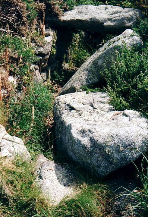
Obadiah's Barrow
Entrance Grave
Obadiah's Barrow (Entrance Grave) on The Modern Antiquarian, the UK & Ireland's most popular megalithic community website. 1 image, 1 fieldnote, plus information on many more ancient sites nearby and across the UK & Ireland.
Image © Earthstepper
Nearest Town:
Newlyn (61km ENE)
OS Ref (GB):
SV887085 /
Sheet: 203
Latitude:
49° 53' 41.66" N
Longitude:
6° 20' 7.38" W
Added by
Rhiannon
Images (1)
Fieldnotes (1)
0 discussions
Start a topic
Show |
Hide
Web searches for Obadiah's Barrow
Flickr
Google
Google Images
MAGIC
The Megalithic Portal
Bing
Stone Pages
Streetmap.co.uk
Wikipedia
Show map
(inline Google Map)
- Sites within 20 km -
-
Old Man of Gugh (0.31km E) (5 posts)
Clapper of Works (0.63km ESE) (1 post)
South Hill (0.64km ESE) (1 post)
Carn of Works (0.66km ESE) (1 post)
Nag's Head (0.89km SSW) (4 posts)
Wingletang Down (1.07km SSW) (1 post)
Porthcressa cist-grave cemetry (2.35km NE) (1 post)
Peninnis Head (2.51km ENE) (9 posts)
Peninnis Head (2.52km ENE) (15 posts)
Buzza Hill (2.68km NE) (30 posts)
Harry's Walls (3.25km NE) (11 posts)
Airport cairn (3.79km ENE) (5 posts)
South Hill (3.99km NW) (5 posts)
Giant's Castle (4.07km ENE) (12 posts)
Salakee Down (4.14km ENE) (24 posts)
Bant's Carn (4.43km NNE) (32 posts)
Halangy Down (4.57km NNE) (21 posts)
North Hill (4.7km NW) (6 posts)
Porth Hellick Downs (4.72km ENE) (33 posts)
Long Rock (4.73km NNE) (9 posts)
The Great Tomb on Porth Hellick Down (4.77km ENE) (49 posts)
Mount Todden (5.11km NE) (6 posts)
Normandy Down (5.2km NE) (26 posts)
Lyonesse (5.29km NNW) (4 posts)
Innisidgen Lower (5.33km NE) (27 posts)
Innisidgen (5.38km NE) (32 posts)
Works Cairn (5.66km NNW) (9 posts)
St Nicholas's Priory (5.73km N) (3 posts)
Samson Hill entrance grave (5.76km NNW) (1 post)
Samson Hill Cairns (5.76km NNW) (1 post)
Hillside Farm (6.54km NNW) (2 posts)
Gweal Hill (6.58km NW) (3 posts)
Shipman Head Down (7.17km NNW) (2 posts)
Great Arthur (7.41km NE) (7 posts)
Middle Arthur Boat Shaped Passage Grave (7.47km NE) (3 posts)
Little Arthur (7.54km NE) (4 posts)
Shipman Head Down (7.67km NNW) (2 posts)
Castle Down (7.79km NNW) (14 posts)
Cruthers Hill (7.97km NNE) (1 post)
Old Man (8.01km N) (1 post)
West Porth (8.04km N) (1 post)
Knackyboy Cairn (8.12km NNE) (1 post)
Higher Town (8.19km NNE) (1 post)
Great Hill (8.38km N) (1 post)
Nornour (8.4km NE) (4 posts)
Tinkler's Hill (8.43km NNE) (1 post)
Menawethan (8.53km NE) (2 posts)
Burnt Hill (8.94km NNE) (1 post)
Chapel Downs (9.2km NE) (2 posts)
White Island (9.8km NNE) (2 posts)
- Facilities within 20 km -
-
Buccabu Bike Hire (Tourist Information: 2.5 km NNE)
- Add -
-
Add news
Add an image
Add fieldnotes
Add folklore
Add miscellaneous
Add a link
Add a nearby facility
Add an alternative name/spelling
Images
(click to view fullsize)
Add an image
Fieldnotes
Add fieldnotes
An angled passage of about 16ft leads to the chamber. Two of the six capstones have collapsed leaving the site in a delightfully unrestored state. Excavations revealed a male skeleton, ashes and twelve inverted urns.
Comments (0)
|
Add a comment
|
Permalink
Posted by
Earthstepper
2nd September 2003ce