The Modern Antiquarian
Log in
|
Register
Home
Latest Posts
Forums
Maps
Help
Browse Sites
News
Blog
Contributors
The Books
Select
-
Belgium
Denmark
Eire
France
Germany
Greece
Italy
The Netherlands
Norway
Portugal
Republic of Malta
Spain
Sweden
Switzerland
United Kingdom
England
Southern England
Cornwall
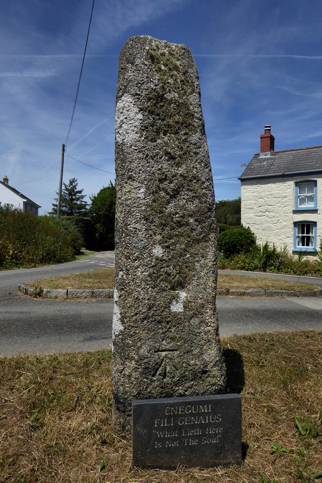
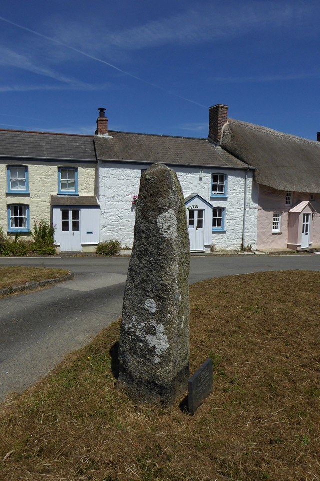
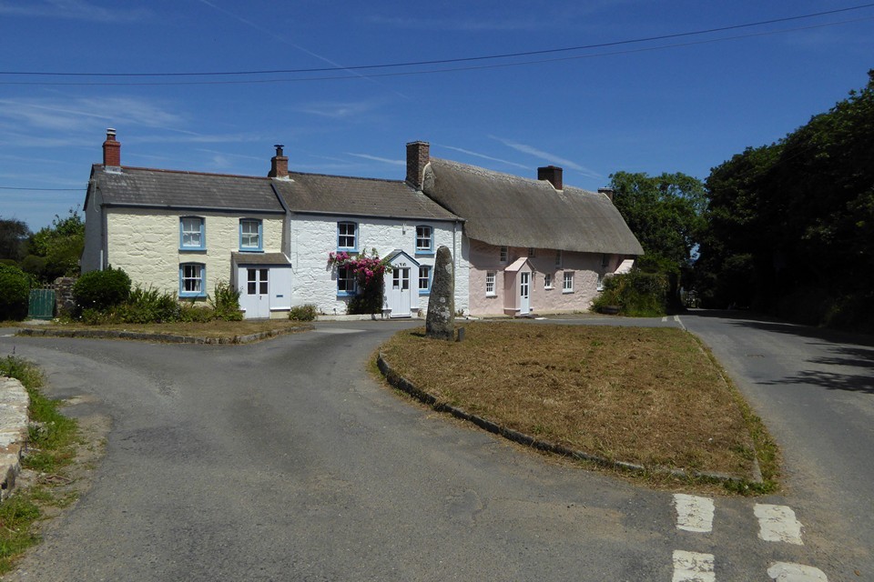
Mawgan Cross
Christianised Site
Mawgan Cross (Christianised Site) on The Modern Antiquarian, the UK & Ireland's most popular megalithic community website. 4 images, plus information on many more ancient sites nearby and across the UK & Ireland.
Image © A. Brookes (25.6.2018)
This site is of disputed antiquity. If you have any information that could help clarify this site's authenticity, please post below or
leave a post in the forum
.
Nearest Town:
Mullion (6km S)
OS Ref (GB):
SW7071224869 /
Sheet: 203
Latitude:
50° 4' 44.35" N
Longitude:
5° 12' 18.74" W
Added by
thesweetcheat
Images (4)
0 discussions
Start a topic
Show |
Hide
Web searches for Mawgan Cross
Flickr
Google
Google Images
MAGIC
The Megalithic Portal
Bing
Stone Pages
Streetmap.co.uk
Wikipedia
Show map
(inline Google Map)
- Sites within 20 km -
-
Halliggye Fogou (1.19km ESE) (53 posts)
Gear (1.38km E) (1 post)
Caer Vallack (1.82km E) (1 post)
Boskenwyn Down (2.67km NW) (1 post)
Tolvan Holed Stone (2.83km NNW) (27 posts)
Dry Tree Menhir (4.17km SE) (29 posts)
Goonhilly Down (4.17km SE) (16 posts)
Crasken Round (4.55km WNW) (0 posts)
Traboe (4.88km ESE) (3 posts)
Trewardreva Fogou (5.53km NNE) (26 posts)
Higher Boden Fogou (5.83km E) (8 posts)
Higher Boden Roundhouse (5.83km E) (1 post)
Mullion Towans (6.39km SW) (6 posts)
Halzephron Cliff (6.54km SW) (5 posts)
Wendron Mortar Outcrop (7.14km NW) (5 posts)
Garland Round (7.25km W) (0 posts)
Tolmen Stone (Constantine) (7.27km NNE) (9 posts)
Three Brothers of Grugith (7.38km ESE) (24 posts)
Roskruge Beacon (7.43km E) (0 posts)
Eathorne Menhir (7.5km NNE) (7 posts)
Little Dennis (8.02km ENE) (9 posts)
Tremenhere Menhir (8.05km E) (13 posts)
Prospidnick Longstone (8.17km WNW) (8 posts)
St Keverne Beacon (8.29km ESE) (0 posts)
Crousa Common Menhirs (8.41km ESE) (11 posts)
Hervan Menhir (8.43km S) (3 posts)
Little Kistles (8.5km ESE) (0 posts)
Higher Spargo (8.55km NNE) (2 posts)
Poldowrian (8.94km SE) (3 posts)
Mabe Church (9.01km NNE) (13 posts)
Men Amber (9.27km WNW) (11 posts)
Lankidden (9.54km SE) (12 posts)
Burras Menhir (9.92km NW) (13 posts)
Giants Quoits (10.35km E) (7 posts)
Stithians Cupmarked Stones (10.53km N) (5 posts)
Calvadnack Settlement (10.75km NNW) (1 post)
Chynhalls Point (10.76km ESE) (11 posts)
Lowland Point (10.78km E) (7 posts)
Crowan Beacon (10.99km NW) (1 post)
Camel Rock (11.02km W) (6 posts)
Kynance Gate Settlement (11.12km S) (10 posts)
Trewavas Cliff (11.15km W) (17 posts)
Tregonning Hill (11.33km W) (11 posts)
Drym Round (11.47km WNW) (0 posts)
Tregear Round (11.55km WNW) (0 posts)
Carnmenellis (11.58km NNW) (7 posts)
The Rill (11.83km S) (7 posts)
Nine Maidens (Troon) (11.86km NNW) (36 posts)
Castle Pencaire (11.92km W) (28 posts)
Hangman's Barrow (12.29km NW) (12 posts)
Stithians Menhir (12.63km NNE) (5 posts)
Godolphin Hill (13.09km W) (8 posts)
Carwynnen Quoit (13.56km NW) (60 posts)
Four Lanes barrows (13.68km NNW) (4 posts)
Carvannel Menhir (13.82km NNW) (6 posts)
Trebowland Round (13.98km N) (2 posts)
Gear Round (14.65km WNW) (0 posts)
Carn Brea (15.99km NNW) (33 posts)
Cudden Point (16.06km W) (2 posts)
The Hood (16.21km NW) (3 posts)
Castle Kayle (16.36km WNW) (0 posts)
Maen Cadoar (16.37km NW) (5 posts)
Treveneague Fogou (17.03km W) (2 posts)
St Erth Round (17.87km W) (0 posts)
Connor Downs (17.89km WNW) (0 posts)
Carnsew (19.37km WNW) (9 posts)
Phillack Towans (19.52km WNW) (5 posts)
St. Michael's Mount (19.88km W) (27 posts)
Tehidy Round (19.9km NW) (6 posts)
- Facilities within 20 km -
-
Coverack (Youth Hostel: 10.2 km ESE)
- Add -
-
Add news
Add an image
Add fieldnotes
Add folklore
Add miscellaneous
Add a link
Add a nearby facility
Add an alternative name/spelling
Images
(click to view fullsize)
Add an image