|
|

|
|
ClonasillaghPassage Grave
|
||||||||||||||||||||||||
|
|
|
Sites in this group:
|
5 posts
Clonasillagh Cairn Cairn(s) |
5 posts
Clonasillagh Decorated Stone Cup and Ring Marks / Rock Art |
Images (click to view fullsize) |
|
|
Miscellaneous |
|
|
From archaeology.ie: This has been described by Eogan (2000, 11-13) as follows: ‘This is also situated on a knoll and is very overgrown. The knoll, which is much higher than the adjacent features, is rounded and somewhat pudding-bowl in shape, and as such it contrasts with the other knolls in the area which are long Bakers. In Prof. Phillips' opinion it is "probably a kame deposited in a lake by melt water flowing out from a glacier during the last ice age c. 22,000-14,000 years ago." The view is slightly more extensive than that from Site 2 [ME010-044----] and portions of Slieve na Calliagh range are visible. This almost circular monument, 26 by 25m in external diameter, has thirty-seven stones, thirty-one being in their original positions. If the gaps are filled, then about nineteen stones are missing, and this would have made a total of about fifty-six stones. Externally, 7m to the south-west, there is an isolated stone (No. 12a). This may have been a removed kerbstone. Internally there is a somewhat curved depression towards the centre. Within it, or close to it, are four stones in a disturbed position (Nos. A-D). Apart from No. A, these are not sufficiently large to have served as orthostats or capstones, so their function has not been established. However, it is possible that this might be the chamber area. The other portions within the circle have a spread of smallish stones, possibly lm or so in height. There are also some smaller stones outside the kerb. No art is visible. Professor Phillips reports that the materials of the stones are as follows: A – Well bedded limestone with shale partings. This rock type can be found as bedrock along the River Black water between Kells and Navan. B-D and 1-37 – All these stones are composed of massive greywacke (Silurian age) which is often coarse grained and cleaved. Several stones contain elliptical calcareous concretions. This rock type is well exposed as bedrock on the hill of Carrigasimon above the north side of the River Blackwater, upstream from this site.’ (Eogan 2000) |
 Posted by ryaner
29th September 2017ce |
Latest posts for Clonasillagh |
Clonasillagh Decorated Stone (Cup and Ring Marks / Rock Art) — Fieldnotes |
|
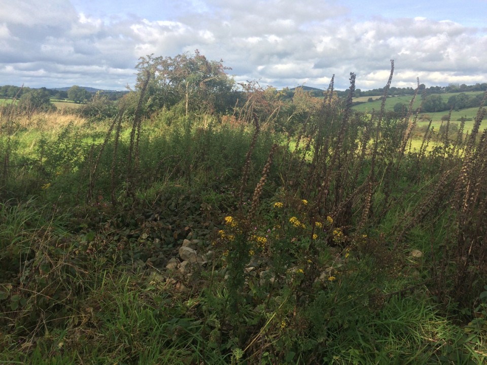
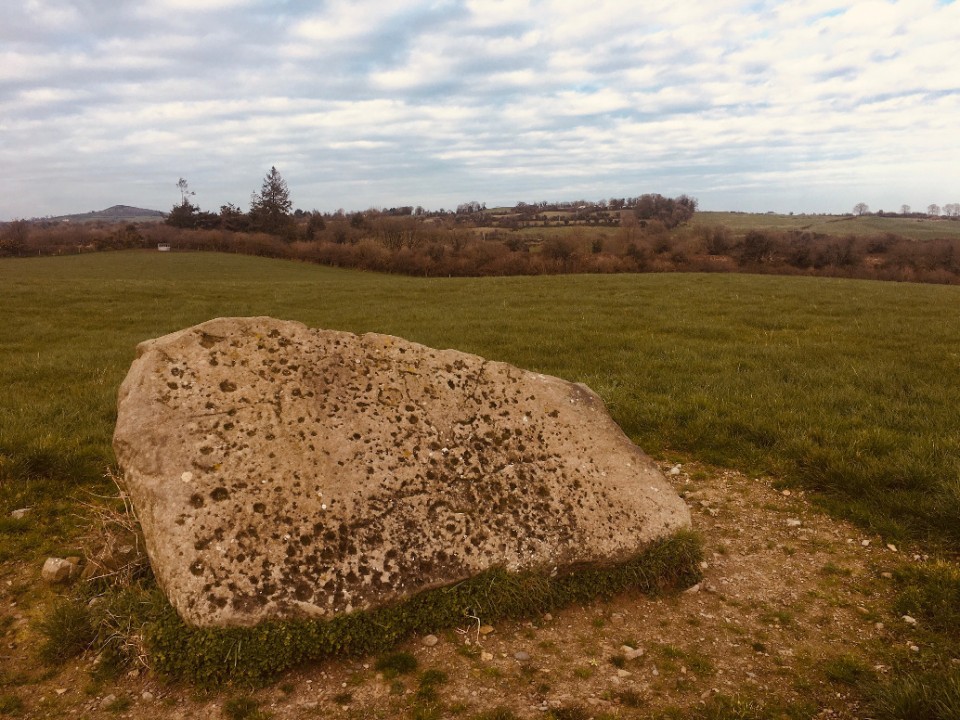
These two stones are located about 150 metres slightly east of south of the cairn in the same townland that I had visited earlier. No connection is made between them and the cairn in the Eogan notes on the SMR at archaeology.ie. These notes are taken from a paper that I haven't been able to access, so he may have mentioned a connection that I would say is fairly obvious. The southern side of the cairn is truncated and a wall has been built that delineates the two different fields that I suspect are owned by separate people. The cairn is somewhat preserved in the northern field. On the southern side it has been flattened to the surrounding ground level, ergo, these are two of the stones that were pulled from the cairn during this destruction. Anyhow, the broad flat face of the leaning stone is covered in what seem to be natural solution pits (they reminded me of the capstone at Rathkenny). A couple of these have rings carved around them and some of the pits may well have been enhanced. There are other markings on the stone, but in overcast light and without water, these were hard to make out. The stone leans at a 45 degree angle on another possible orthostat/kerbstone and as a result the carvings are now badly eroding. |
Posted by ryaner 9th March 2021ce |
Clonasillagh Cairn (Cairn(s)) — Fieldnotes |
|
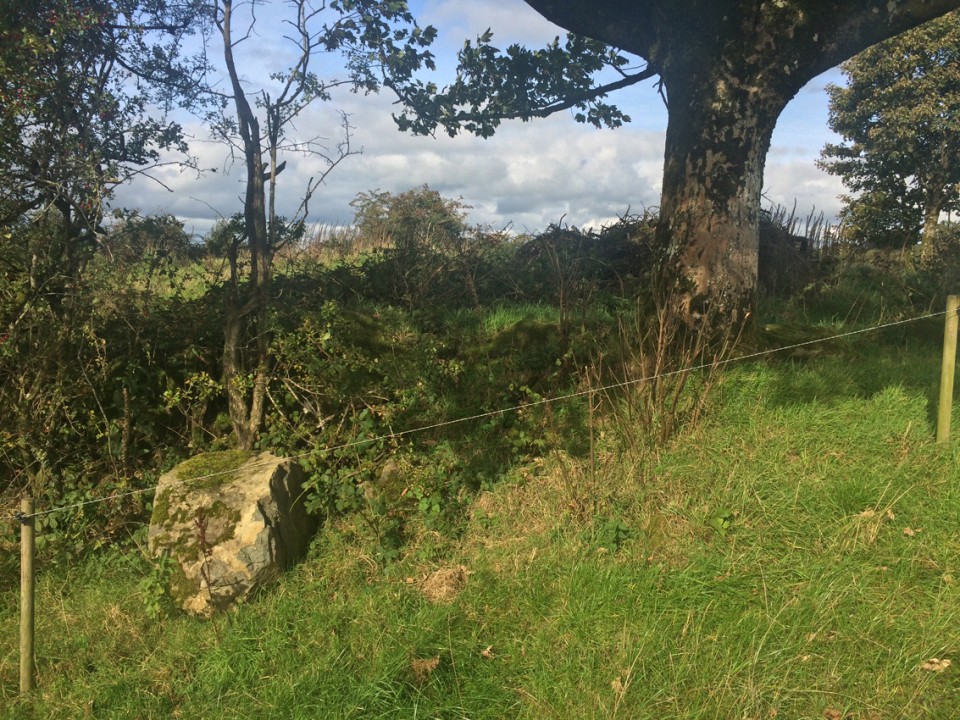
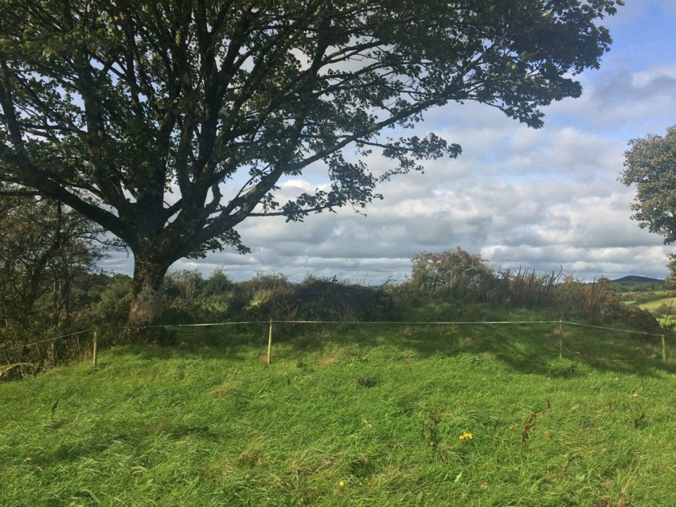
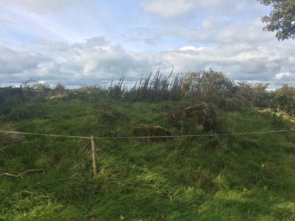
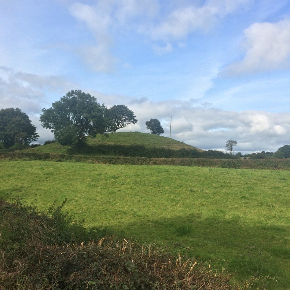
Having read Eogan's notes (see below) before setting out I was excited and intrigued at what I might encounter. After a long explanation about what we were after at the house at the bottom of the hill, we set out for the not too strenuous walk. There's an old railway cutting that needs to be surmounted and from the satellite pictures I was unsure of how to achieve this. Thankfully there is a gated gap that leads to the field in which the cairn lies. Early March is possibly the only time that you will get to see anything here. The cairn is a tangled mess of brambles, thorn trees, barbed wire and shrubbery. I couldn't see the opposing uprights that Eogan mentions. I did see some cairn rubble and what looked like two kerbstones, one in situ and one fallen outwards. From my prior research I wasn't really expecting much and I wasn't that disappointed, though there were the usual pangs of regret at the sad neglect. |
Posted by ryaner 9th March 2021ce |
Clonasillagh Decorated Stone (Cup and Ring Marks / Rock Art) — Images (click to view fullsize) |
|
Posted by ryaner 8th March 2021ce |
Clonasillagh Cairn (Cairn(s)) — Images |
|
Posted by ryaner 8th March 2021ce |
Clonasillagh Decorated Stone (Cup and Ring Marks / Rock Art) — Miscellaneous |
|
The SMR entry from archaeology.ie: Class: Decorated stone (present location) Townland: CLONASILLAGH Scheduled for inclusion in the next revision of the RMP: Yes Description: The remains of this monument have been described by Eogan (2000, 7-9) as follows: ‘What survives to-day is a large flat stone and a rounded boulder, possibly an orthostat and kerb-stone. These are not in their original position but were dumped there after destruction. There are some other stones in the area, but these are much smaller. The large decorated stone is at least probably one of the "large upright stones" referred to by Conwell. From local information, it appears that a monument stood very close to where the stones now are, but it is not possible to determine its precise location or the date of the removal, but this may have been about 1990. It was removed by bull-dozing; the two stones described in this paper were thrown aside and according to a local informant, a pit was dug into which other large stones were dumped. The area tends to slope to the south-east but adjoining ground to the north-west is higher. ??Stone A is a large flag 2.40m long. At one end it is 1.35m in maximum width; at the other it is about 1m. It is 0.40m in average width. The material is carboniferous sandstone with round calcareous concretions. Two parallel grooves near the top left-hand corner were caused by the teeth of the bulldozer bucket. Decoration occurs on the broad face that is visible and on one of the narrow sides. There is no decoration on the other three narrow sides. The other broad face is lying on the ground, but as it has not been possible to have it lifted, it is not known if it has decoration. The surface of the stone is weathered and this restricts information about the motifs, and in particular about the technique used in its application, but it may be assumed that pocking predominated. ?On the broad face cup-marks predominate, one hundred and forty one examples being present. These are natural hollows, often elliptical in shape, but there is a hint in some that human modification took place. The "cup-marks" vary in size from small examples 4cm in diameter to larger examples 10cm in diameter and 2cm in depth. Two other principal motifs are present - curvilinear and rectilinear. There are three curvilinear motifs. Two are similar, each of which consists of a hollow surrounded by a circle, the uppermost motif being the larger of these two circles. The lowermost circle is the largest overall example. This also has a central hollow which is surrounded by two concentric circles. A third member consists of an arc on one aide. A somewhat crescentic-shaped motif extends across the upper portion of the surface. This has inward-hooked ends. One end extends above and down one side of the central cup-and-circle motif. Another large motif consists of a straight line which extends up most of the surface. This appears to cut across the left side of the hooked motif and is, therefore, a later addition. Its overall chronological position cannot be determined, but its surface weathering is similar to that of the other motifs. Perhaps it is an overlay on a primary composition. However, prominent straight lines are not a feature of megalithic art. ?The decoration on the vertical side consists largely of a series of lines. These are usually parallel, either vertical or horizontal. Some constitute a motif in the shape of an inverted L, but others tend to form a gate-like pattern. Towards the broad end, the side slopes and in this small area there are twelve hollows, some of which Beam to have been modified. ??Stone B is a boulder that has minimum dimensions of 1.77m in length, 1.69m in width and 0.83m in depth. The material is also carboniferous sandstone. It has been damaged, probably at the time of bulldozing and flakes have been detached. There are ten hollows on one of the broader surfaces, mainly close to one of the edges. As is the case with Stone A, all seem to have been natural, but possibly some were modified as was suggested for Stone A.’ (Eogan 2000) |
Posted by ryaner 8th March 2021ce |
Clonasillagh Cairn (Cairn(s)) — Miscellaneous |
|
The SMR entry on archaeology.ie: Class: Cairn - unclassified Townland: CLONASILLAGH Scheduled for inclusion in the next revision of the RMP: Yes Description: This has been described by Eogan (2000, 9-11) as follows: ‘This site is situated on a knoll, from which visibility is not very extensive, the most prominent feature being Carrigasimon hill about 4km (slightly over 2 miles) to the north-east as the crow flies. Before clearance, in July 1999, the site was very overgrown with a variety of bushes. Hence, apart from the top of what appeared to be a couple of longish stones, it was almost impossible to distinguish the type of monument. After clearance, the presence of eight stones arranged in a circle was revealed. There is also a small stone near No. 6. Only three of these, Nos. 1, 2 and 6, were in their original positions, the other five having fallen. There is a gap between the stones, and without excavation it is not possible to say if the circle was complete, but if it was, then, taking the dimensions of the stones surviving in situ, about fifteen stones are missing. If so, the original number would have been about twenty three. An interesting feature of the circle is the presence of two large stones (Nos. 1 and 6). They are the most substantial in the monument, with that on the east being 1.70m in height. Its opposite number is 1.66m in height. Furthermore, they are opposite each other, giving an East-West orientation. These are much larger than the only other surviving upright stone. No. 2, which is 0.93m in height. The dual east-west orientation recalls the similar orientation at Knowth, Site 1 (Eogan 1986, Fig. 16). This monument is 15m in external diameter. No internal features are visible but there is a spread of cairn all over, and while its average depth cannot be determined. It appears to be about 40cm. The surface of the interior is generally flat, but in a couple of places there is a greater depth of cairn than in others. Outside the kerb, for most of its circumference, there is a spread of smallish stones. These might represent cairn slip, if a higher cairn existed, or it could represent cairn debris that accumulated if such a cairn was removed. Professor Phillips reported that "all the stones at this site are composed of massive unstratified coarse grained greywacke formed by submarine debris flows. The greywacke shows a prominent cleavage and there are some elliptical shaped calcareous concretions which have been flattened and stretched on the cleavage. The rock type is typical of the Silurian aged bedrock of nearby Carrigammon Hill. The surfaces of the stones are rough and have a growth of moss, but it has not been possible to detect art.’ (Eogan 2000) ??ME010-044----_01.pdf: Plan and section of the monument (surveyed May 1995). ??Compiled by: Paul Walsh ??Date of upload: 21 April 2015 References: 1. Eogan, G. 2000 A group of Megalithic monuments at Kingsmountain - Clonasillagh, Co. Meath, Ríocht na Mídhe, 11, 1016. |
Posted by ryaner 8th March 2021ce |