|
|

|
|
RathanganRath
|
||||||||||||||||||||||||
|
|
|
Images (click to view fullsize) |
|
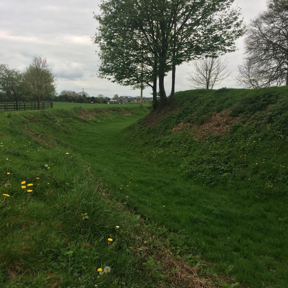
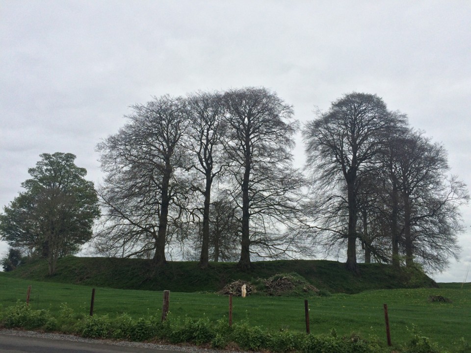
Photographs: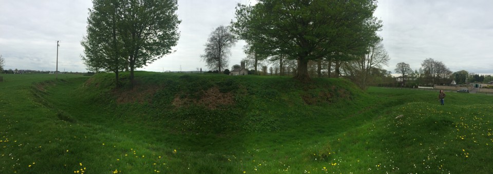
 Artistic / Interpretive:
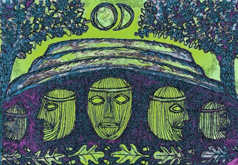
|
Miscellaneous |
|
|
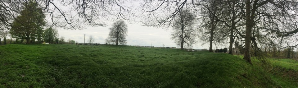
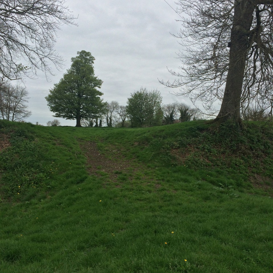
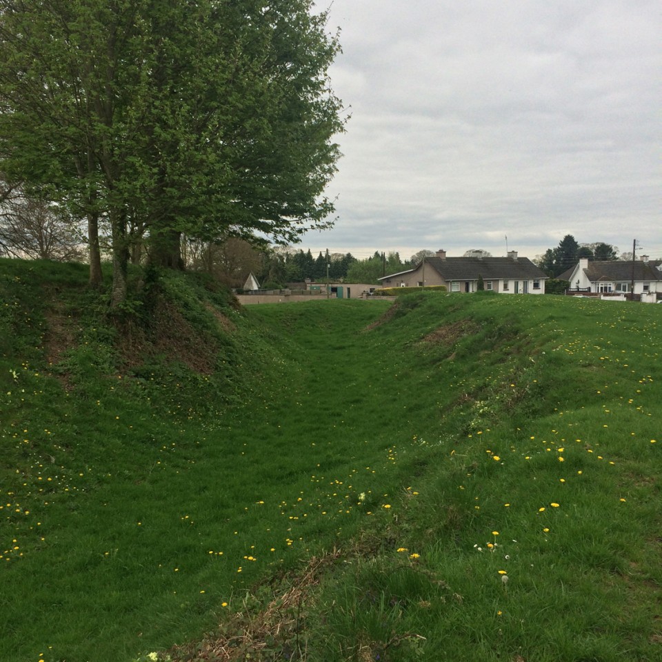
From archaeology.ie and worth quoting in full: Class: Ringfort - rath Townland: RATHANGAN (Rathangan ED) Scheduled for inclusion in the next revision of the RMP: Yes Description: The royal Fort of Rathangan was described in one of the earliest Irish poems as the burial place of the kings of the local clan. The poem records that the fort was located close to an oak woodland and that the ringfort belonged to the following local kings: ‘The fort over against the oak-wood, Once it was Bruidge’s, it was Cathal’s, It was Aed’s, it was Ailill’s, It was Conaing’s. it was Cuiline’s, And it was Maelduin’s. The fort remains after each in its turn And the kings asleep in the ground’ (Meyer 1913, 93). The modern name Rathangan is derived from a corruption of the Gaelic name of the bivallate royal ringfort Ráth Iomgháin meaning the fort of Iomgháin (Bradley et. al. 1986, 413). In the year 801 the Annals of the Four Masters recorded that ‘Flaithiusa, son of Cinaedh, lord of Ui-Failghe, was slain at Rath-Imghain’ (AFM, 413). The Annals of Ulster recorded the same killing as happening four years later in 805 (AU, 291-2). Fitzgerald (1906-8, 137, 158) suggests that in the late 12th century Rathangan was granted by Strongbow to Maurice FitzGerald, ancestor of the FitzGerald lords of Offaly. However Bradley (1986, 413) suggests that Rathangan may have been granted to Robert de Bermingham, as part of his cantred of Offaly (Orpen 1911-20, I, 381). By the middle of the 13th century the lands of Rathangan now forming the manor of Rathangan belonged to the FitzGeralds. In 1270 the custody of the manor of Rathangan [Rathingan] which formed part of the lands of the recently deceased Sir Maurice FitzGerald were granted to Thomas de Clare, brother of the earl of Gloucester, through his marriage with Juliana FitzMaurice, daughter of Sir Maurice FitzGerald (Cal. doc. Ire, 141). In 1308 Gerald, heir to Maurice FitzGerald, held his court at the manor of Rathangan (Cal. justic. rolls, Ire. Edw. II, 82). Rathangan was located on the borders of the Ui Concobhair/O’Connor territory of Ui Failghe. In 1331 on the death Richard FitzThomas, earl of Kildare the burgage rent of Rathangan was valued at £6 3s. 2d., indicating that there were 120 burgages (MacNiocaill 1964, 102; Bradley et. al. 1986, 414). This bivallate royal ringfort is located at the W end of the village on high ground with good views in all directions. The 19th century C of I church and graveyard located 50m to the E probably stands on the site of the medieval church (KD017-011003-) and graveyard (KD017-011007-). Ringfort described in the Ordnance Survey letters in 1837 as following; ‘this mound is at present planted, and is about one hundred and eighty [54.8m] in diameter, and measures from its base to its summit, slantwise, about forty two feet [12.8m], which would probably make about twenty eight feet [8.5m] in perpendicular height. It is encircled with a large ditch which is about seven hundred and thirty eight feet [225m] in circumference; and a fosse, which is partly destroyed, mostly on the south and east side’ (O’Flanagan 1927, 50). Ringfort described by Bradley (1986 et. al., 418) as ‘a very large raised platform surrounded by a deep ditch and counter-scarp bank. The interior diameter is 60m E-W by 58m N-S. There is an internal bank, 2m wide, with a maximum height of 2m on the NE. The bank is eroded on the N and SW sides. There are a few raised areas in the centre but no coherent pattern can be discerned. It is surrounded by a ditch 6.5m in width and 4-5m in depth below the top of the internal bank. There are traces of a counter-scarp bank particularly on the E and S sides. There is a causeway over the ditch on the E’. Sweetman (1999, 13-14) suggests that the Anglo-Normans, re-fortified the ringfort in the late 12th century, which 'was altered to make it into a ringwork castle'. Present remains consist of a fairly well-preserved, roughly circular, raised area (int. diam. 58m) enclosed by a broad, inner, earthen bank (Wth 9m; int H 1.7m; ext H 5m) best preserved along the N and E, denuded along the W and reduced to a scarp at SW, and by a U-shaped fosse (Wth 4m; D 2m). An entrance gap (Wth 3m) in the bank has a corresponding causeway (Wth 5.2m) across the fosse at SE. Mature oaks grow on the bank E-S-W, and both the outer faces of the bank and fosse are overgrown with briar and nettle. Two ESB poles stand on the outer face of the fosse, at N and SE. In 1955 'a slight outer bank' was noted (SMR file) today this outer bank which has been mainly levelled and is visible as a low rise of ground that is only visible when the vegetation cover is low such as in the winter months. (Otway-Ruthven 1980, 10; Bradley et al 1986 vol. 4, 418; Herity 2002, 133 (130); Stout 1997, 115-16) Compiled by: Gearóid Conroy Revised by: Caimin O'Brien Date of revised upload: 4 March 2016 This monument is subject to a preservation order made under the National Monuments Acts 1930 to 2014 (PO no. 10/1970). References: 1. AFM - Annals of the kingdom of Ireland by the Four Masters from the earliest period to the year 1616, ed. and trans. John O'Donovan (7 vols., Dublin, 1851; reprint New York, 1966) 2. AU - Annála Uladh, The Annals of Ulster; otherwise Annála Senait, Annals of Senat; a chronicle of Irish affairs, 431-1131, 1155-1541, ed. W.M. Hennessy and B. MacCarthy, (4 vols., Dublin 1887-1901) 3. Bradley, J., Halpin, A., and King, H.A. 1986 Urban Archaeological Survey - County Kildare (4 vols.). Unpublished report commissioned by the Office of Public Works, Dublin. 4. Cal. doc. Ire. - Calendar of documents relating to Ireland 1171-1307, ed. H.S. Sweetman (5 vols., London, 1875-86). 5. Cal. justic. rolls, Ire. Edw. II - Calendar of the justiciary rolls or proceedings in the court of the justiciar of Ireland, 1 to 7 years of Edward II. Revd. by Margaret C. Griffith (Dublin, 1956) 6. Herity, M. (ed.) 2002 Ordnance Survey Letters Kildare. Dublin. Four Masters Press. 7. Mac Niocaill, G. 1964 The red book of the earls of Kildare. Dublin. Irish Manuscripts Commission. 8. Meyer, K. 1913 Ancient Irish Poetry. 9. O'Flanagan, Rev. M. (Compiler) 1927 Letters containing information relative to the antiquities of the county of Kildare collected during the progress of the Ordnance Survey in 1838. Bray. 10. Orpen, G.H. 1911-20 Ireland under the Normans (1169-1216), 5 Vols. Oxford. Clarendon. 11. Otway-Ruthven, A.J. 1968 A history of medieval Ireland. London. Ernest Benn. 12. Stout, M. 1997 The Irish ringfort. Dublin. Four Courts Press. 13. Sweetman, D. 1999 The medieval castles of Ireland. Cork. The Collins Press. |
 Posted by ryaner
21st April 2017ce Edited 21st April 2017ce |