The Modern Antiquarian
Log in
|
Register
Home
Latest Posts
Forums
Maps
Help
Browse Sites
News
Blog
Contributors
The Books
Select
-
Belgium
Denmark
Eire
France
Germany
Greece
Italy
The Netherlands
Norway
Portugal
Republic of Malta
Spain
Sweden
Switzerland
United Kingdom
England
Southern England
Hampshire
Oram's Arbour
Hillfort
Oram's Arbour (Hillfort) on The Modern Antiquarian, the UK & Ireland's most popular megalithic community website. 2 images, plus information on many more ancient sites nearby and across the UK & Ireland.
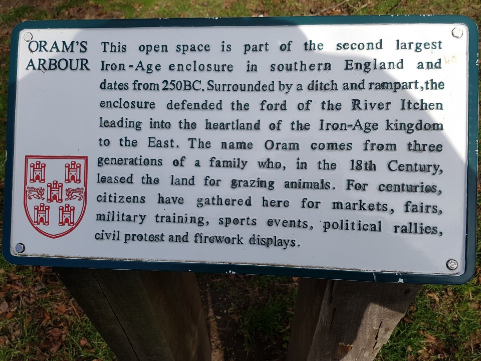
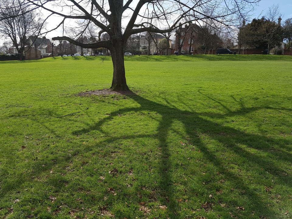
Image © Graham Orriss
OS Ref (GB):
Latitude:
51° 3' 53.47" N
Longitude:
1° 19' 21.14" W
Added by
goffik
Images (2)
0 discussions
Start a topic
Show |
Hide
Web searches for Oram's Arbour
Flickr
Google
Google Images
Bing
Stone Pages
Wikipedia
Show map
(inline Google Map)
- Sites within 20 km -
-
St Catherine's Hill (2.41km SE) (22 posts)
Oliver's Battery (2.52km SW) (7 posts)
Magdalen Hill Down Barrows (2.55km E) (11 posts)
Flowerdown Barrows (2.71km WNW) (15 posts)
Texas Barrows (3.37km SW) (5 posts)
St Mary's Church, Twyford (4.72km SSE) (5 posts)
Telegraph Hill Barrow (4.98km E) (7 posts)
Twyford Pumping Station Barrows (5.22km SE) (3 posts)
Littleton House Bowl Barrow (5.25km NW) (2 posts)
Cheesefoot Head Barrows (5.39km E) (4 posts)
Love Lane (5.4km SE) (3 posts)
Wallers Ash Barrow (5.8km N) (2 posts)
South Wonston South-west Long Barrow (5.8km NW) (5 posts)
West Wood (6.16km WSW) (7 posts)
Merdon Castle (6.27km WSW) (2 posts)
South Wonston East Long Barrow (6.31km N) (2 posts)
South Wonston Long Barrow (6.31km NNW) (6 posts)
South Wonston North Long Barrow (6.93km NNW) (3 posts)
Crawley Clump East Barrows (7.19km NW) (3 posts)
Crawley Clump West Barrows (7.35km NW) (4 posts)
Farley Mount Enclosure (7.37km WSW) (9 posts)
Withering Corner Barrows. (7.97km WSW) (6 posts)
Owslebury (8km ESE) (6 posts)
Longwood House Long Barrow (8km ESE) (6 posts)
Micheldever Woods (8.69km NE) (13 posts)
Gander Down (8.71km E) (2 posts)
Barton Stacey Barrows (9.22km NW) (1 post)
Itchen Stoke Down Barrows (9.24km ENE) (2 posts)
Moody's Down (9.74km NW) (2 posts)
Dirty Mount (9.89km WSW) (4 posts)
Chilbolton Round Barrows (9.96km WNW) (1 post)
Chilbolton Down Long Barrow (10.21km WNW) (1 post)
Moody’s Down Farm (10.22km NW) (2 posts)
New Farm (10.22km WNW) (1 post)
Heardulfes Hlaewe (10.3km WNW) (1 post)
Kitson’s Clumps (10.31km N) (1 post)
Little Somborne Hillfort (10.33km WNW) (1 post)
Leckford Barrows (10.36km WNW) (1 post)
Norsebury Ring (10.44km N) (5 posts)
Cheriton Church Mound (10.69km E) (4 posts)
Newton Down Farm (10.69km NW) (2 posts)
Woolbury (10.84km W) (11 posts)
The Millbarrows (11.06km E) (5 posts)
Stockbridge Down (11.56km W) (2 posts)
Cheriton Long Barrow (11.78km E) (7 posts)
Lamborough (11.79km E) (2 posts)
Hinton Ampner Park (12.37km E) (1 post)
Oliver's Battery (12.64km ENE) (3 posts)
Kilmeston (12.75km E) (3 posts)
Cranbourne Wood Long Barrow (12.77km N) (1 post)
Tidbury Ring (13.16km NNW) (5 posts)
Andyke (13.69km NW) (4 posts)
Chilworth Ring (14.18km SSW) (2 posts)
Toothill Fort (14.56km SW) (4 posts)
Popham Beacons (14.97km NNE) (10 posts)
Moorgreen House (14.97km S) (1 post)
Monarch Way (14.97km S) (1 post)
Three Barrows (Laverstoke) (14.99km N) (1 post)
Freefolk Wood Barrows (15.18km N) (1 post)
Brockwood Park (15.36km E) (1 post)
Waters Down Farm (15.94km W) (1 post)
Danebury Round Barrows (16.08km W) (1 post)
Danebury Long Barrows (16.97km W) (7 posts)
Danebury (16.97km W) (43 posts)
Lockerley Camp (17.45km WSW) (1 post)
Dunwood Camp (17.48km WSW) (2 posts)
Danebury North-East long barrow (17.5km W) (1 post)
West Meon (17.68km E) (1 post)
Abra Barrow (17.73km N) (4 posts)
Netley Hill (17.77km S) (1 post)
The Turret (18.54km W) (2 posts)
Whiteshoot Hill (18.57km W) (2 posts)
Bury Hill (18.84km WNW) (20 posts)
Testwood Lakes (19km SW) (1 post)
Old Winchester Hill (19km E) (24 posts)
The Jumps (19.14km E) (1 post)
Balksbury (19.18km WNW) (4 posts)
Stock's Farm Long Barrow (19.25km E) (3 posts)
- Add -
-
Add news
Add an image
Add fieldnotes
Add folklore
Add miscellaneous
Add a link
-
Add a site
Add a nearby facility
Add an alternative name/spelling
Images
(click to view fullsize)
Add an image
 Image © Graham Orriss