|
|

|
|
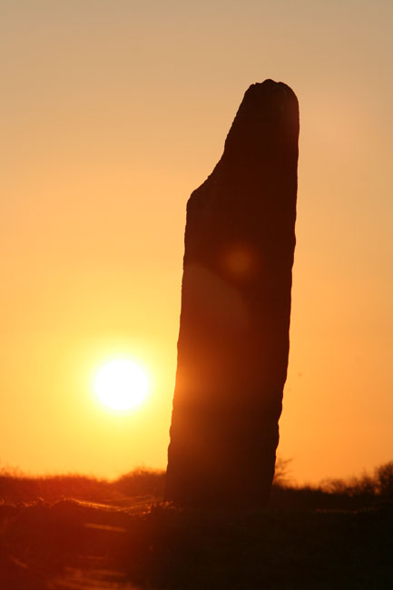
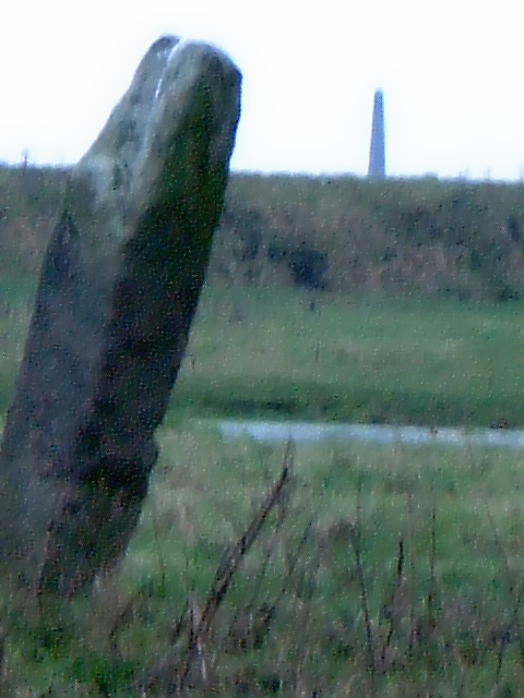
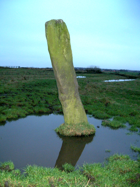
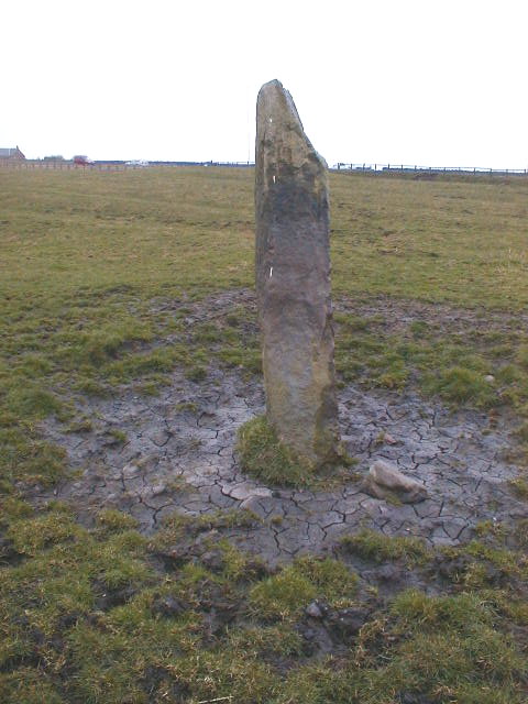
Old HartleyStanding Stone / Menhir
|
|
|
|
Images (click to view fullsize) |
|
Photographs: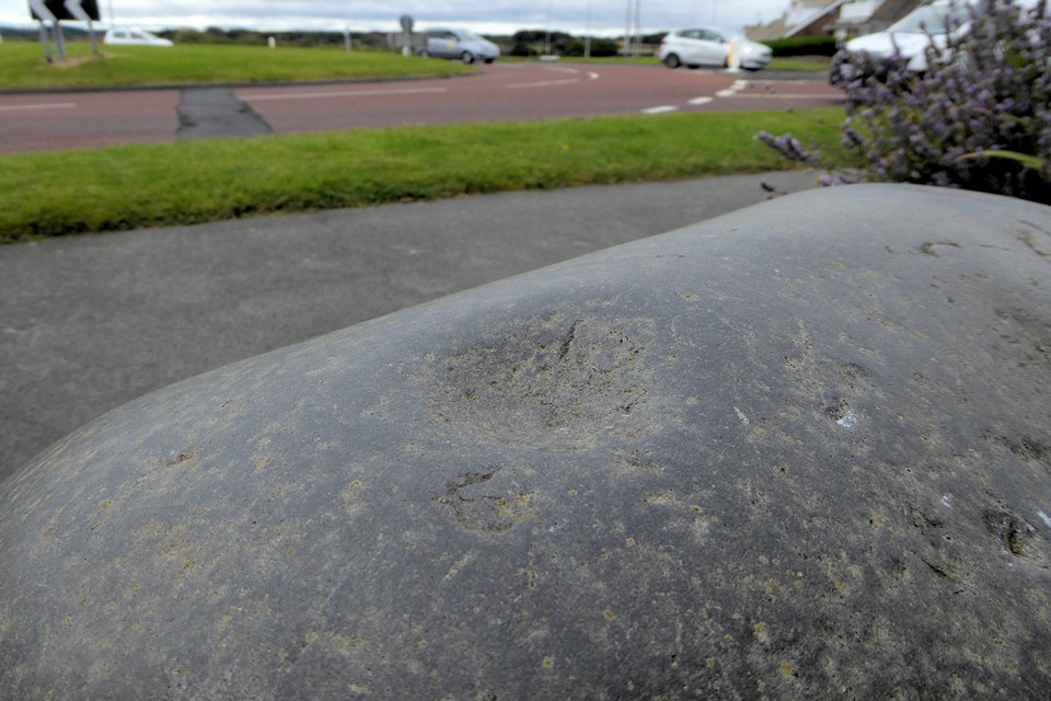
 Artistic / Interpretive:
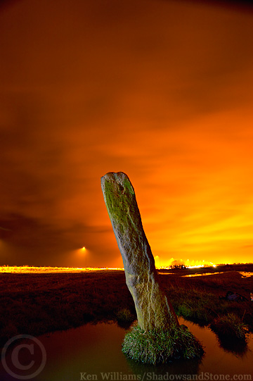
|
Fieldnotes |
|
|
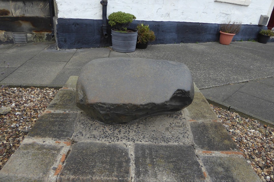
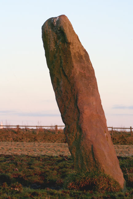
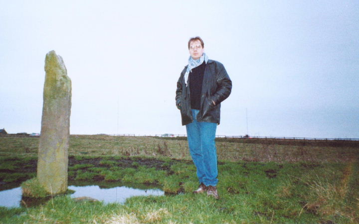
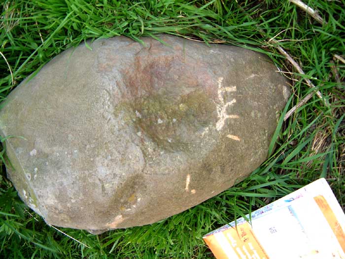
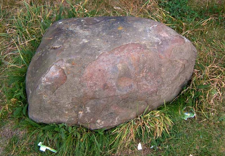
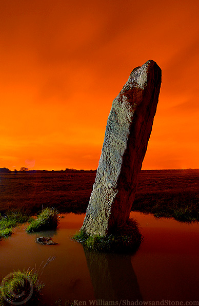
20th July 2005 Still not fallen over. Closer examination of the bluestone outside the pub is starting to convince me that it might be an artificial cup mark, but the stone is seriously igneous, so I'm not 100% convinced. 6th May 2004 May Day inspection of this thing showed it hasn't fallen over yet. This time I think I can state that despite the lack of professionally countenanced provenance, it's not a medeival boundary marker. It may have been used as such, and is still only a few yards away from the county border, but close inspection of the marks leads me to think that it has been pounded with stones, not with metal tools. It also has a shoulder, and is not regular all over. I suspect that these marks, and the rectangular cross section, may have led it to be discounted as a megalith by any surveying archaeologists. There is another stone very similar to the bluestone (see the nearby pub), at the SE edge of the field. Like the bluestone,his igneous looking stone also shows signs of extreme heating, and has a shallow, 6" wide depression pecked into it. Curious, but not really proof of anything at all I guess 18th Sept 2003 The upright stone is clearly visible from the Blyth-Whitley Bay road. It's about 2m high, easiest way into the field is to park in the Deleval Arms and use the gate in the NE corner. Disabled Access poor as the gate is wired shut and ground is rough and uneven. The blue stones are in front of the Pub and in the carpark behind it. Some general waffle about the surrounding landscape:- Anyone interested in the neuro-electromagnetic aspects of prehistoric sites should out the area, as this stone is rather close to a heavy-duty faultline which emerges into the sea at nearby Collywell bay, causing lines of lava intrusions that have warped the rocks into strange formations. (This bay may once have been held special due ti the crystals found in the cliff, digging of which has now resulted in the bay being visually marred by the protective concrete). The nearby natural harbour would have long been recognised as a place of much worth to sea-faring folk, and there is a possible causewayed enclosure a mile or so to the north of the Hartley stone, and another closer circular(ish) earthwork of ancient, but unsecified purpose. The ridge upon which the former enclosure sits also has the particular silhouette view of the Simonside hills that is often associated with prehistoric sites in this end of Northumberland. Add to this the island with St. Mary's lighthouse, and the local landscape, though much ravaged by millenia of constant human activity, is still capabe of betraying the occasional hint of ancient activity. |
 Posted by Hob
18th September 2003ce Edited 13th October 2005ce |
Folklore |
|
|
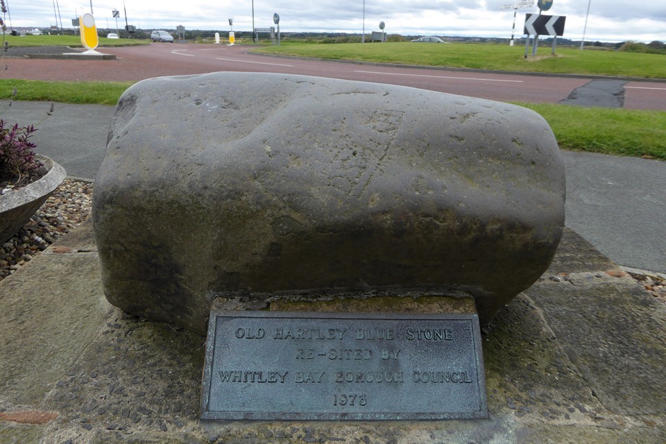
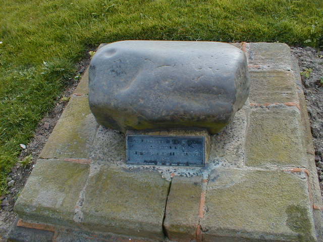
According to the Pub Barstaff, the bluestone directly in front of the Deleval Arms is not the original, but was placed as a decoy to prevent drunken locals damaging the original, which has been dumped in the beer garden at the back of the pub. It's also said that the correct spelling is 'Blewstone' and that this refers to the stone's original status as the 'ancient saxon oath stone' that was previously in the centre of the now demolished village of Hartley. The immediate area is dripping with macabre folklore regarding the Deleval family, who had a reputation for madness, wild parties and witch-burning. According to 'County Folklore Vol IV, Northumberland', 1904, by MC Balfour, this stone was known as the witches obelisk. It had a variation of an old common theme which said that if you were to run round it seven times without stopping, 'The Witch' would appear. Here's the text on display in the Deleval Arms Hotel: "The Blue whinstone at the Old Hartley, near the entrance to the Deleval Arms Hotel, once marked the centre of the village of Old Hartley. A number of these large stones can be seen at various places on the Northumberland coast. It is generally supposed that they rolled down during the ice age when the ice moved from west to east at the time of the great thaw. In the early English and Saxon periods, they were called 'Moot Stones' and were used as a meeting place by the 'Wittan', a council of Village elders who gathered to formulate the laws and dispense justice. During Norman times these stones were used as markers for castles and boundaries. "Ye large Blew Stone marked ye site of Warkworth Castle" and at Mokseaton, "Ye Boulder Stone was a large "Blew Stone" near ye burn". The Old Hartley Blue Stone marked the centre of the village and stood near the Blacksmith's shop, it was here that the villagers would meet before setting out on a journey. At the time of the black death in 1348 it was thought that if one touched the stone they would be immune from the plague. Over the years the stone became a symbol of good fortune and it was said to become a citizen of Old Hartley you had first to kiss the Blue Stone. The Story goes that William Carr, the Hartley Samson, who was born at the Hartley Old Engine, and who was in his prime was the strongest man in all England, used to demonstrate his strength by lifting the stone and carrying it under his arm. When the old village was demolished in 1940, the stone was buried in the path leading from the Blacksmith's shop to the PM chapel and when the new road was planned, Mr Wesley Dickinson removed the stone for safe keeping. When the roadworks were completed in 1973, the Whitley Bay Borough Council replaced the stone as near as possible to it's original position." According to C.T. Trechmann in 1913, the area immediately to the east of the stone yielded evidence of prehistoric flintworking. Whilst this proves nowt about the age of the stone, the concentration of flints opposite St Mary's island was in direct contrast with the paucity of similar evidence between this area and the mouth of the Tyne. 'Notes on Neolithic Chipping Sites in Northumberland and Durham' (Transactions Natural History Society of Northumberland, Durham and Newcastle, 2, IV pt. 1, p. 81) |
Posted by Hob 18th September 2003ce Edited 8th September 2006ce |