The Modern Antiquarian
Log in
|
Register
Home
Latest Posts
Forums
Maps
Help
Browse Sites
News
Blog
Contributors
The Books
Select
-
Belgium
Denmark
Eire
France
Germany
Greece
Italy
The Netherlands
Norway
Portugal
Republic of Malta
Spain
Sweden
Switzerland
United Kingdom
Northern Ireland
County Armagh
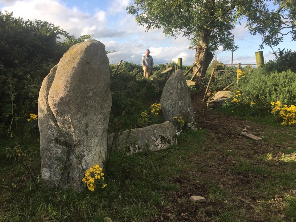
Eshwary
Court Tomb
Eshwary (Court Tomb) on The Modern Antiquarian, the UK & Ireland's most popular megalithic community website. 3 images, plus information on many more ancient sites nearby and across the UK & Ireland.
Image © ryaner
OS Ref (GB):
J027286 /
Sheet: 29
Latitude:
54° 11' 45.44" N
Longitude:
6° 25' 34.53" W
Added by
FourWinds
Images (3)
0 discussions
Start a topic
Show |
Hide
Web searches for Eshwary
Flickr
Google
Google Images
Megalithomania
Bing
Stone Pages
Streetmap.co.uk
Wikipedia
Show map
(inline Google Map)
- Sites within 20 km -
-
Aghmakane (3.37km S) (6 posts)
Cross (3.94km ESE) (8 posts)
Belleek (4.15km WSW) (5 posts)
Outleckan (4.92km W) (5 posts)
The Ballard Longstone (5.31km S) (7 posts)
Drummiller (5.32km ENE) (2 posts)
Ballymacdermot (6.03km ESE) (27 posts)
Clonlum (7.38km SSE) (3 posts)
Slieve Gullion - North Cairn (7.41km S) (10 posts)
Ballykeel (7.5km SSW) (24 posts)
Latbirget (7.71km SSW) (5 posts)
The Dorsey Entrenchment (8.17km SW) (7 posts)
Clonlum South (8.21km SSE) (9 posts)
Callaigh Berra's House (8.29km S) (39 posts)
Callaigh Berra's Lough (8.6km S) (6 posts)
Crobane (9.39km E) (3 posts)
Saval More Graveyard Stones (9.66km ENE) (4 posts)
Saval More (Field Stone) (9.81km ENE) (1 post)
Clontygora - Court Tomb (11.73km ESE) (38 posts)
Tullyvallan (Tipping) West (11.87km WSW) (5 posts)
Burren (12.36km E) (6 posts)
Tullynavall (12.99km SW) (4 posts)
Tamnaharry (13.33km E) (0 posts)
Mayo 1 (13.4km E) (4 posts)
Mayo 2 (13.96km E) (5 posts)
Kilnasaggart (14.08km SSE) (0 posts)
Warrenpoint Standing Stone (14.41km ESE) (4 posts)
The Three Sisters (14.59km NE) (0 posts)
Ravensdale Park (14.65km SE) (10 posts)
Tamary Cairns (14.67km ENE) (0 posts)
Clermont Cairn (14.69km SE) (0 posts)
Barnmeen (15.07km ENE) (4 posts)
Drumnahare (15.32km NE) (3 posts)
Carnadranna (15.52km E) (2 posts)
Aghnaskeagh (15.53km SE) (2 posts)
Aghnaskeagh Chambered Cairn (15.62km SE) (3 posts)
Aughnagurgan (15.64km W) (0 posts)
Aughnagurgan (15.66km W) (9 posts)
Aughnagurgan (15.72km W) (4 posts)
Vicars Carn (15.86km WNW) (6 posts)
Mullyash (15.97km WSW) (9 posts)
Faughart (16.04km SSE) (6 posts)
Drumnasillagh (16.22km SE) (7 posts)
Annaghmare (16.24km SW) (27 posts)
Murphy's Fort, Mullaghmore (16.49km E) (1 post)
Mullaghmore (16.59km E) (0 posts)
Lurgankeel (16.88km S) (4 posts)
Carnawaddy (16.94km SE) (5 posts)
Lurgankeel (16.97km S) (0 posts)
The Meadow (16.99km SE) (0 posts)
Corrakit (17km ESE) (0 posts)
Coolnacran (17.3km NNE) (4 posts)
Balriggan (17.35km SSE) (1 post)
Knockiveagh (17.97km ENE) (6 posts)
Rostrevor Standing Stone (18.34km E) (6 posts)
Proleek (18.43km SE) (31 posts)
Proleek (18.43km SE) (12 posts)
Killin (18.45km S) (0 posts)
Ballymakellet Standing Stone (18.61km SE) (1 post)
Carn Beg (18.62km SSE) (5 posts)
Ballymakellet (18.7km SE) (3 posts)
- Facilities within 20 km -
-
Lake Vyrnwy Tourist In... (Tourist Information: 9 km S)
- Add -
-
Add news
Add an image
Add fieldnotes
Add folklore
Add miscellaneous
Add a link
-
Add a site
Add a nearby facility
Add an alternative name/spelling
Images
(click to view fullsize)
Add an image
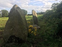 Image © ryaner