The Modern Antiquarian
Log in
|
Register
Home
Latest Posts
Forums
Maps
Help
Browse Sites
News
Blog
Contributors
The Books
Select
-
Belgium
Denmark
Eire
France
Germany
Greece
Italy
The Netherlands
Norway
Portugal
Republic of Malta
Spain
Sweden
Switzerland
United Kingdom
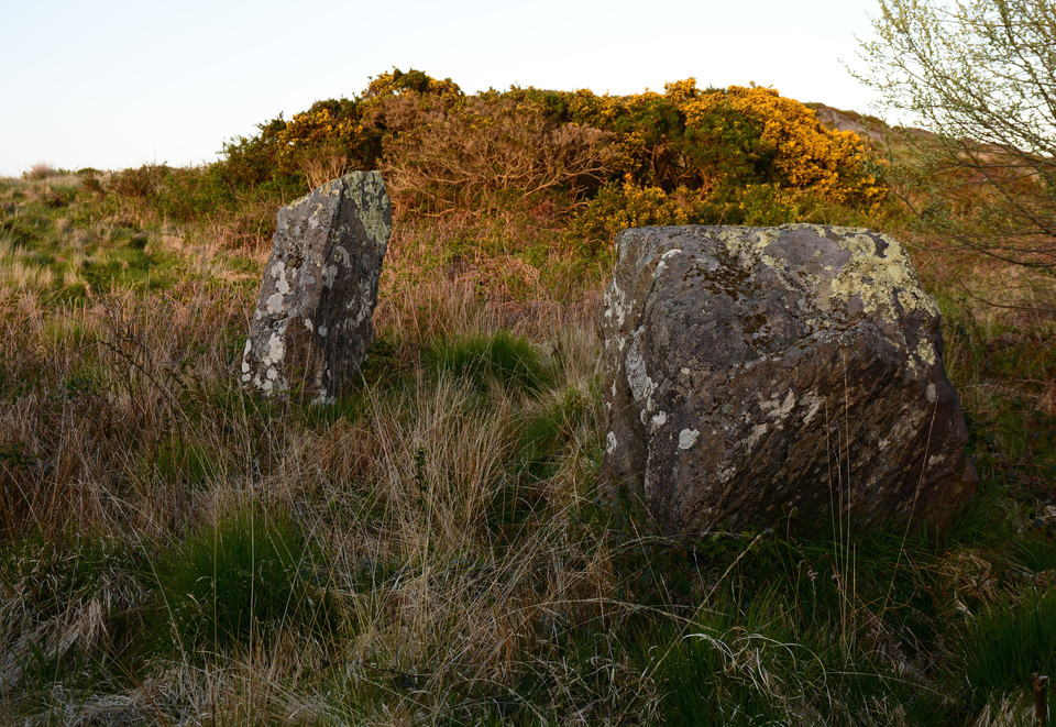
County Cork
Behagullane
Stone Row / Alignment
Behagullane (Stone Row / Alignment) on The Modern Antiquarian, the UK & Ireland's most popular megalithic community website. 1 image, plus information on many more ancient sites nearby and across the UK & Ireland.
Image © Charles Coughlan
OS Ref (IE):
Latitude:
51° 45' 28.76" N
Longitude:
9° 2' 54.17" W
Added by
bogman
Images (1)
0 discussions
Start a topic
Show |
Hide
Web searches for Behagullane
Flickr
Google
Google Images
Bing
Stone Pages
Wikipedia
Show map
(inline Google Map)
- Sites within 20 km -
-
Toom (1.64km ESE) (4 posts)
Kinneigh (3.41km E) (5 posts)
Kinneigh (3.54km ENE) (4 posts)
Nedinagh West (4.78km SSW) (3 posts)
Moneygaff West (5.03km NE) (5 posts)
Ballyhalwick (5.17km SSW) (3 posts)
Inchincurka (5.25km WNW) (15 posts)
Knockanereagh (5.72km N) (8 posts)
Dunmanway North (5.97km SW) (5 posts)
Derrynasafagh (6.38km WSW) (3 posts)
Lackanashinagh (7.02km NE) (0 posts)
Knockaunnagorp (7.09km N) (0 posts)
Coolaclevane (7.11km N) (3 posts)
Coolaclevane (7.3km N) (3 posts)
Reanacaheragh (7.31km NE) (0 posts)
Farrannahineeny (7.38km W) (16 posts)
Inchireagh (8.59km WSW) (11 posts)
Derrynacaheragh (8.75km WSW) (2 posts)
Milleennagun (9.24km SSE) (12 posts)
Milleennagun (9.27km SSE) (3 posts)
Caherkirky (9.34km SE) (11 posts)
Coolmountain (9.34km W) (7 posts)
Knockane (9.41km NE) (8 posts)
Lettergorman (North) (9.42km S) (25 posts)
Laravoolta 2 (9.55km ENE) (3 posts)
Laravoolta 1 (9.63km ENE) (2 posts)
Barnadivane (9.79km NE) (0 posts)
Rossnakilla (10.19km NNE) (9 posts)
Rossnakilla (10.19km NNE) (0 posts)
Garranereagh (10.25km ENE) (4 posts)
Killaneer (10.59km ENE) (3 posts)
Knockawaddra W (10.71km S) (17 posts)
Knockawaddra E (10.74km S) (15 posts)
Hornhill (10.75km ENE) (8 posts)
Knocks (East) (10.82km ESE) (7 posts)
Hornhill (10.88km ENE) (5 posts)
Coolnaconarty (11.18km SE) (9 posts)
Farnanes (11.19km WSW) (9 posts)
Knocknaneirk SW (11.19km ENE) (17 posts)
Knocks N (11.26km SSE) (20 posts)
Bengour West (11.36km ENE) (6 posts)
Knocknaneirk NE (11.61km NE) (13 posts)
Bengour East (11.62km ENE) (6 posts)
Knocks (11.67km SSE) (2 posts)
Inchinattin (11.87km SSE) (2 posts)
Clearagh (12.13km NE) (2 posts)
Knocks (12.16km SSE) (13 posts)
Glanbrack (12.18km S) (15 posts)
Cullenagh (12.27km WSW) (9 posts)
Maulatanvally (12.29km S) (8 posts)
Maulatanavally (12.52km S) (26 posts)
Garryglass (12.63km SSW) (3 posts)
Knocks S (12.63km SSE) (18 posts)
Garrygalss (12.63km SSW) (0 posts)
Teergay (12.79km N) (8 posts)
Carrigagrenane NE (13.08km S) (7 posts)
Knockatlowig (13.11km SE) (10 posts)
Turnaspidogy (13.17km WNW) (8 posts)
Cullenagh (13.36km WSW) (11 posts)
Carrigagrenane SW (13.63km S) (9 posts)
Sarue (13.8km SSE) (7 posts)
Clodagh Row (13.84km WSW) (12 posts)
Letter (site E) (13.91km ESE) (11 posts)
Clodagh (14.11km WSW) (19 posts)
Ahaghilla (14.28km SE) (13 posts)
Goulacullin (14.46km WSW) (4 posts)
Cashelisky (14.5km ESE) (9 posts)
Reavouler (14.99km SSW) (14 posts)
Kylefinchin 2 (15km NNW) (5 posts)
Cousane (15.06km WSW) (4 posts)
Currahy (15.08km WNW) (4 posts)
Kylefinchin (15.12km NNW) (1 post)
Currabeha (South) (15.38km ENE) (7 posts)
Ballyvoge 1 (15.38km NNW) (6 posts)
Dooneens (15.5km W) (4 posts)
Shronacarton (15.58km SW) (6 posts)
Ballyvackey (15.6km SE) (30 posts)
Laughtneill (15.64km ENE) (9 posts)
Reanascreena (15.7km S) (46 posts)
Gortyleahy (15.84km NNE) (4 posts)
Tullig Stone (16.25km S) (3 posts)
Cousane (16.26km WSW) (10 posts)
Currabeha (North) (16.35km ENE) (7 posts)
Dooneens (16.6km W) (9 posts)
Garranes North (16.65km WSW) (6 posts)
Cools (16.65km NNW) (3 posts)
Freahanes (16.69km SSE) (7 posts)
Inchinlinane (16.8km NNW) (5 posts)
Bellmount Upper SW (16.81km ENE) (9 posts)
Templebryan (16.88km ESE) (0 posts)
Carrigaphooca (16.89km N) (7 posts)
Lack More (16.91km NW) (9 posts)
Bellmount Upper NE (17.07km ENE) (9 posts)
Maughanaclea NE (17.16km WSW) (9 posts)
Templebryan (17.16km ESE) (23 posts)
Killinga (17.34km SSW) (6 posts)
Western Pap (17.45km W) (9 posts)
Derryfineen (17.58km NW) (5 posts)
Rosnascalp (17.6km NE) (4 posts)
Reananarree (17.63km NW) (3 posts)
Derryfineen (17.67km NW) (6 posts)
Bealick (17.7km NNE) (3 posts)
Keamcorravooly (17.7km WNW) (11 posts)
Reananerree (17.76km NW) (11 posts)
Keamcorravooly (17.76km WNW) (4 posts)
Barnagowlane West (17.9km WSW) (9 posts)
Baurnahulla (18.07km SW) (3 posts)
Ballyroe (18.12km SSW) (8 posts)
Cappaboy Beg (18.21km W) (2 posts)
Cappaboy Beg (18.21km W) (3 posts)
Cappaboy Beg SE (18.23km W) (7 posts)
Derryduff (18.28km SSE) (4 posts)
Lissacresig 2 (18.29km NNW) (5 posts)
Lissacresig 3 (18.29km NNW) (4 posts)
Lissacresig 1 (18.29km NNW) (4 posts)
Gorteennakilla (18.3km WNW) (6 posts)
Cappaboy Beg (18.39km W) (2 posts)
Cappaboy Beg (18.49km W) (4 posts)
Tinneel (18.56km SSE) (8 posts)
Lissacresig (18.61km NNW) (3 posts)
Maughanaclea Centre (18.65km WSW) (7 posts)
Gortanimill (18.67km NW) (16 posts)
Gortafludig (18.68km W) (0 posts)
An Screathan Mór (18.79km WNW) (3 posts)
Gurteenaduige (18.8km SSW) (8 posts)
Gortnacowly (18.9km WSW) (15 posts)
Bealick (19.16km NNE) (0 posts)
Cahermuckee (19.35km W) (5 posts)
Kilboultragh (19.51km N) (1 post)
Cappaboy Beg NW (19.99km W) (6 posts)
- Add -
-
Add news
Add an image
Add fieldnotes
Add folklore
Add miscellaneous
Add a link
-
Add a site
Add a nearby facility
Add an alternative name/spelling
Images
(click to view fullsize)
Add an image