|
|

|
|
BogleysStanding Stone / Menhir
|
||||||||||||||||||||||||
|
|
|
Images (click to view fullsize) |
|


|
Fieldnotes |
|
|
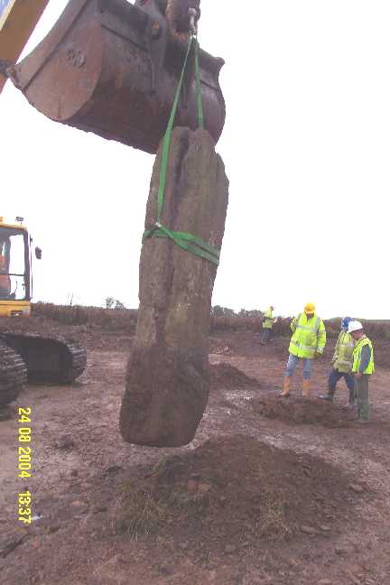
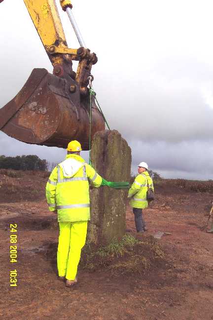
I got a prompt reply from Douglas Speirs at Fife Council, enclosing a very informative update note which he had prepared, of which the following is a slightly edited version. "The Bogleys Stone was a standing stone of Bronze Age date (c. 4,000 years old) that formerly stood in a field (NT 2950 9504) to the west of the A921 Kirkcaldy to Glenrothes road. It was the only upstanding element of what was believed was once a probable Bronze Age megalithic site. This standing stone is also known locally as the Sleeping Warrior, the Warrior's Grave, and the Dysart Standing Stone. For management purposes and to avoid the confusion caused through the use of different names, the site is identified in the Fife Sites and Monuments Record (FSMR) by the unique monument reference number: FF2948, but for ease, it is referred to as the Bogleys Stone because after its proximity to Bogleys Farm. In 1998, a proposal to extract coal on the site occupied by the stone was submitted. This was a complex application and involved the extraction of coal over a four year period followed by the subsequent restoration and re-development of the entire area. Prior to the determination of the application, the Council required the applicant, GM Mining, to submit an Environmental Assessment. As part of this Environmental Assessment, a desk-based archaeological assessment and field survey was conducted. Of eleven archaeological sites identified within the study area (Data Structure Report: Bogleys Farm, Kirkcaldy: Kirkcaldy and Dysart Parish, Desk-based Assessment and Field Survey, McGill, C. CFA Ltd, 1998), only the Bogleys Standing Stone was deemed by Fife Council to merit detailed examination and recording by means of archaeological investigation. Consequently, when consent to extract coal was granted, an archaeological condition was attached to the grant of consent which required the developer to engage the services of a professional archaeological contractor to expose, fully excavate and to record the archaeological deposits around and below the standing stone. The Excavation The need for this site to be excavated was prompted by the recognition of three facts: that the Bogleys standing stone potentially represented a larger, and possibly nationally important, prehistoric site; that the site would be completely destroyed by open-cast mining; and that there was no possibility of in-situ preservation. A programme of open area excavation incorporating an area of more than 400m2 around the standing stone was duly implemented in August, 2004. The excavation revealed that the stone stood within socket, 0.7 x 0.6m, which has been cut into the underlying solid sandstone bedrock to a depth of 0.9m. A pit containing cremated human bone was uncovered immediately adjacent to the stone whilst four further truncated (damaged) cremation pits were found c.20m to the NE of the stone, each containing burnt human bone and charcoal. Two further smaller pits were excavated and may represent the footings for an A-frame or similar engineering structure used to erect the stone. Ploughing had damaged the site but the excavation revealed that the stone had not previously been moved as had been suggested. Indeed, the stone had previously been rejected by Historic Scotland for scheduling as local accounts suggested that 19th century antiquarian investigations had excavated and possibly moved the stone, thus comprising the archaeological integrity of the site. Excavation proved that this had not happened and the site, although damaged by ploughing, was intact. A full account of the excavation of this site will be published in the Tayside and Fife Archaeological Journal later this year but suffice to say the excavations revealed that the Bogleys Stone is Bronze Age in date and based on revolutionary new radiocarbon dating techniques, was erected about 4,000 years ago (dates derived from cremated human bone samples dated by accelerator mass spectroscopy radiocarbon dating at The Center for Isotope Research in Gronningen, Netherlands). The stone is the last visible vestige of what must have been a highly charged area of ritual landscape that was a centre of prehistoric ritual activity in central Fife for over 1,000 years. The stone is massive, standing some 2m above ground and weighing more than 5 tons. Clearly the extraordinary degree of effort that went into moving and erecting this stone demonstrates the intensity of meaning that this site had to the Bronze inhabitants of central Fife. Exactly how the stone was used is not entirely clear, but archaeological excavations have shown that complex religious ceremonies, including the symbolic ritual burial of cremated human remains around the stone, were practised. The excavation process involved the complete removal of the stone. It was lifted and has been stored on pallets within a secure area within the development site since its excavation. However, as GM Mining is now in the final phases of site restoration and is due to leave the site for good in the next few months, the Council's Archaeological Unit is in the process of arranging to have the stone uplifted and removed to for safe storage at the Council's Roads Depot in Thornton. Moves are afoot to ensure that the redevelopment of the Kingslaw site is accompanied by planning conditions that will ensure that the stone is re-erected as close to its original position as is practicable. However, as the master plan for the site is not yet complete, it is not currently possible to say exactly where the stone will be re-erected and how it will relate to the new built environment around it. But it will be sensitively re-erected in a setting that will enable easy public access and interpretation." |
Posted by Trajan 22nd October 2008ce |
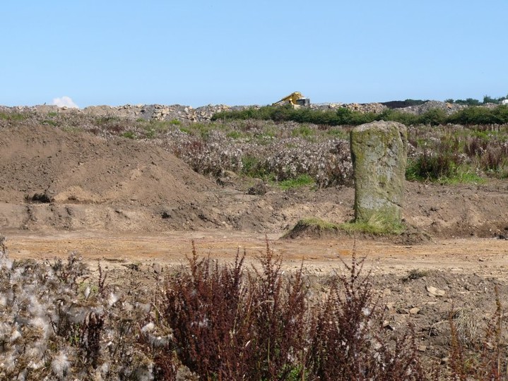
| The stone has still not been returned to its site. The open-cast area has been restored to rough grazing (two deer there on my visit), but the industrial estate has not been developed. I will ask the council archaeologist for an update and will post again if I learn anything new. |
Posted by Trajan 20th October 2008ce |
|
This stone has now been removed, but only temporarily. It wasn't scheduled since Historic Scotland deemed the site's archaeological importance to have already been compromised by excavation in 1854 when the stone was lifted so that underneath it could be examined. But when planning consent was given for the development of the site (open cast coal mining of 750,000 - 1,000,000 million tons over four years, followed by development as a retail and business park) it included the stipulation that the stone had to be re-set in its original position. The stone is currently in storage, and it's estimated it will be re-erected in about 3 years time. Unfortunately the plans show that there will be a roundabout on the stone's original site, so the county archaeologist faces the dilemma of putting it back there, or re-locating it close by so that the public still have access to it. |
 Posted by BigSweetie
9th September 2004ce Edited 9th September 2004ce |
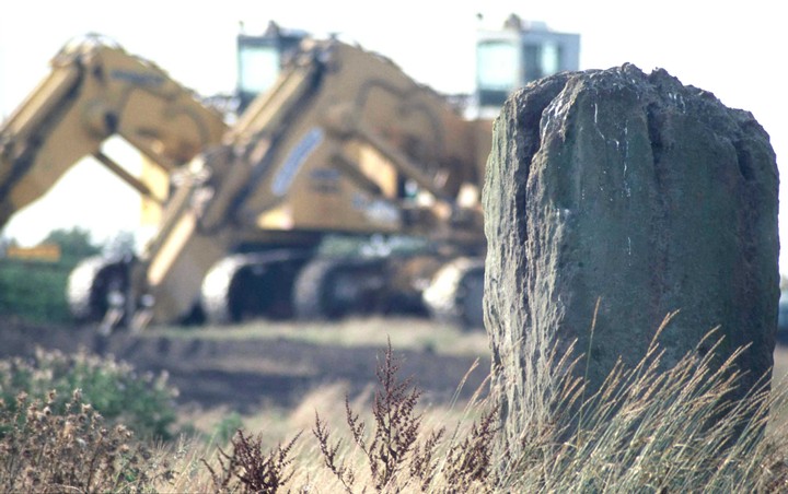
| Bogleys in August 2004 must be one of the saddest stones in Scotland. As luck would have it, the stone appears to have found itself in the middle of an open cast coal mine and its situation is much changed since just a year ago when the first pictures of it were submitted to the Modern Antiquarian. Now the stone may be seen presiding over mounds of earth, with construction diggers in the background. When the opencast mining stops, this 140 acre site is further earmarked for development as Fife's Kingdom Park - for "high quality retail, leisure and industrial use". |
Posted by nobut 22nd August 2004ce |
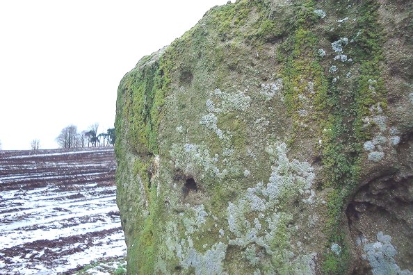
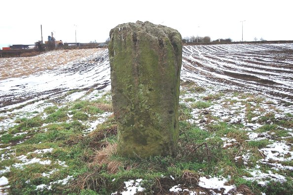
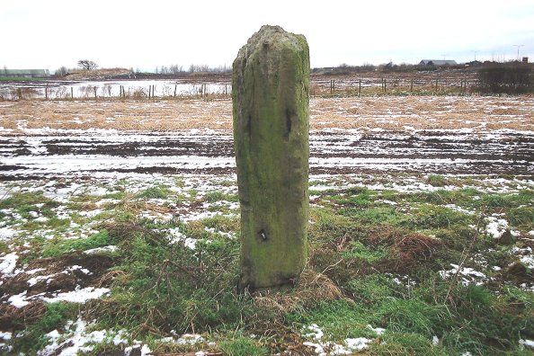
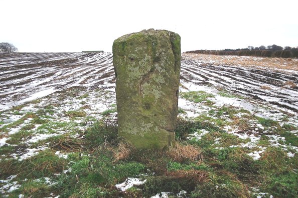
| I visited today. This stone stands in a field just on the eastern outskirts of Kirkcaldy, just where the A921 branches from the A92. Parking can be accomplished a couple of hundred metres along this road (a small layby). It is a large lump of sandstone standing just under 2m high, 1m wide, and about 0.6m thick, aligned E-W. There is one small cup mark high on the north face of the stone. |
 Posted by nickbrand
9th January 2003ce |
Links |
|
Stone PagesNews item from October 2004 |
Posted by Trajan 23rd October 2008ce |