The Modern Antiquarian
Log in
|
Register
Home
Latest Posts
Forums
Maps
Help
Browse Sites
News
Blog
Contributors
The Books
Select
-
Belgium
Denmark
Eire
France
Germany
Greece
Italy
The Netherlands
Norway
Portugal
Republic of Malta
Spain
Sweden
Switzerland
United Kingdom
County Cork
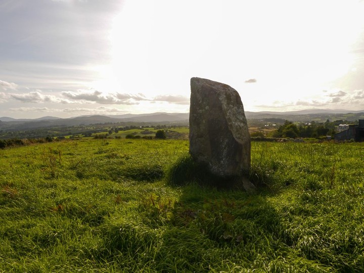
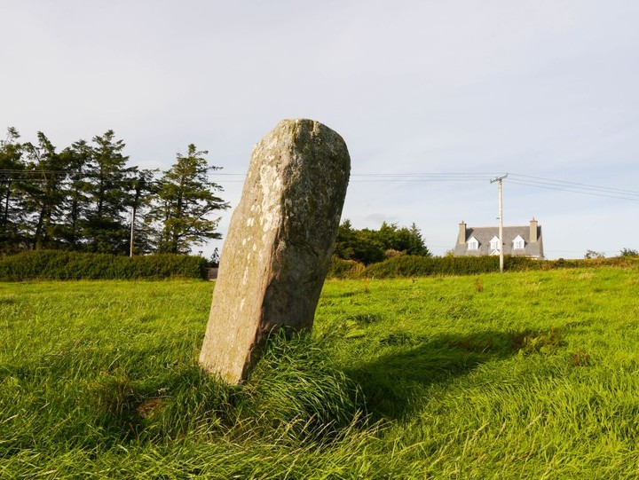
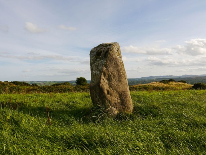
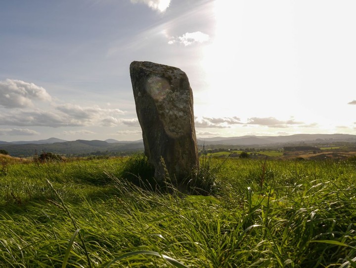
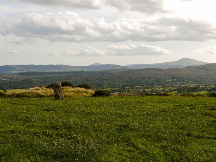
Ballyvoge 1
Standing Stone / Menhir
Ballyvoge 1 (Baile An Bhuaidh) (Standing Stone / Menhir) on The Modern Antiquarian, the UK & Ireland's most popular megalithic community website. 6 images, plus information on many more ancient sites nearby and across the UK & Ireland.
Image © Michael Mitchell
Also known as:
Baile An Bhuaidh
Nearest Town:
Cookstown (18km E)
OS Ref (IE):
W2672 /
Sheet: 79
Latitude:
51° 53' 43.51" N
Longitude:
9° 4' 30.39" W
Added by
Meic
Images (6)
0 discussions
Start a topic
Show |
Hide
Web searches for Ballyvoge 1
Flickr
Google
Google Images
The Megalithic Portal
Bing
Stone Pages
Wikipedia
Show map
(inline Google Map)
- Sites within 20 km -
-
Kylefinchin (0.82km E) (1 post)
Kylefinchin 2 (1.33km E) (5 posts)
Cools (1.7km WNW) (3 posts)
Inchinlinane (2.34km NE) (5 posts)
Lissacresig 2 (3.39km NNE) (5 posts)
Lissacresig 3 (3.39km NNE) (4 posts)
Lissacresig (3.42km NNE) (3 posts)
Lissacresig 1 (3.44km NNE) (4 posts)
Carrigaphooca (3.7km ENE) (7 posts)
Teergay (4.07km ESE) (8 posts)
Gortnalicky (5.54km NNE) (1 post)
Gortanimill (5.59km W) (16 posts)
Reananarree (5.64km W) (3 posts)
Reananerree (5.75km W) (11 posts)
Clashmaguire (5.91km NNE) (1 post)
Gortyleahy (6.08km E) (4 posts)
Ballymakeery (6.42km WNW) (5 posts)
Lack More (6.59km WSW) (9 posts)
Clashmaguire (6.79km NNE) (2 posts)
St Abban's Grave (6.87km WNW) (4 posts)
St Abban's Grave (6.87km WNW) (1 post)
Shanacloon (6.87km WNW) (5 posts)
Derryfineen (6.87km WSW) (5 posts)
Derryfineen (6.88km W) (6 posts)
Kilboultragh (7.11km ENE) (1 post)
Cabragh (7.53km N) (4 posts)
Gortnatubbrid (7.73km W) (13 posts)
Gortnatubbrid (7.73km W) (4 posts)
Carrigonirtane (7.83km N) (4 posts)
Cabragh (7.99km N) (4 posts)
Cabragh N (7.99km N) (6 posts)
Coolaclevane (8.56km SE) (3 posts)
Knockaunnagorp (8.71km SE) (0 posts)
Coolaclevane (8.75km SE) (3 posts)
Scrahanard (8.8km NE) (15 posts)
Turnaspidogy (8.89km SW) (8 posts)
Carrigonirtane (8.94km NNE) (6 posts)
Rossnakilla (8.96km ESE) (0 posts)
Rossnakilla (8.96km ESE) (9 posts)
Bealick (9km ENE) (3 posts)
Lackaduv (9.08km NE) (5 posts)
Knockraheen (9.24km NNE) (19 posts)
Knocknakilla (9.27km NNE) (0 posts)
Knockanereagh (9.79km SSE) (8 posts)
Knockane (10.17km ESE) (8 posts)
Bealick (10.24km ENE) (0 posts)
Barnadivane (10.93km ESE) (0 posts)
Reanacaheragh (10.94km ESE) (0 posts)
Glantane South (11.13km N) (8 posts)
Currahy (11.15km WSW) (4 posts)
Carriganimmy (11.18km NNE) (15 posts)
Glantane East S (11.58km N) (16 posts)
Gorteennakilla (11.96km WSW) (6 posts)
Caherbaroul (12.04km ENE) (7 posts)
Farrannahineeny (12.18km SSW) (16 posts)
Glantane East N (12.2km N) (14 posts)
Glantane East N (12.2km N) (5 posts)
Lumnagh More (12.21km W) (0 posts)
Rosnascalp (12.21km E) (4 posts)
Clearagh (12.3km E) (2 posts)
Moneygaff West (12.35km SE) (5 posts)
Glantane East (12.51km N) (7 posts)
Inchincurka (12.58km S) (15 posts)
Knocknakilla (12.83km NNE) (24 posts)
Knocknagappul (12.85km NE) (3 posts)
Keamcorravooly (12.95km WSW) (4 posts)
Knockagappul 1 (12.96km NE) (5 posts)
Keamcorravooly (12.98km WSW) (11 posts)
Coolmountain (13.08km SSW) (7 posts)
Kilberrihert large wedge tomb damaged (13.13km ENE) (2 posts)
Knockagappul 2 (13.3km NE) (6 posts)
Knocknagappul (13.33km NE) (3 posts)
Lackanashinagh (13.48km ESE) (0 posts)
Knocknagappul (13.87km NE) (5 posts)
Deelish (13.9km ENE) (4 posts)
Cloghboola Beg (13.92km NNE) (12 posts)
Stone Row, partially ruined (13.99km NE) (5 posts)
Laharankeal (14.09km ENE) (4 posts)
Knocknaneirk NE (14.14km ESE) (13 posts)
Garranereagh (14.18km ESE) (4 posts)
An Screathan Mór (14.18km WSW) (3 posts)
Hornhill (14.25km ESE) (8 posts)
Laharankeal (14.42km ENE) (1 post)
Knocknaneirk SW (14.44km ESE) (17 posts)
Knocknagappul (14.69km NNE) (2 posts)
Hornhill (14.83km ESE) (5 posts)
Western Pap (14.93km WSW) (9 posts)
Cloghboola More (14.97km N) (0 posts)
Cloghboola Beg (14.97km N) (0 posts)
Gortafludig (15.35km WSW) (0 posts)
Behagullane (15.38km SSE) (1 post)
Kinneigh (15.44km SE) (4 posts)
Carrigagulla NE (15.52km NE) (10 posts)
Carrigagulla (15.59km NE) (7 posts)
Bengour East (15.78km ESE) (6 posts)
Carrigagulla (15.8km NE) (20 posts)
Dooneens (15.82km SW) (4 posts)
Dooneens (16.16km WSW) (9 posts)
Carrigagulla NE (16.23km NE) (17 posts)
Grousemount (16.24km WSW) (3 posts)
Kilmeedy W (16.33km NNW) (0 posts)
Claragh E (16.37km NNW) (2 posts)
Kilmeedy E (16.37km NNW) (0 posts)
Oughtihery W (16.49km NE) (9 posts)
Claragh W (16.5km NNW) (2 posts)
Maulmore (16.71km NE) (8 posts)
Knockavullig SW (16.86km E) (4 posts)
Toom (16.86km SSE) (4 posts)
Bengour West (16.94km ESE) (6 posts)
Knockavullig NE (16.94km E) (2 posts)
Kinneigh (16.99km SE) (5 posts)
Inchireagh (17.07km SSW) (11 posts)
Currabeha (South) (17.12km E) (7 posts)
Oughtihery E (17.48km ENE) (9 posts)
Currabeha (North) (17.74km E) (7 posts)
Laravoolta 2 (17.75km ESE) (3 posts)
Derrynacaheragh (17.84km SSW) (2 posts)
Laravoolta 1 (17.89km ESE) (2 posts)
Bellmount Upper SW (18.42km E) (9 posts)
Eastern Pap (18.49km WNW) (6 posts)
Laughtneill (18.56km E) (9 posts)
Bellmount Upper NE (18.61km E) (9 posts)
Derrynasafagh (18.63km S) (3 posts)
Killaneer (18.75km ESE) (3 posts)
The Paps of Anu (18.83km WNW) (7 posts)
Dunmanway North (19.23km S) (5 posts)
Glenleigh (19.26km NNE) (3 posts)
Farnanes (19.35km SSW) (9 posts)
Nedinagh West (19.68km S) (3 posts)
Ballyhalwick (19.89km S) (3 posts)
Cappaboy Beg SE (19.95km SW) (7 posts)
- Add -
-
Add news
Add an image
Add fieldnotes
Add folklore
Add miscellaneous
Add a link
-
Add a site
Add a nearby facility
Add an alternative name/spelling
Images
(click to view fullsize)
Add an image
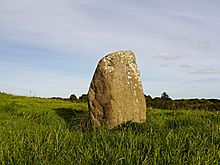 Image © Michael Mitchell