|
|

|
|
GefrinAncient Village / Settlement / Misc. Earthwork
|
||||||||||||||||||||||||
|
|
|
Images (click to view fullsize) |
|
|
Fieldnotes |
|
|
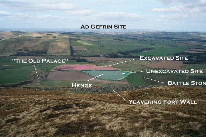
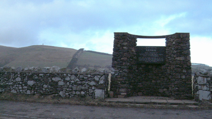
To the north of the Wooler to Kirknewton road, in a lay-by with the bulk of Yeavering Bell to the south, stands the Gefrin monument. The plaque tells us this was the site of Gefrin, but we look upon an empty field. Some sheep graze peacefully. Yet this is the site of, probably, one of the most important archaeological discoveries of the century. St. Bede in his Historia Ecclesiastica gives the township of Ad Gefrin its only real historical reference. Even then he is vague as to its actual location, saying only that it stands near to the river Glen in what is now known as the Glendale area. He links Ad Gefrin with the baptisms performed in the Glen by the missionary Paulinus in 627AD. In the thirteen centuries that have passed since, according to Bede, the palace was abandoned and with no visible evidence for its existence, Ad Gefrin became a place of legend. In 1949 Dr. J.K.St.Joseph, Curator in Aerial Photography at Cambridge University was looking for previously unknown Roman military sites in northern England. A severe drought made conditions ideal for aerial archaeology. As he flew over the Glendale area he noticed, and photographed, an impressive series of crop marks in an otherwise innocent field. More crop marks were seen further north near Milfield. In time a full aerial survey was made. Between 1953 and 1962 a detailed archaeological excavation to the site was undertaken led by Brian Hope-Taylor of Cambridge University. Although marks of buildings were observed to both the north and south of the present day road it was in the field to the north of the road where attention was focussed. Here the land rises and forms a gravel whaleback which would have stood clear of the marshy terrain present in the area when Gefrin was conceived. This area would have been the natural through route for travelers at the time. Today, with efficient field drainage, the Milfield. plane is a lot dryer than it once was. The excavations revealed a complex of great halls or palaces, some over eighty five feet in length, of timber construction and built to a very high standard. Ancillary buildings such as kitchens, a weaving shed and buildings with probable religious significance were identified. A large timber theatre or outdoor assembly building is one of the remarkable features of the site. The rotund nature of this structure has sparked the speculative and fanciful Arthurian link to Gefrin. Although there is evidence of older, Neolithic, remains on the site (burials and traces of a stone circle) it is thought work on Gefrin could have started in around 600AD. The site was in use for over 150 years and there were distinct phases of construction, the theatre, for example, being extended at one point from six to nine rows of seats, thereby doubling it's capacity. Some of the halls were modified and some demolished entirely. |
 Posted by BoC
31st March 2002ce Edited 10th October 2003ce |
|
Gefrin was the Royal Township of the Seventh Century Anglo Saxon Kings of Northumbria. The plaque tells how the missionary Paulinus preached Chritianity to the paople for 36 days and then baptised them in the nerby River Glen (or were they trying to end it all after 36 days of Jesus stuff being rammed down their throats.) pretty low lying for a settlement from then. I guess the rich arable land and the full river were the draws. Beautiful scenery near Kirknewton, pass this way to access the College Valley. |
 Posted by moey
23rd January 2002ce |
Miscellaneous |
|
|
Robin Fleming in her book 'Britain after Rome 400 to 1070' mentions that, this complex landscape of hillforts and Saxon royal palace was part of a ritual landscape. She goes on to say..... "that Bede did not mention that the king's hall and other major structures were erected in a straight line between the stone circle and the barrow and that the layout of the 'modern' seventh-century complex was thus determined by these ancient and enigmatic monuments" The Saxon complex seems to have had a 7 tiered theatre, and pits filled with ox heads, evidence of ritual use. The use of earlier prehistoric monuments such as barrows for instance were often used by these later settlements to add prestige to families and the small kingships that abounded at this time. |
 Posted by moss
1st November 2012ce |
Links |
|
Ad GefrinInformation on the Yeavering Bell hillfort ( http://www.gefrin.com/yeavering/yeavering.html ) and the Ad Gefrin site. The site now gives details on the hillforts in the College Valley. |
Posted by BoC 22nd March 2002ce Edited 3rd May 2011ce |