The Modern Antiquarian
Log in
|
Register
Home
Latest Posts
Forums
Maps
Help
Browse Sites
News
Blog
Contributors
The Books
Select
-
Belgium
Denmark
Eire
France
Germany
Greece
Italy
The Netherlands
Norway
Portugal
Republic of Malta
Spain
Sweden
Switzerland
United Kingdom
Wales
South Wales
Swansea & Neath Port Talbot
The Gower Peninsular
Pen-y-Gaer (Llanrhidian)
Enclosure
Pen-y-Gaer (Llanrhidian) (Enclosure) on The Modern Antiquarian, the UK & Ireland's most popular megalithic community website. 3 images, plus information on many more ancient sites nearby and across the UK & Ireland.
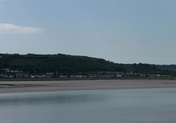
Image © A. Brookes (25.5.2013)
Nearest Town:
Llanelli (6km NW)
OS Ref (GB):
SS53659552 /
Sheet: 159
Latitude:
51° 38' 20.02" N
Longitude:
4° 6' 54.54" W
Added by
thesweetcheat
Images (3)
0 discussions
Start a topic
Show |
Hide
Web searches for Pen-y-Gaer (Llanrhidian)
Flickr
Google
Google Images
The Megalithic Portal
Bing
Stone Pages
Streetmap.co.uk
Wikipedia
Show map
(inline Google Map)
- Sites within 20 km -
-
Cil Ifor Top (4.41km SW) (16 posts)
Lethrid Tooth Cave (4.62km S) (1 post)
Pen-y-Crug (Llanrhidian) (4.87km SSW) (0 posts)
Llanrhidian (5.22km SW) (13 posts)
Cat Hole Cave (5.42km SSE) (17 posts)
Parc Le Breos (5.71km SSE) (43 posts)
Oldwalls (6.22km SW) (0 posts)
Maen Ceti (6.62km SW) (60 posts)
Cefn Bryn (East) (6.84km SSW) (22 posts)
Cefn Bryn Great Cairn (6.9km SW) (30 posts)
Samson's Jack (6.93km WSW) (13 posts)
Ty'r-coed (7.22km WSW) (7 posts)
Cefn Bryn (West) (7.25km SW) (10 posts)
Nicholaston long cairn (7.29km SSW) (20 posts)
Penmaen (7.43km S) (24 posts)
Crawley Rocks (7.76km S) (7 posts)
Stradey Wood (7.79km WNW) (2 posts)
Stembridge Camp (7.81km WSW) (0 posts)
Spurge Hole (8.28km SSE) (0 posts)
Bishopston Valley (8.38km SE) (12 posts)
North Hill Tor (8.49km WSW) (3 posts)
Minchin Hole (8.83km SSE) (0 posts)
Bacon Hole (9.01km SE) (10 posts)
Burry Standing Stones (9.03km SW) (14 posts)
Knelston (9.25km SW) (6 posts)
High Pennard (9.42km SE) (27 posts)
Cencoed (9.43km WNW) (0 posts)
Caswell Cliff (9.46km ESE) (7 posts)
The Bulwark (9.7km WSW) (28 posts)
Llanmadoc Hill (10.02km WSW) (30 posts)
Y Gaer (Burry Port) (10.26km W) (2 posts)
Maiden Castle (Gower) (10.39km S) (7 posts)
Hardings Down North Enclosure (11km WSW) (5 posts)
Hardings Down cairn (11km WSW) (3 posts)
Hardings Down East Fort (11.05km WSW) (8 posts)
Hardings Down West Fort (11.23km WSW) (13 posts)
Bryn Maen, Llannon (11.38km N) (1 post)
Rhossili Down settlement (12.65km WSW) (6 posts)
Sweyne Howes (north) (12.81km WSW) (28 posts)
Graig Fawr (12.85km NE) (11 posts)
Sweyne Howes (south) (12.94km WSW) (13 posts)
Rhossili Down (12.99km WSW) (36 posts)
Craig Llwyd and Court Wood (13.22km W) (2 posts)
Longhole Cave (13.47km SW) (11 posts)
Rockrose Cave (13.52km SW) (1 post)
Foxhole Slade (13.63km SW) (8 posts)
Paviland (13.74km SW) (34 posts)
Paviland Cave (13.81km SW) (67 posts)
Bryn-y-Rhyd (13.82km NNE) (1 post)
The Knave (13.84km SW) (18 posts)
Horse Cliff Fort (13.96km SW) (24 posts)
Graig Fawr (West) Enclosure (13.96km NE) (6 posts)
Red Fescue Hole (14.01km SW) (2 posts)
Mew Slade fort (14.02km SW) (1 post)
Burry Holms (14.03km WSW) (12 posts)
Red Chamber East (14.03km SW) (7 posts)
Mewslade Cave (14.1km SW) (7 posts)
Bon-y-Maen (14.15km ENE) (0 posts)
Thurba Camp (14.26km SW) (34 posts)
Lewes Castle (14.71km SW) (20 posts)
Old Castle (Rhossili) (14.81km WSW) (18 posts)
Y Naw Carreg (16.38km N) (0 posts)
Worm's Head (16.39km WSW) (21 posts)
Meini Hirion (Kidwelly) (17.8km WNW) (2 posts)
Meinillwydion (Llandyfaelog) (17.98km WNW) (12 posts)
Gwempa (18.04km WNW) (11 posts)
Gelli-bwch (18.3km E) (2 posts)
Castell Twby, Mynydd Llangyndeyrn (18.38km NW) (5 posts)
Mynydd Llangynderyrn Burial Chambers (18.46km NW) (17 posts)
Mynydd Llangyndeyrn (18.54km NW) (19 posts)
Maen Llwyd (Llangendeirne) (18.58km NW) (4 posts)
Mynydd Llangyndeyrn (Clos-yr-Yn) (18.6km NW) (6 posts)
Allt Cunedda (18.67km WNW) (2 posts)
Mynydd Gellionen (18.73km ENE) (10 posts)
Mynydd Carnllechart (19.07km NE) (8 posts)
Maen Bredwan (19.1km ENE) (10 posts)
Carn Llechart Burial Chamber (19.14km NE) (15 posts)
Penrhydd-wen (19.25km NE) (1 post)
Carn Llechart (19.37km NE) (54 posts)
Nant Moel (19.37km NE) (2 posts)
Bryn-chwyth (19.44km NE) (2 posts)
Bryn Mawr (19.86km NE) (1 post)
Warren Hill (19.95km E) (7 posts)
- Facilities within 20 km -
-
Swansea Tourist Inform... (Tourist Information: 12 km E)
- Add -
-
Add news
Add an image
Add fieldnotes
Add folklore
Add miscellaneous
Add a link
Add a nearby facility
Add an alternative name/spelling
Images
(click to view fullsize)
Add an image
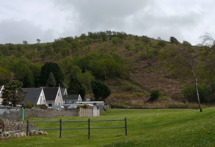
 Image © A. Brookes (25.5.2013)
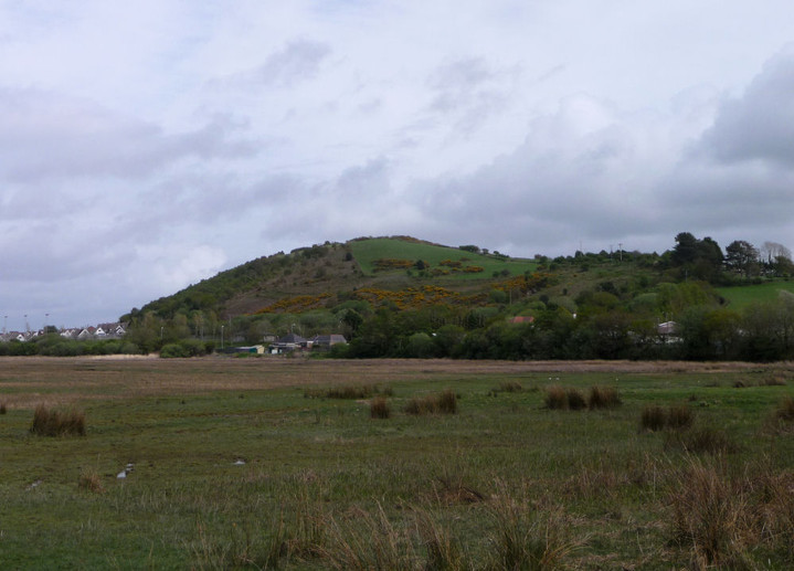