The Modern Antiquarian
Log in
|
Register
Home
Latest Posts
Forums
Maps
Help
Browse Sites
News
Blog
Contributors
The Books
Select
-
Belgium
Denmark
Eire
France
Germany
Greece
Italy
The Netherlands
Norway
Portugal
Republic of Malta
Spain
Sweden
Switzerland
United Kingdom
County Cork
Keilnascarta
Keilnascarta NW
Stone Row / Alignment
Keilnascarta NW (Stone Row / Alignment) on The Modern Antiquarian, the UK & Ireland's most popular megalithic community website. 5 images, 1 fieldnote, plus information on many more ancient sites nearby and across the UK & Ireland.
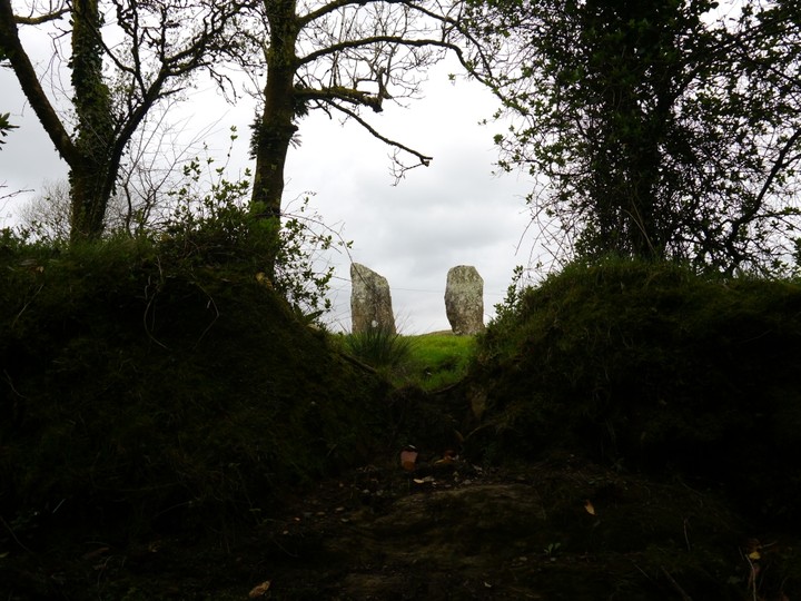
Image © Michael Mitchell
Nearest Town:
Bantry (4km N)
OS Ref (IE):
V993452 /
Sheets: 85, 88
Latitude:
51° 39' 1.54" N
Longitude:
9° 27' 18.48" W
Added by
Meic
Images (5)
Fieldnotes (1)
0 discussions
Start a topic
Show |
Hide
Web searches for Keilnascarta NW
Flickr
Google
Google Images
The Megalithic Portal
Bing
Stone Pages
Wikipedia
Show map
(inline Google Map)
- Sites within 20 km -
-
Keilnascarta (0.1km SSE) (5 posts)
Keilnascarta SE (0.2km SSE) (5 posts)
Parkana (1.08km SE) (3 posts)
Scartbaun (1.15km NE) (1 post)
Maulinward (1.41km S) (6 posts)
Maulinward (1.41km S) (6 posts)
Derreengreanagh (1.65km ENE) (11 posts)
Scartbaun (1.75km NNE) (5 posts)
Caherogullane (2.21km E) (5 posts)
Ballycommane (2.33km SW) (2 posts)
Ballycommane (2.33km SW) (3 posts)
Baurgorm SW (2.36km ENE) (1 post)
Cullomane West (2.49km ENE) (10 posts)
Knocknaveagh (2.9km NE) (4 posts)
Baurgorm (3.44km ENE) (11 posts)
Beach (3.46km WNW) (1 post)
Dromclogh (3.95km W) (5 posts)
Cullomane East (4.09km ENE) (6 posts)
Cullomane East (4.09km ENE) (7 posts)
Cullomane East (4.09km ENE) (3 posts)
Cullomane East (4.19km ENE) (3 posts)
Cullomane (4.19km ENE) (10 posts)
Cullomane East (4.29km ENE) (4 posts)
Dromourneen (4.38km E) (2 posts)
Trawlebane 2 (4.43km ENE) (5 posts)
Rooska East (4.98km WSW) (6 posts)
Trawlebane 1 (5.44km ENE) (7 posts)
Inchybegga (5.52km ENE) (2 posts)
Trawlebane (5.53km ENE) (15 posts)
Coolcoulaghta (6.37km SW) (5 posts)
Dromore School (6.59km ENE) (3 posts)
Ballybane (The Rock of the Rings) (6.95km SE) (4 posts)
Ballybane West NW (7.01km SE) (5 posts)
Gortnascreeny (7.47km ENE) (5 posts)
Glanbannoo Upper (7.79km NE) (7 posts)
Cappaghmore (7.84km ESE) (6 posts)
Glanbannoo Upper (7.91km NE) (3 posts)
Mount Corrin (8.01km SW) (7 posts)
Shandrum Beg (8.3km NNE) (5 posts)
Dunbeacon (8.46km SW) (6 posts)
Rathruane Beg (8.53km SSW) (4 posts)
Cloonygorman (8.53km NE) (3 posts)
Dunbeacon (8.9km SW) (20 posts)
Cappanaboul (8.97km NNE) (7 posts)
Rathruane More (9.25km SSW) (6 posts)
Toughraheen (9.27km ENE) (1 post)
Murrahin North (9.4km SE) (13 posts)
Murrahin North (9.52km SE) (8 posts)
Lissaclarig West (9.69km SE) (7 posts)
Derryarkane (10.33km NE) (0 posts)
Mill Little (11.39km NNW) (28 posts)
Breeny More (11.49km NNE) (30 posts)
Lyre (11.49km ESE) (6 posts)
Skeagh (11.72km ESE) (3 posts)
Foherlagh (11.9km ESE) (8 posts)
Kealkil (12km NNE) (45 posts)
Ardrah (12.03km NE) (20 posts)
Bawnishall (12.09km E) (3 posts)
Lissangle (12.13km E) (5 posts)
Cappaghnacallee (12.53km S) (1 post)
Kilbronoge (12.69km S) (12 posts)
Hollyhill (12.99km SE) (5 posts)
Rathcool (13.02km SSW) (6 posts)
Gortnacowly (13.12km NE) (15 posts)
Cloghboola (13.69km ESE) (5 posts)
Garranes North (13.83km ENE) (6 posts)
Canrooska (13.85km NW) (25 posts)
Maughanasilly (14.19km NNE) (23 posts)
Maughsilly (14.23km NNE) (1 post)
Lisheen Lower (14.31km SE) (4 posts)
Gorteanish (14.34km WSW) (14 posts)
Baurnahulla (14.41km ENE) (3 posts)
Barnagowlane West (14.46km NE) (9 posts)
Killenough (14.58km W) (5 posts)
Skull Stone (14.62km SSW) (5 posts)
Maughanaclea Centre (14.64km NE) (7 posts)
Cahermuckee (14.83km NE) (5 posts)
Abbeystrowry (15.11km ESE) (5 posts)
Illane (15.23km NNE) (7 posts)
Leitrim Beg (15.53km W) (21 posts)
Shronacarton (15.72km ENE) (6 posts)
Maughanaclea NE (15.73km NE) (9 posts)
Barraboy Mountain S (15.96km NW) (9 posts)
Barraboy Mountain N (15.96km NW) (6 posts)
Crossterry East (16.03km NW) (7 posts)
Inishbeg (16.11km SE) (5 posts)
Ballynahowen (16.25km W) (15 posts)
Coolnagarrane (16.38km ESE) (2 posts)
Goulacullin (16.46km ENE) (4 posts)
Barraboy Mountain (16.51km NW) (3 posts)
Barraboy Mountain (16.51km NW) (4 posts)
Clodagh (16.52km ENE) (19 posts)
Cousane (16.65km NE) (10 posts)
Clodagh Row (16.77km ENE) (12 posts)
Cullenagh (17.1km ENE) (11 posts)
Cousane (17.46km NE) (4 posts)
Farranamanagh (17.62km WSW) (2 posts)
Drumlave (17.68km W) (11 posts)
Cappaleigh North (17.84km W) (4 posts)
Kildromalive (17.84km W) (5 posts)
Derrynafinchin (17.94km NNE) (16 posts)
Cappaboy Beg (18.05km NE) (4 posts)
Farranamanagh (18.06km WSW) (6 posts)
Derrynafinchin (18.1km NNE) (1 post)
Cappaboy Beg (18.1km NE) (2 posts)
Dunmanus (18.12km SW) (3 posts)
Cullenagh (18.2km ENE) (9 posts)
Cappaboy Beg NW (18.28km NNE) (6 posts)
Cappaboy Beg (18.3km NE) (2 posts)
Cappaboy Beg (18.3km NE) (3 posts)
Cappaboy Beg SE (18.38km NE) (7 posts)
Arderawinny (18.65km SW) (10 posts)
Kilcaskan (18.82km W) (5 posts)
Feaghna (18.85km NNW) (10 posts)
Kilcrohane (18.86km WSW) (9 posts)
Milleens (19.01km NW) (3 posts)
Milleens (19.05km NW) (4 posts)
Dunmanus East (19.23km SW) (3 posts)
Barnabah (19.37km SE) (2 posts)
Farnanes (19.78km ENE) (9 posts)
Peakeen (19.88km WSW) (6 posts)
Toormore (19.9km SW) (15 posts)
Ballymacrown (19.94km SE) (6 posts)
- Add -
-
Add news
Add an image
Add fieldnotes
Add folklore
Add miscellaneous
Add a link
-
Add a site
Add a nearby facility
Add an alternative name/spelling
Images
(click to view fullsize)
Add an image
Fieldnotes
Add fieldnotes
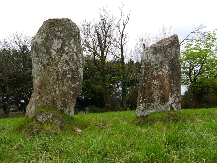
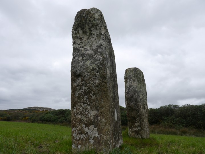
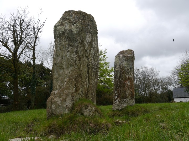
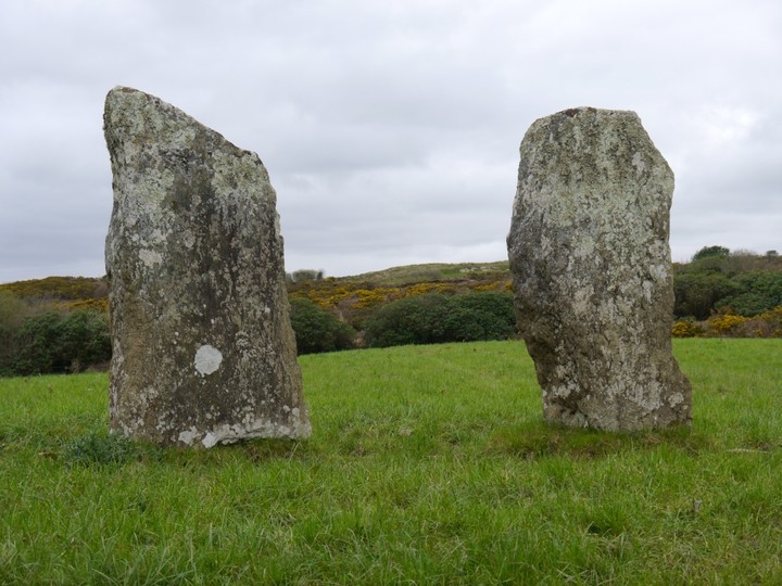
A wonderful stone pair. Both stones are 2.5 metres high and aligned NE-SW.
Access is the same as for the row, which lies about 50 yards away to the SE across the bohreen.
Comments (0)
|
Add a comment
|
Permalink
Posted by
Meic
21st March 2012ce

 Posted by Meic