The Modern Antiquarian
Log in
|
Register
Home
Latest Posts
Forums
Maps
Help
Browse Sites
News
Blog
Contributors
The Books
Select
-
Belgium
Denmark
Eire
France
Germany
Greece
Italy
The Netherlands
Norway
Portugal
Republic of Malta
Spain
Sweden
Switzerland
United Kingdom
England
Southern England
North Somerset, Bath and North-East Somerset
Walton Common
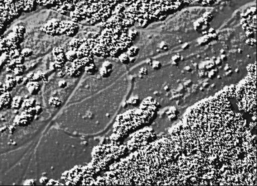
Hillfort
Walton Common (Hillfort) on The Modern Antiquarian, the UK & Ireland's most popular megalithic community website. 1 image, plus information on many more ancient sites nearby and across the UK & Ireland.
Image © Open Source Environment Agency LIDAR
Nearest Town:
Portishead (4km NE)
OS Ref (GB):
ST43087392 /
Sheets: 171, 172
Latitude:
51° 27' 39.07" N
Longitude:
2° 49' 9.86" W
Added by
Rhiannon
Images (1)
0 discussions
Start a topic
Show |
Hide
Web searches for Walton Common
Flickr
Google
Google Images
MAGIC
The Megalithic Portal
Bing
Stone Pages
Streetmap.co.uk
Wikipedia
Show map
(inline Google Map)
- Sites within 20 km -
-
Cadbury Camp (Nailsea) (2.77km E) (7 posts)
Portbury (7.37km ENE) (6 posts)
Cleeve Toot (8.64km SE) (5 posts)
Cadbury Hill (Congresbury) (9.03km SSE) (5 posts)
Gwent Levels (9.11km NW) (5 posts)
Goldcliff (9.77km WNW) (5 posts)
The Water Stone (11.81km ESE) (9 posts)
Redhill (12.43km ESE) (2 posts)
Felton Hill Longbarrow (12.46km ESE) (5 posts)
Winford Big Barrow (12.53km ESE) (1 post)
Ashton Court (12.6km E) (7 posts)
Winford Twin Barrows (12.61km ESE) (1 post)
Redhill (12.65km ESE) (2 posts)
Stokeleigh Camp (12.69km E) (39 posts)
Sand Point (13.03km SW) (6 posts)
Kings Weston Hill Barrows (13.16km ENE) (4 posts)
Kings Weston Hill (13.16km ENE) (15 posts)
Druid Stoke (13.17km ENE) (15 posts)
Burgh Walls (13.22km E) (3 posts)
Nempnett Thrubwell Horse Barrow (13.32km ESE) (1 post)
Clifton Down Camp (13.39km E) (27 posts)
Blaise Castle (13.41km ENE) (13 posts)
Llanfihangel Rogiet (13.89km N) (13 posts)
Wilcrick Hill (14.01km NNW) (12 posts)
Seven Sisters (14.04km ENE) (10 posts)
Bicknell Farm Round Barrow (14.06km ESE) (0 posts)
Redland Park (14.8km ENE) (6 posts)
Nempnett Thrubwell (15.02km ESE) (12 posts)
Banwell Fort (15.07km S) (3 posts)
Dolebury Warren (15.13km SSE) (25 posts)
Sudbrook (15.28km NNE) (34 posts)
Badock's Wood (15.3km ENE) (12 posts)
Worlebury (15.46km SW) (36 posts)
The Wimblestone (15.51km SSE) (11 posts)
Rowbarrow (15.68km SSE) (2 posts)
Banwell Bone Caves (15.84km SSW) (7 posts)
Rowberrow Warren (15.86km SSE) (7 posts)
Aveline's Hole (15.86km SE) (18 posts)
Nempnett Thrubwell Round Barrow (15.9km SE) (1 post)
Read's Cavern (15.92km SSE) (5 posts)
Stock Wood (15.97km NW) (3 posts)
Carrow Hill (16.04km N) (7 posts)
Burrington (Black Down) (16.04km SE) (10 posts)
Rowberrow Cavern (16.14km SSE) (1 post)
Heston Brake (16.56km NNE) (38 posts)
Langstone (16.57km NW) (4 posts)
Yarberry Farm (16.61km S) (13 posts)
King Offa's Tomb (16.83km ENE) (3 posts)
Five Lanes (Caerwent) (17.08km N) (3 posts)
Crick Barrow (17.11km NNE) (3 posts)
Black Down (Priddy) (17.37km SE) (11 posts)
Beacon Batch (17.53km SE) (23 posts)
Coed-y-Caerau (17.98km NW) (1 post)
Tyning's Farm (18.01km SSE) (1 post)
Loxton Hill Barrow (18.13km SSW) (1 post)
Ashbridge Farm (18.44km SSE) (1 post)
Castell Prin (18.49km NNW) (2 posts)
Llanvair-Discoed (18.51km N) (7 posts)
Maes Knoll (18.63km E) (34 posts)
Llanmelin Wood (18.81km N) (28 posts)
Gorsey Bigbury (18.87km SE) (8 posts)
Triple H Cave (18.96km SSE) (1 post)
Almondsbury Fort (19km ENE) (4 posts)
Middle Ham, Tynings (19.02km E) (2 posts)
Gwern-y-Cleppa (19.11km WNW) (17 posts)
Tredegar Fort (19.11km WNW) (26 posts)
Rhino Rift Barrow (19.17km SE) (6 posts)
The Devil's Stone (19.23km S) (12 posts)
Knowle Hill Settlement (19.27km ESE) (1 post)
Willis Hill (19.52km NNE) (6 posts)
Walborough (19.65km SW) (9 posts)
Gray Hill (19.68km N) (74 posts)
Hautville's Quoit (19.75km E) (14 posts)
The Cove (19.78km E) (61 posts)
The Great Circle, North East Circle & Avenues (19.92km E) (205 posts)
River Yeo Stone (19.95km S) (1 post)
Coed y Defaid (19.95km WNW) (2 posts)
The South West Circle (19.98km E) (34 posts)
Brean Down Fort (19.98km SW) (8 posts)
- Facilities within 20 km -
-
City Museum & Art Gall... (Museum: 15 km E)
Arches Hotel (Hotel: 15.7 km ENE)
Bristol Bookbarn (Library: 17.8 km E)
The Druids Arms (Pub: 19.8 km ESE)
- Add -
-
Add news
Add an image
Add fieldnotes
Add folklore
Add miscellaneous
Add a link
-
Add a site
Add a nearby facility
Add an alternative name/spelling
Images
(click to view fullsize)
Add an image