The Modern Antiquarian
Log in
|
Register
Home
Latest Posts
Forums
Maps
Help
Browse Sites
News
Blog
Contributors
The Books
Select
-
Belgium
Denmark
Eire
France
Germany
Greece
Italy
The Netherlands
Norway
Portugal
Republic of Malta
Spain
Sweden
Switzerland
United Kingdom
County Clare
The Burren
Ballyganner South
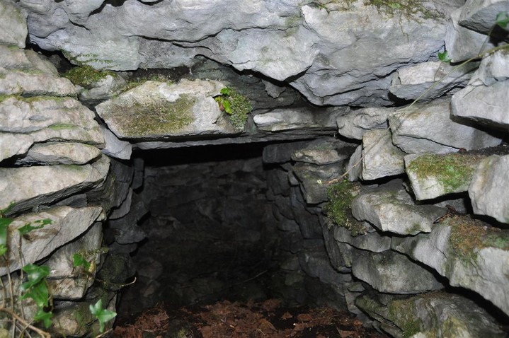
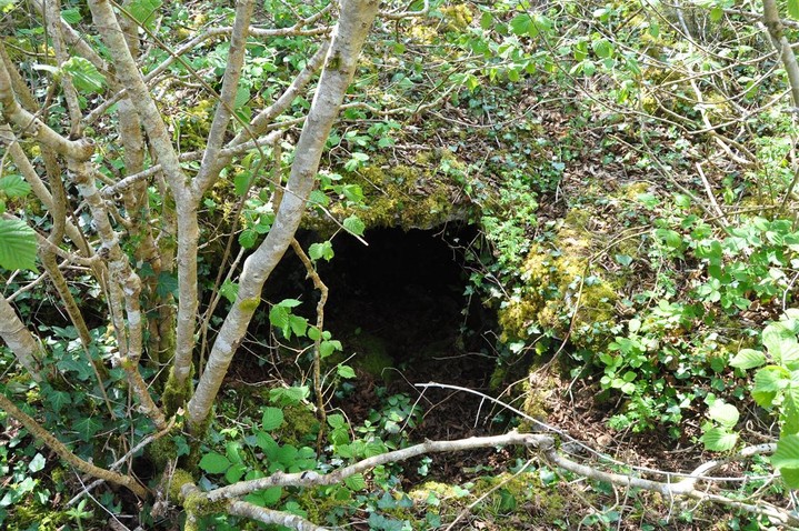
Souterrain
Ballyganner South (Souterrain) on The Modern Antiquarian, the UK & Ireland's most popular megalithic community website. 2 images, 1 fieldnote, plus information on many more ancient sites nearby and across the UK & Ireland.
Image © Charles Coughlan
OS Ref (IE):
Latitude:
52° 59' 57.41" N
Longitude:
9° 8' 54.89" W
Added by
bogman
Images (2)
Fieldnotes (1)
0 discussions
Start a topic
Show |
Hide
Web searches for Ballyganner South
Flickr
Google
Google Images
Bing
Stone Pages
Wikipedia
Show map
(inline Google Map)
- Sites within 20 km -
-
Ballyganner South II (0.45km NW) (0 posts)
Clooneen (0.67km SE) (6 posts)
Ballyganner North II (0.76km WNW) (6 posts)
Ballyganner South (1.02km WSW) (6 posts)
Ballyganner North III (1.13km N) (7 posts)
Ballyganner North (1.22km W) (6 posts)
Iskancullin (2.1km N) (1 post)
Carran (2.77km NNE) (3 posts)
Ballykinvarga (2.79km WSW) (0 posts)
Ballycasheen (3.07km ESE) (2 posts)
Parknabinnia (Cl. 60) (3.22km E) (0 posts)
Parknabinnia (Cl. 59) (3.26km E) (0 posts)
Cahermackirilla (3.3km NE) (3 posts)
Parknabinnia (Cl. 61) (3.3km E) (4 posts)
Fanyglavin (3.3km NE) (12 posts)
Parknabinnia (Cl. 62) (3.35km E) (0 posts)
Parknabinnia (3.44km E) (3 posts)
Parknabinnia (Cl. 69) (3.61km E) (3 posts)
Poulawack (3.62km N) (13 posts)
Parknabinnia (Cl. 153) (3.67km E) (7 posts)
Parknabinnia (Cl. 66) (3.69km E) (11 posts)
Commons North (Cl. 65) (3.7km E) (0 posts)
Poulawack II (3.73km N) (5 posts)
Poulawack Souterrain (3.83km N) (6 posts)
Parknabinnia (Cl. 67) (3.85km E) (27 posts)
Leana (Cl. 68) (3.99km E) (16 posts)
Commons North (Cl. 56) (4.1km E) (4 posts)
Leana (4.11km E) (7 posts)
Leana (4.14km E) (2 posts)
Leana (Cl. 57) (4.15km E) (3 posts)
Creevagh (4.58km ENE) (31 posts)
Caherconnell (4.65km N) (8 posts)
Lissylisheen (4.66km NW) (2 posts)
Moheramoylan (Cl. 30) (4.79km NNE) (1 post)
Meggagh (4.86km NE) (4 posts)
Baur South (5.21km NNW) (0 posts)
Baur South (Cl. 26) (5.33km NNW) (6 posts)
Baur South (5.44km NNW) (3 posts)
Cahercommaun (5.52km ENE) (22 posts)
Poulnabrone (5.53km N) (66 posts)
Baur South (5.63km NNW) (10 posts)
Baur North (5.63km NNW) (0 posts)
Tullycommon (6.03km ENE) (4 posts)
Cahermacnaghten (6.18km WNW) (5 posts)
Eanty More (6.53km NNE) (4 posts)
Ballymihil (6.64km NNE) (7 posts)
Castletown (6.69km ENE) (4 posts)
Tullycommon (Cl. 54) (6.69km ENE) (0 posts)
Slievenaglasha (6.85km ENE) (4 posts)
Gleninsheen (7.39km NNW) (10 posts)
Poulaphuca (7.64km NNE) (7 posts)
Berneens (8.1km N) (8 posts)
Gleninsheen (8.11km N) (20 posts)
Rannagh West (8.14km NE) (2 posts)
Cappaghkennedy (8.3km ENE) (1 post)
Ballytarsna (8.41km WSW) (2 posts)
Boloona (8.54km NNE) (4 posts)
Lissateeaun (8.9km W) (1 post)
Ballyallaban (9.6km NNW) (2 posts)
An Ráth (10km NNW) (6 posts)
Cahermore (10.21km NNW) (3 posts)
Curraghadoo (10.72km WSW) (4 posts)
Faunarooska (Cl. 4) (10.81km NW) (2 posts)
Faunarooska (Cl. 3) (10.86km NW) (2 posts)
Coolnatullagh (11.01km NE) (3 posts)
Faunarooska (Cl. 5) (11.02km NW) (4 posts)
Coolnatullagh (11.15km NE) (2 posts)
Coolnatullagh (11.43km NE) (2 posts)
Coolnatullagh (11.45km NE) (3 posts)
Derrynavahagh (11.66km NW) (12 posts)
Ballyelly Hut Site (13.4km WNW) (4 posts)
Ballyelly (13.4km WNW) (6 posts)
Turlough Hill/Knockycallanan (13.99km NNE) (7 posts)
Turlough Hill/Knockycallanan (14.13km NE) (11 posts)
Slievecarran (14.2km NE) (0 posts)
Moyree Commons (14.55km E) (10 posts)
Knockstoolery (15.25km W) (2 posts)
Doonmeave (15.51km WSW) (1 post)
Gleninagh North (15.89km NNW) (5 posts)
Doolin (16.21km W) (1 post)
Killian (16.25km E) (2 posts)
Doolin (16.26km W) (2 posts)
Doolin (16.28km W) (3 posts)
Teergonean (16.38km W) (11 posts)
Teergonean (16.43km W) (5 posts)
Doolin Stone Axe Production Site (16.5km W) (2 posts)
Caherphuca (17.84km E) (8 posts)
Caherdooneerish (17.93km NW) (4 posts)
Aughinish (18.94km N) (7 posts)
- Add -
-
Add news
Add an image
Add fieldnotes
Add folklore
Add miscellaneous
Add a link
-
Add a site
Add a nearby facility
Add an alternative name/spelling
Images
(click to view fullsize)
Add an image
Fieldnotes
Add fieldnotes
According to the land owner this little known souterrain is intact and accessible, located just off a track and easy to find, or miss if you are not careful :-)
Comments (0)
|
Add a comment
|
Permalink
Posted by
bogman
30th April 2011ce

 Posted by bogman