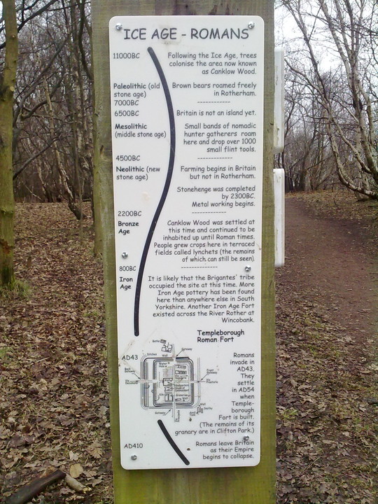
Log in
|
Register
Home
Latest Posts
Forums
Maps
Help
Browse Sites
News
Blog
Contributors
The Books
Select
-
Belgium
Denmark
Eire
France
Greece
Italy
The Netherlands
Norway
Portugal
Republic of Malta
Spain
Sweden
Switzerland
United Kingdom
England
Northern England
Yorkshire
South Yorkshire
Canklow Woods settlement
Ancient Village / Settlement / Misc. Earthwork
Canklow Woods settlement (Ancient Village / Settlement / Misc. Earthwork) on The Modern Antiquarian, the UK & Ireland's most popular megalithic community website. 1 image, plus information on many more ancient sites nearby and across the UK & Ireland.
No image available
Nearest Town:
Rotherham (2km NNW)
OS Ref (GB):
SK432907 /
Sheet: 111
Latitude:
53° 24' 39.57" N
Longitude:
1° 21' 0.11" W
Added by
megadread
Images (1)
Miscellaneous (1)
0 discussions
Start a topic
Show |
Hide
Web searches for Canklow Woods settlement
Flash Earth
Flickr
Google
Google Images
MAGIC
The Megalithic Portal
Bing
Stone Pages
Streetmap.co.uk
Wikipedia
Show map
(inline Google Map)
- Sites within 20 km -
-
Canklow Woods Rock shelter / Cave (0km N) (3 posts)
Wincobank (5.39km W) (11 posts)
Scholes Coppice (5.81km WNW) (18 posts)
Dead Man's Cave (11.92km ESE) (3 posts)
Ecclesall Woods (13.01km SW) (11 posts)
Burnt Hill Plantation (13.26km W) (7 posts)
Whitley Church (13.96km W) (2 posts)
Lob Wells Shelter (14.32km ESE) (1 post)
Ash Cabin Rock Fall cave / shelter (16.59km WSW) (2 posts)
Ash Cabin Flat (16.61km WSW) (6 posts)
Walder's Low (16.7km W) (9 posts)
Ash Tree Cave (16.72km SE) (3 posts)
Long Cist (16.83km WSW) (6 posts)
Ash Cabin Flat (16.83km WSW) (5 posts)
Cist II (16.83km WSW) (1 post)
Ring Cairn/Hut Circle (16.83km WSW) (1 post)
Ash Cabin Flat (16.83km WSW) (17 posts)
Bolster Stones (17.26km W) (4 posts)
Markland Grips (17.37km SE) (4 posts)
Stainborough Castle (17.65km NW) (5 posts)
Bole Hill Hillfort (17.71km SW) (2 posts)
New Hagg (17.72km WSW) (4 posts)
Head Stone (17.96km WSW) (12 posts)
Strawberry Lea (18.03km SW) (13 posts)
Brown Edge (18.5km SW) (20 posts)
Cowell Flat (18.55km W) (7 posts)
Ciceley Low (18.56km WSW) (5 posts)
Bar Dyke (18.94km W) (7 posts)
Bar Dyke Ring (19.12km W) (5 posts)
Apronful of Stones (Bradfield) (19.14km W) (2 posts)
Brierley (19.19km NNW) (6 posts)
Burbage Rocks (19.41km WSW) (2 posts)
Carl Wark & Hathersage Moor (19.45km WSW) (53 posts)
Creswell Crags (19.49km ESE) (51 posts)
South Kirkby (19.78km N) (8 posts)
Toad's Mouth (19.87km WSW) (3 posts)
Barbrook III (19.99km SW) (31 posts)
Hathersage Moor Ring Cairn (20km WSW) (5 posts)
- Facilities within 20 km -
-
Sheffield Museum (Museum: 10 km WSW)
Elm Tree Inn (Pub: 18.8 km SSE)
- Add -
-
Add news
Add an image
Add fieldnotes
Add folklore
Add miscellaneous
Add a link
-
Add a site
Add a nearby facility
Add an alternative name/spelling