The Modern Antiquarian
Log in
|
Register
Home
Latest Posts
Forums
Maps
Help
Browse Sites
News
Blog
Contributors
The Books
Select
-
Belgium
Denmark
Eire
France
Germany
Greece
Italy
The Netherlands
Norway
Portugal
Republic of Malta
Spain
Sweden
Switzerland
United Kingdom
County Carlow
Kilmagarvoge
Standing Stone / Menhir
Kilmagarvoge (Molly's Cross Roads) (Standing Stone / Menhir) on The Modern Antiquarian, the UK & Ireland's most popular megalithic community website. 1 image, plus information on many more ancient sites nearby and across the UK & Ireland.
Image © ryaner
Also known as:
Molly's Cross Roads
Nearest Town:
Tullow (5km SSW)
OS Ref (IE):
S870773 /
Sheet: 61
Latitude:
52° 50' 22.85" N
Longitude:
6° 42' 31.57" W
Added by
FourWinds
Images (1)
0 discussions
Start a topic
Show |
Hide
Web searches for Kilmagarvoge
Flickr
Google
Google Images
The Megalithic Portal
Bing
Stone Pages
Wikipedia
Show map
(inline Google Map)
- Sites within 20 km -
-
Tobinstown (2.05km E) (0 posts)
Rathmore (2.19km WNW) (0 posts)
Haroldstown (3.15km ENE) (38 posts)
Knockballystine (3.41km E) (0 posts)
Straboe (4.03km W) (0 posts)
Williamstown (4.96km ENE) (7 posts)
Patrickswell (5.18km NNE) (0 posts)
Rath Gael (5.19km ESE) (17 posts)
Rath East (5.38km ESE) (0 posts)
Rathglass (6.12km S) (0 posts)
Ardristan 2 (6.56km SSW) (0 posts)
Ardristan (6.61km SSW) (11 posts)
Tombeagh (7.66km ENE) (2 posts)
Glenoge (7.76km WSW) (2 posts)
Cloch An Phoill (Aghade) (8.15km SSW) (9 posts)
Ballynoe (8.22km S) (1 post)
Killenora (8.31km WSW) (0 posts)
Killabeg Stone (8.99km ESE) (0 posts)
Aghade (9.15km S) (4 posts)
Busherstown (9.34km WSW) (0 posts)
Clonmore (9.34km E) (3 posts)
Ardattin (9.5km SSE) (3 posts)
Bennekerry (9.6km WSW) (0 posts)
Craans (9.84km SSE) (6 posts)
Blacklion (9.96km SE) (0 posts)
Seskin (10.12km E) (0 posts)
Aghowle Lower (10.14km ESE) (3 posts)
Ballynavortha (10.68km SE) (2 posts)
Humewood Castle (10.78km NE) (4 posts)
Coolroe (11.47km SE) (3 posts)
Kilmurray (11.48km SSW) (0 posts)
Moylisha (11.52km SE) (8 posts)
Aghowle Upper (11.69km ESE) (5 posts)
Hughstown (11.94km NNW) (4 posts)
Rathcoran Hillfort (11.98km N) (3 posts)
Baltinglass Hill - Standing Stone (11.98km N) (1 post)
Baltinglass Hill - Tombs (11.98km N) (19 posts)
Baltinglass Hill Cairn - Standing Stone (11.98km N) (2 posts)
Baltinglass Hill - Cairn (11.98km N) (2 posts)
Baltinglass Hill 'Basin' Stone (12.06km N) (3 posts)
Baltinglass Hill (12.07km N) (2 posts)
Kilranelagh Graveyard (12.16km NNE) (6 posts)
Browne's Hill (12.46km WSW) (38 posts)
Tuckmill Hill (12.63km N) (3 posts)
Colvinstown Upper III (12.69km NNE) (2 posts)
Colvinstown Upper II (12.72km NNE) (2 posts)
Colvinstown Upper (12.77km NNE) (4 posts)
Kilranelagh (12.85km NNE) (0 posts)
Huntsman's Cross Road (12.91km SW) (0 posts)
Sragh (12.97km S) (0 posts)
Colvinstown (13.26km NNE) (3 posts)
Tinoran Hill (13.29km NNW) (0 posts)
Knockbower (13.48km SW) (0 posts)
Boleycarrigeen (13.62km NNE) (54 posts)
Carrig Mountain (13.99km NE) (0 posts)
Muckduff Upper 2/Carrig Mountain (14.07km NE) (4 posts)
Keadeen standing stone 2 (14.23km NE) (2 posts)
Keadeen (14.32km NE) (0 posts)
Keadeen (14.37km NE) (3 posts)
Keadeen (14.41km NE) (3 posts)
Muckduff Upper (14.49km NE) (5 posts)
Spinans Hill (14.87km NNE) (0 posts)
Brusselstown Ring (14.93km NNE) (21 posts)
Keadeen Cursus (14.97km NE) (5 posts)
Keadeen Mountain (15.05km NE) (4 posts)
Bolton Hill (15.29km WNW) (7 posts)
Eadestown North (15.64km NNE) (0 posts)
Knockbarragh (15.79km S) (0 posts)
Ballintruer More (16.02km N) (6 posts)
The Ballintruer Long Stone (16.02km N) (0 posts)
Knockbrack (16.18km S) (2 posts)
Knockbrack Cairns (16.24km S) (0 posts)
Clonegall (17.07km SE) (0 posts)
Castleruddery Lower (17.58km NNE) (4 posts)
Castleruddery (17.58km NNE) (48 posts)
Myshall (17.85km SSW) (3 posts)
Kildreenagh (18.26km SW) (5 posts)
Kildreenagh 2 (18.39km SW) (2 posts)
Coan (18.51km NE) (0 posts)
Kelshamore (18.7km NNE) (5 posts)
Lybagh (18.96km NE) (0 posts)
Rathoman (19.49km WSW) (0 posts)
- Add -
-
Add news
Add an image
Add fieldnotes
Add folklore
Add miscellaneous
Add a link
-
Add a site
Add a nearby facility
Add an alternative name/spelling
Images
(click to view fullsize)
Add an image
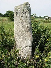 Image © ryaner

