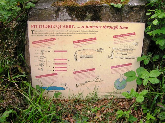
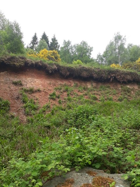
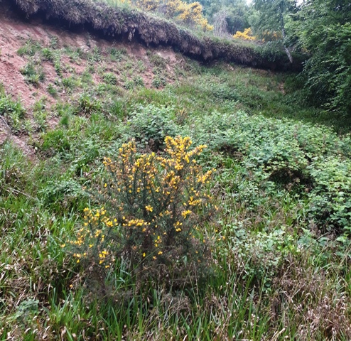
Log in
|
Register
Home
Latest Posts
Forums
Maps
Help
Browse Sites
News
Blog
Contributors
The Books
Select
-
Belgium
Denmark
Eire
France
Greece
Italy
The Netherlands
Norway
Portugal
Republic of Malta
Spain
Sweden
Switzerland
United Kingdom
Scotland
Aberdeenshire
Bennachie
Between Oxen and Little Oxen
Cup Marked Stone
Between Oxen and Little Oxen (Cup Marked Stone) on The Modern Antiquarian, the UK & Ireland's most popular megalithic community website. 2 images, 1 fieldnote, plus information on many more ancient sites nearby and across the UK & Ireland.
Image © drew/amj
Nearest Town:
Inverurie (11km E)
OS Ref (GB):
NJ66302266 /
Sheet: 38
Latitude:
57° 17' 36.05" N
Longitude:
2° 33' 33.18" W
Added by
drewbhoy
Images (2)
Fieldnotes (1)
0 discussions
Start a topic
Show |
Hide
Web searches for Between Oxen and Little Oxen
Flash Earth
Flickr
Google
Google Images
MAGIC
The Megalithic Portal
Bing
Stone Pages
Streetmap.co.uk
Wikipedia
Show map
(inline Google Map)
- Sites within 20 km -
-
Oxen Craig (0.02km SSE) (23 posts)
Socket Stone Rock (0.07km S) (4 posts)
Oxen Craig Peak (0.08km SSW) (4 posts)
Oxen Craig Peak 2 (0.09km S) (2 posts)
Oxen Craig South Western Descent (0.1km S) (16 posts)
Bennachie (0.12km WSW) (24 posts)
Little Oxen Craig (0.14km NNW) (6 posts)
Mither Tap (1.93km E) (47 posts)
Tillymuick (2.28km WNW) (8 posts)
Berryhill (2.67km N) (8 posts)
Berryhill (2.73km N) (6 posts)
Gouk Stane, Bennachie (3.14km E) (5 posts)
Gowk Stane, Oyne (3.34km NNE) (6 posts)
Kirkton Of Oyne (3.68km NE) (9 posts)
Millstone Hill East (3.72km E) (7 posts)
Westerton Of Petmathen (3.81km N) (10 posts)
Millstone Hill East 2 (4.06km E) (8 posts)
Newlands Of Oyne (4.15km NE) (2 posts)
Hatton of Ardoyne (4.15km NNW) (15 posts)
Burryhillock (4.23km WNW) (5 posts)
Mill of Carden (4.55km NE) (1 post)
Hill Of Knockollochie (4.73km ENE) (5 posts)
Druidstones (4.8km WSW) (16 posts)
Broadsea Farm (5.04km E) (6 posts)
Brownhills 2 (near Ardoyne) (5.29km NNW) (3 posts)
Brownhills (near Ardoyne) (5.34km NNW) (5 posts)
Hill Of Whitecross (5.34km E) (4 posts)
Cothiemuir Wood (5.4km WSW) (48 posts)
The Ark Stone (5.56km ESE) (4 posts)
Old Rayne (5.59km NNE) (31 posts)
Pitmachie (5.61km N) (4 posts)
Maiden Castle (5.62km NE) (8 posts)
Chapel O'Sink (5.7km ESE) (8 posts)
The Good Man's Fauld (5.79km W) (2 posts)
Hawk Hill (6.01km W) (9 posts)
South Lediken (6.36km NNW) (4 posts)
Wantonwells (6.52km WNW) (17 posts)
The Law (6.54km NE) (14 posts)
Satter Hill (6.67km WSW) (6 posts)
East Blairbowie (6.68km ENE) (6 posts)
The Barmkyn (6.88km WSW) (17 posts)
Hill Of Airlie (6.91km WSW) (7 posts)
Newton Stone (7.05km NNW) (1 post)
East Aquhorthies (7.12km E) (102 posts)
Balquhain (7.34km ENE) (25 posts)
Old Keig (7.34km WSW) (31 posts)
Deer Park (7.35km SE) (13 posts)
Dunnideer (7.51km WNW) (23 posts)
Braehead (7.62km W) (11 posts)
Hill Of Christ's Kirk (7.73km W) (9 posts)
Inschfield (7.77km WNW) (10 posts)
Durno (7.8km NE) (4 posts)
Dunnydeer Farm (7.93km WNW) (11 posts)
Luath's Stone (7.98km SSW) (13 posts)
Middleton (8.11km E) (3 posts)
Bowman Stone (8.22km NNE) (4 posts)
Bowman Stone 2 (8.23km NNE) (4 posts)
Drimmies (8.27km ENE) (5 posts)
Backley Hill 1 (8.27km NE) (8 posts)
Backley Hill (8.31km NE) (5 posts)
Knock Saul (8.33km W) (7 posts)
Hill Of New Leslie (8.33km W) (5 posts)
Backley Hill 2 (8.38km NE) (7 posts)
Nether Coullie (8.41km ESE) (3 posts)
Tombeg (8.5km SSE) (8 posts)
Liggars' Stane (8.52km ENE) (5 posts)
Mellenside (8.55km NNW) (8 posts)
Stonehead (8.56km WNW) (30 posts)
Dilly Hill 2 (8.59km E) (4 posts)
Crookmore (8.6km WSW) (2 posts)
Dilly Hill 3 (8.62km E) (4 posts)
The Ringing Stone (8.72km W) (6 posts)
Dilly Hill Cairn (8.72km E) (4 posts)
Dilly Hill (8.73km ENE) (4 posts)
Conglas (9.02km ENE) (5 posts)
Fallow Hill (9.16km NW) (5 posts)
Conglas 2 (9.17km ENE) (6 posts)
Baldyvin (9.18km SW) (4 posts)
Whitehills (9.34km S) (45 posts)
Culsalmond (9.6km NW) (3 posts)
North Rayne (9.62km NNE) (4 posts)
Candle Hill (9.64km WNW) (25 posts)
Brandsbutt (9.67km E) (19 posts)
Balhalgardy (9.7km ENE) (4 posts)
Druidsfield (9.78km WSW) (17 posts)
Langstane o' Craigearn (9.78km ESE) (11 posts)
Colpy (9.89km NW) (2 posts)
Mummer's Reive (10.15km NNW) (6 posts)
Wolf Stone (10.23km S) (10 posts)
Auchencleith (10.27km ENE) (6 posts)
Loanhead of Daviot (10.37km ENE) (68 posts)
Woodend of Cluny (10.41km SE) (8 posts)
Lumphart Hill (10.49km ENE) (7 posts)
New Craig (10.66km NE) (11 posts)
New Craig (10.78km NE) (14 posts)
Scotsmill (10.81km WSW) (6 posts)
Fallow Cairn (10.89km W) (4 posts)
Fallow Hill (10.9km W) (6 posts)
Bruce's Camp (11.13km E) (5 posts)
Cuning Hill (11.18km E) (8 posts)
Hill Of Rothmaise (11.23km N) (7 posts)
The Tow Stone (11.26km NNE) (5 posts)
Corrie (11.27km WSW) (6 posts)
Balgorkar (11.39km SE) (25 posts)
Newton Of Wardhouse Farm (11.42km WNW) (3 posts)
Lenchie (11.46km WNW) (4 posts)
Clovenstone Farm (11.49km E) (5 posts)
John Bells Stone (11.5km ESE) (3 posts)
Camies Stone (11.54km E) (6 posts)
Auld Kirk Of Alford (11.64km WSW) (11 posts)
Newton Of Wardhouse (11.69km WNW) (8 posts)
Tofthills (11.8km W) (9 posts)
North Strone (11.84km SW) (18 posts)
Broomend of Crichie (11.93km E) (54 posts)
Wardhouse (11.94km WNW) (5 posts)
Broomend (12km E) (6 posts)
Ardlair (12.14km W) (29 posts)
Findlatree (12.15km SW) (5 posts)
Gallow Hill (12.27km WSW) (9 posts)
Braeneil (12.3km ESE) (3 posts)
Cairnhall (12.92km E) (14 posts)
Hawk Law (12.96km ENE) (4 posts)
Hillhead Of Barra (13.01km ENE) (5 posts)
Lumphanan Hill (13.24km ESE) (5 posts)
Hill Of Selbie (13.43km ENE) (8 posts)
Little Hillbrae (13.49km ENE) (6 posts)
The Knock (13.49km ESE) (4 posts)
Nether Balfour (13.5km WSW) (2 posts)
White Hill (13.53km W) (6 posts)
Nether Lauchentilly (13.63km ESE) (5 posts)
South Leylodge (13.88km ESE) (20 posts)
Carnaveron (13.89km SW) (4 posts)
Kirkton of Bourtie (13.91km ENE) (30 posts)
Auld Kirk O' Tough (13.93km SSW) (10 posts)
Leylodge School (13.96km ESE) (4 posts)
Altar Stone, Hillhead (13.98km W) (2 posts)
Clatt Hillhead (13.99km W) (2 posts)
Balcairn (13.99km ENE) (3 posts)
Clatt Bankhead (14.04km W) (6 posts)
Wallace Stone (14.18km ENE) (3 posts)
Hill of Barra (14.18km ENE) (17 posts)
South Leylodge (14.24km ESE) (4 posts)
Old Kinnernie (14.32km SE) (6 posts)
Bruce's Seat (14.33km ENE) (4 posts)
Leylodge School 2 (14.34km ESE) (4 posts)
Piper's Stone (14.38km ENE) (6 posts)
Smallburn (14.42km W) (6 posts)
Craigievar (14.47km SW) (11 posts)
Corsindae (14.62km SSE) (4 posts)
Corsindae (14.67km SSE) (3 posts)
Tomnagorn (14.98km S) (20 posts)
Kintore Golf Club (15.01km E) (8 posts)
The Candy Stone (15.03km W) (5 posts)
Hill of Tuack (15.14km E) (12 posts)
Midmill (15.16km E) (11 posts)
Waterside (15.44km E) (9 posts)
Drumfours (15.45km SW) (6 posts)
Stoneyhill (15.59km E) (4 posts)
Nether Corskie (15.6km ESE) (9 posts)
Greenlands (15.65km E) (6 posts)
Corrstones (15.9km W) (17 posts)
Ferneybrae (16.03km E) (4 posts)
Cairn More (16.05km W) (4 posts)
Peat Hill (16.09km E) (4 posts)
Shieldon (16.1km ENE) (36 posts)
Wester Echt (16.12km ESE) (10 posts)
Little Fornet (16.13km ESE) (7 posts)
Peat Hill (16.16km E) (8 posts)
Orde's Cairn (16.21km SE) (4 posts)
Hillhead Of Suttie (16.26km E) (5 posts)
Upper Broomhill (16.26km SE) (4 posts)
Logie Newton (16.42km NNW) (8 posts)
Drumel Stone (16.57km W) (3 posts)
Midmar Kirk (16.62km SE) (62 posts)
Larrick (16.63km E) (6 posts)
Stonyfield (16.64km NW) (8 posts)
South Fornet (16.68km ESE) (8 posts)
Rhynie Graveyard (16.69km W) (6 posts)
Newton Wood (16.72km E) (1 post)
Mill of Noth (16.75km W) (10 posts)
Upper Third (16.75km N) (11 posts)
Barmekin Hill (16.75km SE) (24 posts)
Clashholm (16.76km SSW) (10 posts)
Bell Knowe (16.9km W) (5 posts)
Rhynie Standing Stones (16.95km W) (9 posts)
The Grinago Stone, Groaning Stone (17.1km ENE) (7 posts)
Cairntradlin (17.67km E) (3 posts)
Kinellar Kirkyard (17.81km E) (12 posts)
Leochel-Cushnie (17.82km SW) (4 posts)
Sunhoney (17.83km SE) (56 posts)
Auchaber (17.91km NNW) (5 posts)
Mill of Fintray Cursus/ Multiple Stone Rows / Avan (18.28km E) (1 post)
Newseat 2 (18.29km W) (4 posts)
Newseat (18.3km W) (9 posts)
Ord Hill (18.41km W) (8 posts)
Templand (18.43km W) (1 post)
Upper Ord (18.52km W) (12 posts)
Gouk Stone, Kinaldie (18.59km E) (5 posts)
Tillyching 2 (18.67km SSW) (3 posts)
Wheedlemont (18.7km W) (15 posts)
The Drum Stone (18.71km ESE) (5 posts)
Tillyching 1 (18.74km SSW) (5 posts)
Cairn Of Pitmansy (18.79km NE) (6 posts)
Fullerton/Bogcoup (18.8km NW) (3 posts)
Donald's Hillock (18.81km E) (6 posts)
Clochmaloo (18.92km W) (5 posts)
Burreldales (18.96km NNE) (5 posts)
Mote Hill (19.02km E) (7 posts)
Tap o' Noth (19.03km W) (48 posts)
Giant's Stone (19.21km W) (12 posts)
Cnoc Cailliche (19.24km W) (2 posts)
Wheedlemont (19.24km W) (8 posts)
Macbeth's Cairn (19.29km SSW) (9 posts)
Cairncoullie (19.39km WSW) (4 posts)
Brawland (19.42km W) (5 posts)
Sundayswells Hill (19.47km SSW) (4 posts)
Mill Of Brux (19.51km WSW) (4 posts)
The Slacks (19.61km E) (11 posts)
Newtongarry Hill (19.63km NW) (7 posts)
The Slacks (19.63km E) (4 posts)
Kildrummy Kirk (19.65km WSW) (4 posts)
The Peirk (19.66km W) (8 posts)
Lulach's Stone (19.7km WSW) (11 posts)
South Brideswell 2 (19.79km SW) (5 posts)
Little Clinterty (19.81km E) (4 posts)
South Brideswell (19.82km SW) (9 posts)
Elphhillock (19.82km WSW) (4 posts)
The Gouch Stone (destroyed?) (19.84km E) (1 post)
Learney (19.85km S) (2 posts)
Auchronie (19.86km ESE) (4 posts)
Tertowie (19.96km E) (5 posts)
- Facilities within 20 km -
-
Bridge of Muchalls (Bed & Breakfast: 10.6 km SE)
- Add -
-
Add news
Add an image
Add fieldnotes
Add folklore
Add miscellaneous
Add a link
-
Add a site
Add a nearby facility
Add an alternative name/spelling
Images
(click to view fullsize)
Add an image
Fieldnotes
Add fieldnotes
Just a short distance from the cairn, to the north, there is a rock with a solitary cup mark. Approx 10cm wide 4cm deep. To the right of the path when coming from Little Oxen.
Visited 3/06/2010
Comments (0)
|
Add a comment
|
Permalink
Posted by
drewbhoy
4th June 2010ce