The Modern Antiquarian
Log in
|
Register
Home
Latest Posts
Forums
Maps
Help
Browse Sites
News
Blog
Contributors
The Books
Select
-
Belgium
Denmark
Eire
France
Germany
Greece
Italy
The Netherlands
Norway
Portugal
Republic of Malta
Spain
Sweden
Switzerland
United Kingdom
County Tipperary
Garrangrena Lower
Hillfort
Garrangrena Lower (Hillfort) on The Modern Antiquarian, the UK & Ireland's most popular megalithic community website. 1 image, 1 fieldnote, plus information on many more ancient sites nearby and across the UK & Ireland.
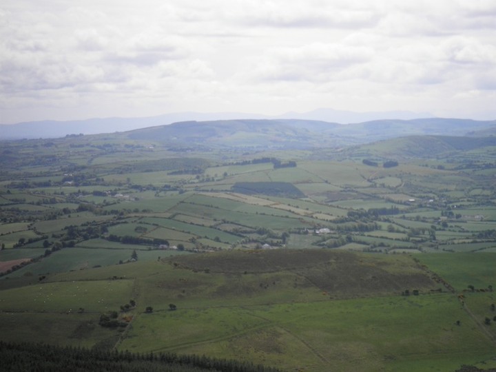
Image © Bawn79 © 2010
Nearest Town:
Borrisoleigh (4km SE)
OS Ref (IE):
S008699 /
Sheet: 59
Latitude:
52° 46' 48.72" N
Longitude:
7° 59' 17.32" W
Added by
bawn79
Images (1)
Fieldnotes (1)
0 discussions
Start a topic
Show |
Hide
Web searches for Garrangrena Lower
Flickr
Google
Google Images
The Megalithic Portal
Bing
Stone Pages
Wikipedia
Show map
(inline Google Map)
- Sites within 20 km -
-
Knockanora (1.31km N) (4 posts)
Ballinlough (5.02km NW) (2 posts)
Ballinlough (5.02km NW) (1 post)
Devilsbit Mountain (6.7km NE) (6 posts)
Pallas Upper (7.17km SE) (4 posts)
Killawardy (7.66km ENE) (3 posts)
Ballinacurra (8.27km WSW) (1 post)
Glastrigan (8.82km SW) (13 posts)
Toorfiba (9.08km SW) (3 posts)
Cooga (9.35km SSW) (2 posts)
Cooga (9.35km SSW) (4 posts)
Bendubh (9.87km NNE) (3 posts)
Knockcurraghbola Commons (10.49km SW) (22 posts)
Cooneen (10.58km WSW) (8 posts)
Cooneen (10.92km WSW) (3 posts)
Borrisnoe (10.92km NE) (2 posts)
Borrisnoe (10.92km NE) (5 posts)
Borrisnoe (10.92km NE) (2 posts)
Shevry (10.94km SSW) (1 post)
Shevry (11.03km SSW) (8 posts)
Foilnamuck (11.26km WSW) (5 posts)
Foilnamuck (11.47km WSW) (10 posts)
Knockcurraghbola Crowlands standing stone (12.13km SSW) (3 posts)
Knockcurraghbola Crowlands (12.32km SW) (1 post)
Knockcurraghbola Crowlands (central) (12.35km SW) (2 posts)
Knockcurraghbola Crowlands (west) (12.4km SW) (8 posts)
Knockcurraghbola Crowlands (east) (12.41km SW) (2 posts)
Graniera (12.41km SSW) (3 posts)
Reisk (12.91km SW) (1 post)
Knockmaroe (12.98km SW) (3 posts)
Rathfalla (13.74km WNW) (5 posts)
Knocknabansha (13.83km SW) (5 posts)
Cureeny Commons (14.01km WSW) (17 posts)
Castleleiny (14.14km ENE) (4 posts)
Knockalton Lower (14.22km WNW) (1 post)
Rathurles (14.25km WNW) (2 posts)
Rathurles (14.6km WNW) (9 posts)
Rathurles (14.62km WNW) (6 posts)
Loughbrack (14.68km SW) (11 posts)
Mauherslieve (15.56km WSW) (6 posts)
Mauherslieve (15.56km WSW) (1 post)
Middlewalk (16.03km NW) (3 posts)
Gorraun (16.35km NNW) (7 posts)
Bauraglanna (17.01km WSW) (9 posts)
Blackstairs (17.2km SW) (3 posts)
Blackstairs (17.2km SW) (4 posts)
Kilruane (17.3km WNW) (3 posts)
Goulmore (17.61km WSW) (4 posts)
Knockshanbrittas (A) (17.92km SW) (6 posts)
Aughsullish NW (17.92km SW) (1 post)
Garracummer (17.96km SW) (8 posts)
Aughsullish SW (18.06km SW) (6 posts)
Glencarbry (18.47km SSW) (1 post)
Baurnadomeeny (18.5km WSW) (4 posts)
Baurnadomeeny (18.77km WSW) (6 posts)
Tullahedy (18.78km W) (2 posts)
Baurnadomeeny (18.84km WSW) (38 posts)
Corravalley (19.6km NW) (3 posts)
Reardnogy More (19.6km WSW) (3 posts)
Foilycleara (19.89km SW) (3 posts)
Shanballyedmond (19.96km WSW) (17 posts)
- Add -
-
Add news
Add an image
Add fieldnotes
Add folklore
Add miscellaneous
Add a link
-
Add a site
Add a nearby facility
Add an alternative name/spelling
Images
(click to view fullsize)
Add an image
Fieldnotes
Add fieldnotes
This hill-fort isnt that prominent and cant be seen from the road below. I visited last Autumn but have had trouble locating the pictures from that visit. The hill is 315m high and the centre of the hill-fort is scrubby.
Comments (0)
|
Add a comment
|
Permalink
Posted by
bawn79
1st June 2010ce