The Modern Antiquarian
Log in
|
Register
Home
Latest Posts
Forums
Maps
Help
Browse Sites
News
Blog
Contributors
The Books
Select
-
Belgium
Denmark
Eire
France
Germany
Greece
Italy
The Netherlands
Norway
Portugal
Republic of Malta
Spain
Sweden
Switzerland
United Kingdom
England
Northern England
North Yorkshire
Middleton Moor
Middleton Moor 462
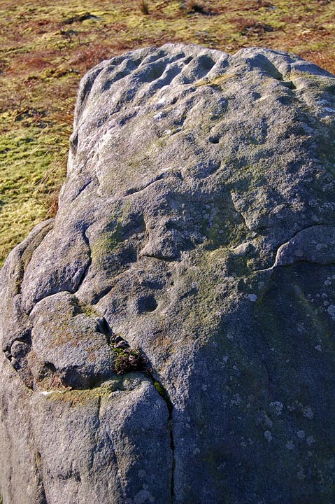
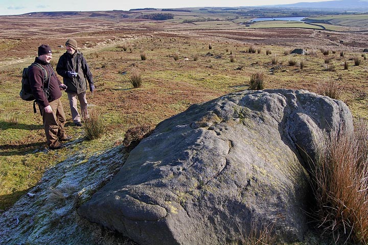
Cup and Ring Marks / Rock Art
Middleton Moor 462 (Cup and Ring Marks / Rock Art) on The Modern Antiquarian, the UK & Ireland's most popular megalithic community website. 2 images, plus information on many more ancient sites nearby and across the UK & Ireland.
Image © fitzcoraldo
Nearest Town:
Ilkley (4km S)
OS Ref (GB):
SE1128051674 /
Sheet: 104
Latitude:
53° 57' 38.64" N
Longitude:
1° 49' 41.02" W
Added by
fitzcoraldo
Images (2)
0 discussions
Start a topic
Show |
Hide
Web searches for Middleton Moor 462
Flickr
Google
Google Images
MAGIC
The Megalithic Portal
Bing
Stone Pages
Streetmap.co.uk
Wikipedia
Show map
(inline Google Map)
- Sites within 20 km -
-
Middleton Moor 458 (0.2km SW) (2 posts)
Middleton Moor 481 Latice Rock (0.29km E) (2 posts)
Middleton Moor 482 (0.39km E) (2 posts)
Middleton Moor 454 (0.47km SW) (1 post)
Middleton Moor 455 (0.47km SW) (1 post)
Middleton Moor 453 (0.47km SW) (1 post)
Middleton Moor 448 (0.53km SW) (4 posts)
Middleton Moor 437 (0.53km WSW) (2 posts)
Middleton Moor 446 (0.54km SW) (3 posts)
Middleton Moor 435 (0.54km WSW) (3 posts)
Middleton Moor 501 (0.92km ENE) (2 posts)
High Badger Gate (3.78km ENE) (5 posts)
Panorama Stone (4.37km SSE) (36 posts)
PRAWR 230-233 (4.77km S) (3 posts)
Willy Hall's Wood Stone (5.08km SSE) (23 posts)
The Swastika Stone (5.09km SSW) (25 posts)
Silver Well Cottage Stones (5.09km S) (1 post)
Weary Hill Stone (5.1km S) (10 posts)
Silver Well Stones (5.11km S) (5 posts)
WoodHouse Crag (5.12km SSW) (4 posts)
PRAWR 241 (5.13km S) (2 posts)
PRAWR 238 (5.14km S) (2 posts)
Cow and Calf Rocks (5.16km SE) (11 posts)
Graining's Head (5.19km S) (3 posts)
The Sepulchre Stone (5.19km SSW) (11 posts)
Pepperpot (5.19km SSE) (19 posts)
Hanging Stones (5.19km SE) (62 posts)
The Anvil Stone (5.2km SSW) (7 posts)
Black Beck Hole (5.23km SSW) (6 posts)
Barmishaw Stone (5.27km S) (21 posts)
Askwith Moor 512 (5.27km E) (1 post)
PRAWR 249 (5.28km S) (2 posts)
The Hardwick Stone (5.28km SW) (4 posts)
PRAWR 245 (5.3km S) (2 posts)
Neb Stone (5.36km S) (9 posts)
Hollin Tree Hill (5.39km E) (1 post)
Weary Hill Road (5.41km S) (3 posts)
PRAWR 242 (5.42km S) (2 posts)
PRAWR 272 (5.45km SE) (2 posts)
Little Badger Stone (5.47km S) (7 posts)
The Piper Crag Stone (5.48km SW) (5 posts)
Askwith Moor (5.51km E) (4 posts)
Hotel Stone (5.51km SE) (4 posts)
Addingham Crag Stone (5.52km SW) (9 posts)
The Planets (5.54km SE) (12 posts)
PRAWR 254 (5.57km SSE) (2 posts)
The Badger Stone (5.62km S) (48 posts)
Man Stone (5.62km E) (1 post)
PRAWR 298 (5.63km SE) (3 posts)
Backstone Beck West (5.65km SE) (17 posts)
PRAWR 255 (5.67km SSE) (2 posts)
PRAWR 256 Pitchfork stone (5.67km SSE) (0 posts)
Backstone Circle (5.72km SSE) (20 posts)
Counter Hill Barrow (5.74km WSW) (3 posts)
Backstone Beck 5 (5.74km SE) (3 posts)
Green Gates (5.77km SSE) (11 posts)
Pancake Rock (5.77km SE) (9 posts)
Backstone Beck Enclosure (5.77km SE) (20 posts)
Gill Head Standing Stone (5.78km SSE) (1 post)
Counter Hill (Addingham) (5.81km WSW) (0 posts)
Woman Stone, Askwith Moor (5.9km E) (1 post)
Askwith Moor 525 (5.94km E) (1 post)
Round Dikes (Addingham) (5.97km WSW) (5 posts)
Brandrith Crags (5.97km NE) (1 post)
Haystack (6.01km SE) (25 posts)
The Idol Stone (6.01km SE) (33 posts)
Green Crag Enclosure (6.11km SE) (21 posts)
Cowper's Cross (6.16km S) (2 posts)
Askwith Moor 533 (6.18km E) (1 post)
The Idol Rock (6.2km SE) (6 posts)
Coin Rock (6.33km SE) (2 posts)
Whetstone (6.37km SSE) (0 posts)
Askwith Moor 534 (6.37km E) (1 post)
Buck Stones - West (6.41km SSW) (8 posts)
Nixon's Station (6.47km SSE) (1 post)
Thimble Stones (6.48km S) (11 posts)
Scheduled Rock 25350 (6.51km SW) (3 posts)
The Doubler Stones (6.51km SW) (22 posts)
The Death's Head Rock (6.51km E) (4 posts)
Lanshaw Lass (6.55km SE) (2 posts)
The Twelve Apostles of Ilkley Moor (6.6km SSE) (83 posts)
Woofa Bank Enclosure (6.6km SE) (15 posts)
Lanshaw Stone (6.61km SE) (2 posts)
Lanshaw E (6.65km SE) (3 posts)
The Tree Of Life Rock (6.71km E) (10 posts)
Two Eggs (6.81km S) (5 posts)
Snowden Carr I (6.81km E) (3 posts)
Ashlar Chair (6.9km SSE) (8 posts)
Little Skirtful of Stones (6.94km SE) (4 posts)
Cold Stone (7.09km SE) (1 post)
Thief Thorn Standing Stone (Draughton Moor) (7.19km WSW) (2 posts)
Grubstones (7.34km SE) (14 posts)
Weston Moor (7.54km E) (2 posts)
Ellers Wood, Askwith (7.62km E) (2 posts)
Great Skirtful of Stones (7.7km SE) (9 posts)
Rivock Edge (8.1km SSW) (13 posts)
Bradup (8.12km SSW) (13 posts)
Stanbury Hill (8.37km S) (2 posts)
Horncliffe (8.41km SSE) (16 posts)
Bank Slack Camp (9.8km ENE) (1 post)
Skyreholme 426 (10km NNW) (1 post)
Skyreholme 421 (10.32km NW) (2 posts)
Skyreholme 422 (10.38km NW) (2 posts)
Skyreholme 418 (10.57km NW) (5 posts)
Skyreholme (10.63km NW) (3 posts)
Skyreholme (10.66km NW) (2 posts)
Skyreholme - Chopper's Stone (10.67km NW) (3 posts)
Skyreholme 415 (10.72km NW) (10 posts)
Skyreholme Walled Boulder (11.1km NW) (14 posts)
Low Bradley Moor (11.12km WSW) (5 posts)
Black Hill (11.15km WSW) (7 posts)
Skyreholme 404 (11.52km NW) (3 posts)
Skyreholme 401 (11.52km NW) (4 posts)
Skyreholme 407 (11.54km NW) (2 posts)
Upwood Hall (11.67km SSW) (1 post)
Baildon Stone 3 (11.71km SSE) (3 posts)
Baildon Moor Circle (11.72km SSE) (0 posts)
Baildon Stone 1 (Dobrudden) (11.81km SSE) (8 posts)
PRAWR 150 (11.82km SSE) (2 posts)
Dry Gill (11.97km NW) (5 posts)
Baildon Stone 2 (12.03km SSE) (5 posts)
Knotties Stone (Otley Chevin) (12.07km ESE) (5 posts)
Baildon Stone 4 (12.3km SSE) (4 posts)
Bull Stone (12.3km ESE) (11 posts)
Appletreewick (12.41km NW) (46 posts)
Brackenhall Circle (12.69km SSE) (7 posts)
Fertility Stone (Dacre) (12.8km NE) (2 posts)
Guisecliff Wood (12.87km NNE) (4 posts)
Fairy's Chest (13.3km W) (4 posts)
Harden Moor (13.46km SSW) (10 posts)
Fairy Stone (Cottingley) (13.83km S) (9 posts)
Nettlehole Ridge Stone Circle (14.11km W) (2 posts)
Catstones Ring (14.27km SSW) (8 posts)
Elbolton Hill (14.48km WNW) (1 post)
Dumpit Hill (14.79km WNW) (12 posts)
Hartwith Moor (14.8km NE) (14 posts)
Braisty Woods Stone (15.18km NE) (1 post)
Rocking stone (15.29km WNW) (0 posts)
Almscliffe Crag (15.6km E) (17 posts)
Druid's Cave Farm (15.82km NE) (3 posts)
Graffa Plains (15.94km NE) (1 post)
Hitching Stone (Keighley Moor) (16.01km SW) (4 posts)
Winter Hill Stone (16.15km SW) (1 post)
Riva Hill (16.29km NE) (1 post)
Brimham Rocks (16.38km NE) (78 posts)
Castlestead Ring (16.51km SSW) (2 posts)
Calverley Woods (16.61km ESE) (2 posts)
Yarnbury Henge (16.8km WNW) (8 posts)
Yeadon Crag Rock Shelter (17.21km NNE) (0 posts)
Grassington (17.37km NW) (5 posts)
Pin Stone (18.05km SE) (1 post)
Horsforth Low Hall Cup and Ring stone (18.45km ESE) (4 posts)
Horsforth Milestone (18.62km ESE) (3 posts)
Rectory Allotment (18.76km WSW) (6 posts)
Walton Head Monoliths (19.03km E) (1 post)
Silver Hill (19.31km SW) (1 post)
Bleara Lowe (19.64km WSW) (5 posts)
PRAWR 208 (Adel) (19.73km ESE) (4 posts)
Plague Stone (Adel) (19.73km ESE) (4 posts)
- Facilities within 20 km -
-
Cow & Calf Hotel (Pub: 5.6 km SSE)
Websters of Baildon (F... (Cafe: 12.5 km SSE)
- Add -
-
Add news
Add an image
Add fieldnotes
Add folklore
Add miscellaneous
Add a link
-
Add a site
Add a nearby facility
Add an alternative name/spelling
Images
(click to view fullsize)
Add an image
 Image © fitzcoraldo