The Modern Antiquarian
Log in
|
Register
Home
Latest Posts
Forums
Maps
Help
Browse Sites
News
Blog
Contributors
The Books
Select
-
Belgium
Denmark
Eire
France
Germany
Greece
Italy
The Netherlands
Norway
Portugal
Republic of Malta
Spain
Sweden
Switzerland
United Kingdom
England
Northern England
Northumberland
Camp Hill (Otterburn)
Hillfort
Camp Hill (Otterburn) (Hillfort) on The Modern Antiquarian, the UK & Ireland's most popular megalithic community website. 1 image, 1 fieldnote, 1 weblink, plus information on many more ancient sites nearby and across the UK & Ireland.
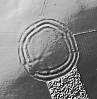
Image © Open Source Environment Agency LIDAR
Nearest Town:
Hexham (30km SSE)
OS Ref (GB):
NY9063193855 /
Sheet: 80
Latitude:
55° 14' 19.11" N
Longitude:
2° 8' 50.48" W
Added by
mascot
Images (1)
Fieldnotes (1)
Links (1)
0 discussions
Start a topic
Show |
Hide
Web searches for Camp Hill (Otterburn)
Flickr
Google
Google Images
MAGIC
The Megalithic Portal
Bing
Stone Pages
Streetmap.co.uk
Wikipedia
Show map
(inline Google Map)
- Sites within 20 km -
-
Fawdon Hill (1.03km W) (4 posts)
Woodhouse (6.4km SSW) (1 post)
Piper Shaws (7.14km NE) (1 post)
Five Kings (8.03km NE) (17 posts)
Tod Crag, Ottercops Moss (8.09km E) (21 posts)
Whitley Pike (8.33km WSW) (11 posts)
Brigantium (8.4km W) (9 posts)
Soldier's Fold (8.57km NE) (1 post)
HareHaugh Hillfort (8.62km NE) (5 posts)
Witchy Neuk (9.18km ENE) (5 posts)
Swindon Hill (9.19km NE) (0 posts)
Cross dyke, Campville (9.28km NNE) (0 posts)
The Five Barrows (9.37km NE) (0 posts)
Campville (9.58km NNE) (2 posts)
Lady's Well (Coquetdale) (10.16km NNE) (3 posts)
Woolaw Iron Age Settlement (10.17km W) (3 posts)
Ray-Sunnyside (10.4km SE) (19 posts)
Drake Stone (10.63km N) (10 posts)
Tosson Hill (10.75km ENE) (3 posts)
Fontburn Reservoir (11.53km E) (7 posts)
Fallowlees Burn (11.63km E) (10 posts)
Bellshiel (11.78km WNW) (1 post)
Barrowburn Wood (12.13km N) (0 posts)
Hawick (Bavington) (12.39km SE) (8 posts)
Fontburn Dod Wood (12.53km E) (38 posts)
Wolfershiel (12.54km ENE) (2 posts)
Bob Pyle's Studdie (12.59km ENE) (2 posts)
Carved stone (12.62km ENE) (1 post)
Fontburn (b) (12.63km E) (23 posts)
Simonside (12.65km ENE) (29 posts)
Little Church (13.19km ENE) (2 posts)
Castle Hills (13.31km N) (0 posts)
Tosson Burgh (13.34km ENE) (3 posts)
Alwinton-Clennel Cottages (13.44km N) (6 posts)
Dove Crags (13.82km ENE) (4 posts)
Tone Hall (13.94km S) (1 post)
Dour Hill (14.05km W) (3 posts)
Camp Knowe (14.08km N) (1 post)
Lowshield Green (14.25km S) (0 posts)
Thompson's Rock (14.75km ENE) (9 posts)
Pitland Hills (14.77km S) (9 posts)
Devil's Stone (Birtley) (14.89km S) (2 posts)
Three Kings (14.94km W) (32 posts)
Uplaw Knowe (14.99km N) (0 posts)
Roughlees (15.17km E) (4 posts)
Lordenshaws Hillfort (15.25km ENE) (12 posts)
Lordenshaw (15.25km ENE) (65 posts)
West Hills, Thropton (15.58km ENE) (7 posts)
Wallington Hall (15.61km ESE) (6 posts)
Old Rothbury (16.12km ENE) (4 posts)
Shillhope Law (16.14km NNW) (3 posts)
Paine's Bridge (16.15km ESE) (8 posts)
Chirnells Moor, Thropton (16.21km ENE) (4 posts)
Cartington Carriageway (a) (16.22km ENE) (2 posts)
Garleigh Hill (16.28km ENE) (6 posts)
Lordenshaws Cairns (16.5km ENE) (8 posts)
Football Cairn (16.65km ENE) (23 posts)
Rothbury (16.65km ENE) (6 posts)
Lordenshaws Standing Stone (16.76km ENE) (2 posts)
Football Cairn (e) (16.79km ENE) (7 posts)
North Lordenshaw (16.85km ENE) (15 posts)
Whitton Burn (17.09km ENE) (7 posts)
Spithope (17.14km W) (2 posts)
Cartington (17.33km NE) (5 posts)
Cartington Carriageway (b) (17.41km NE) (2 posts)
Addeyheugh (17.44km ENE) (9 posts)
Crocky's Heugh (17.73km ENE) (4 posts)
Warkshaugh Farm (17.74km S) (5 posts)
Middleton (17.78km ESE) (11 posts)
Cartington Hill (18.03km NE) (3 posts)
West Shaftoe (18.24km ESE) (6 posts)
Scrainwood (18.42km NE) (5 posts)
Hallion's Rock (18.5km ESE) (5 posts)
Cragside Cairn (18.59km ENE) (1 post)
Middleton Bank Top (18.66km E) (10 posts)
Salter's Nick (18.7km ESE) (7 posts)
Piper's Chair (18.99km ESE) (11 posts)
Netherwitton (19.1km E) (1 post)
Swinburne Terraces (19.27km SSE) (6 posts)
Great Swinburne (19.49km SSE) (15 posts)
The Poind And His Man (19.66km ESE) (13 posts)
Nunwick Park (20km S) (1 post)
- Add -
-
Add news
Add an image
Add fieldnotes
Add folklore
Add miscellaneous
Add a link
-
Add a site
Add a nearby facility
Add an alternative name/spelling
Images
(click to view fullsize)
Add an image
Fieldnotes
Add fieldnotes
Impressive defensive enclosure, listed as Iron Age in Keys to the Past. Around 80m across with what look like multiple entrypoints the triple ditch system shows up very well on Google Earth.
Comments (0)
|
Add a comment
|
Permalink
Posted by
mascot
16th April 2009ce
Links
Add a link
Keys To The Past Entry
Comments (0)
|
Add a comment
|
Permalink
Posted by
mascot
16th April 2009ce

 Posted by mascot