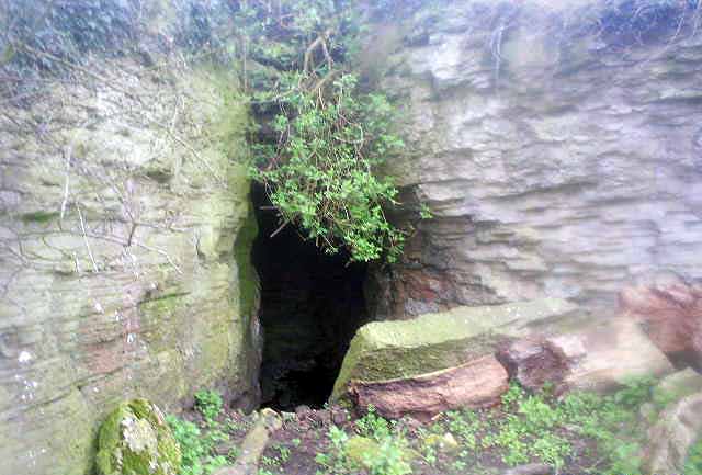
Log in
|
Register
Home
Latest Posts
Forums
Maps
Help
Browse Sites
News
Blog
Contributors
The Books
Select
-
Belgium
Denmark
Eire
France
Greece
Italy
The Netherlands
Norway
Portugal
Republic of Malta
Spain
Sweden
Switzerland
United Kingdom
England
Northern England
Derbyshire
Ash Tree Cave
Cave / Rock Shelter
Ash Tree Cave (Cave / Rock Shelter) on The Modern Antiquarian, the UK & Ireland's most popular megalithic community website. 2 images, plus information on many more ancient sites nearby and across the UK & Ireland.
Image © Neil Revill
Nearest Town:
Bolsover (6km SSW)
OS Ref (GB):
SK514761 /
Sheet: 120
Latitude:
53° 16' 44.48" N
Longitude:
1° 13' 44.54" W
Added by
stubob
Images (2)
Miscellaneous (1)
0 discussions
Start a topic
Show |
Hide
Web searches for Ash Tree Cave
Flash Earth
Flickr
Google
Google Images
MAGIC
The Megalithic Portal
Multimap 1:25000
Stone Pages
Streetmap.co.uk
Wikipedia
Show map
(inline Google Map)
- Sites within 20 km -
-
Markland Grips (0.95km SSW) (4 posts)
Creswell Crags (2.99km ESE) (48 posts)
Lob Wells Shelter (4.59km NNE) (1 post)
Langwith Basset Cave (6.7km SSE) (2 posts)
Dead Man's Cave (7.54km N) (3 posts)
Bothamsall Mound (15.83km E) (0 posts)
Ecclesall Woods (20km W) (10 posts)
- Facilities within 20 km -
-
Elm Tree Inn (Pub: 3 km S)
Chesterfield Library (Library: 14.2 km WSW)
Savilles Restaurant, R... (Restaurant: 17.4 km ESE)
- Add -
-
Add news
Add an image
Add fieldnotes
Add folklore
Add miscellaneous
Add a link
-
Add a site
Add a nearby facility
Add an alternative name/spelling
Images
(click to view fullsize)
Add an image
Miscellaneous
Add miscellaneous
Noted for its Later Upper Palaeolithic "Creswellian" artefacts the cave also contained material from the Mesolithic, Neolithic, Bronze Age, Iron Age and Roman eras.
Comments (0)
|
Add a comment
|
Permalink
Posted by
stubob
4th April 2009ce
Edited 10th May 2009ce