The Modern Antiquarian
Log in
|
Register
Home
Latest Posts
Forums
Maps
Help
Browse Sites
News
Blog
Contributors
The Books
Select
-
Belgium
Denmark
Eire
France
Germany
Greece
Italy
The Netherlands
Norway
Portugal
Republic of Malta
Spain
Sweden
Switzerland
United Kingdom
England
Southern England
Oxfordshire
Eynsham Park Camp
Hillfort
Eynsham Park Camp (Green Wood) (Hillfort) on The Modern Antiquarian, the UK & Ireland's most popular megalithic community website. 2 images, plus information on many more ancient sites nearby and across the UK & Ireland.
Image © Open Source Environment Agency LIDAR
Also known as:
Green Wood
Nearest Town:
Witney (5km SW)
OS Ref (GB):
SP393115 /
Sheet: 164
Latitude:
51° 48' 0.93" N
Longitude:
1° 25' 48.04" W
Added by
ginger tt
Images (2)
Miscellaneous (1)
1 discussion topic
Start a topic
Show |
Hide
Web searches for Eynsham Park Camp
Flickr
Google
Google Images
MAGIC
The Megalithic Portal
Bing
Stone Pages
Streetmap.co.uk
Wikipedia
Show map
(inline Google Map)
- Sites within 20 km -
-
Eynsham stone (4.54km E) (6 posts)
Eynsham Causewayed Enclosure (4.75km ESE) (1 post)
Deadman's Burial (4.76km ESE) (1 post)
Crawley (5.58km WSW) (1 post)
Cassington Big Ring (6.02km E) (1 post)
Bladon Camp (6.78km ENE) (3 posts)
Devil's Quoits (6.93km SE) (118 posts)
Grim's Ditch (7.78km NW) (1 post)
Churchill Copse Long Barrow (8.06km WNW) (5 posts)
Slatepits Copse Long Barrow (8.1km WNW) (11 posts)
Leafield Barrow (8.56km W) (5 posts)
Lowbarrow (8.76km W) (2 posts)
Waterman's Lodge Barrow (8.88km WNW) (1 post)
Wytham Hill (9.79km E) (1 post)
Ladihame Corner Long Barrow (10.21km W) (1 post)
Well Ground Long Barrow (10.54km WNW) (1 post)
Port Meadow Round Hill (10.72km E) (4 posts)
Ditchley Park Long Barrow (10.75km NNW) (1 post)
Thor Stone (11.02km NW) (25 posts)
Ascott Under Wychwood Barrow (11.18km W) (6 posts)
Shipton-Under-Wychwood Long barrow (11.21km W) (1 post)
The Hoar Stone (12.28km NNW) (57 posts)
Cleveley Marker Stone (12.7km NNW) (5 posts)
Hawk Stone (13.14km NW) (58 posts)
Five Shilling Corner Stone (13.34km WNW) (4 posts)
Whitehouse (13.42km E) (1 post)
Lyneham Longbarrow (13.55km WNW) (37 posts)
Lyneham Camp (13.62km WNW) (5 posts)
Lidstone Standing Stones (13.63km NW) (3 posts)
Knollbury Camp (13.82km WNW) (18 posts)
Enstone Long Barrow (13.98km NW) (1 post)
The Hoar Stone (Steeple Barton) (14.16km NNE) (8 posts)
The Hoar Stone II (14.97km NNE) (5 posts)
Cherbury Camp (15.3km S) (10 posts)
Churchill Three Stones (16.48km WNW) (8 posts)
Besbury Lane (16.57km WNW) (1 post)
Churchill Village Stones (16.62km WNW) (23 posts)
Churchill Standing Stone (17.28km WNW) (4 posts)
New Street Stone (17.46km NW) (10 posts)
Abingdon Causewayed enclosure (17.67km ESE) (2 posts)
Barrow Hills, Radley (18km ESE) (7 posts)
Drayton (18.13km SE) (1 post)
Idbury Camp (18.24km W) (5 posts)
Fifield (19.01km W) (2 posts)
Drayton Cursus (19.42km SE) (3 posts)
Ilbury Camp (19.58km N) (7 posts)
Greater Leys (19.88km E) (6 posts)
- Facilities within 20 km -
-
The Queens Head (Pub: 4.7 km ESE)
The Oxfordshire Museum (Museum: 7.4 km NE)
The Ashmolean Museum o... (Museum: 12.8 km ESE)
Museum of Oxford (Museum: 13.2 km ESE)
Arctic Fish Bar (Cafe: 17.6 km NW)
Annie's Country Pantry (Cafe: 17.7 km NW)
- Add -
-
Add news
Add an image
Add fieldnotes
Add folklore
Add miscellaneous
Add a link
-
Add a site
Add a nearby facility
Add an alternative name/spelling
Images
(click to view fullsize)
Add an image
Photographs:
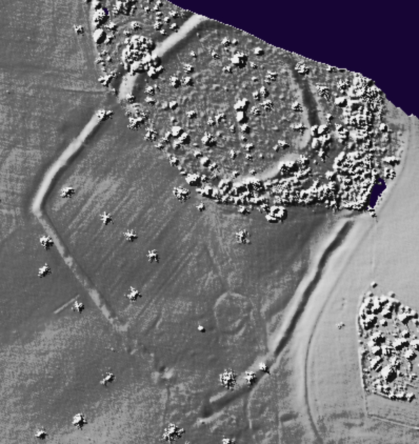
Maps / Plans / Diagrams:
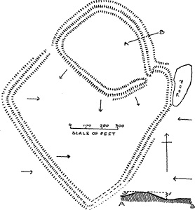
Miscellaneous
Add miscellaneous
Earthworks of an univallate Iron Age hillfort and attached annexe. Also Known as Green Wood fort
Comments (0)
|
Add a comment
|
Permalink
Posted by
ginger tt
3rd March 2009ce
Edited 8th March 2009ce