The Modern Antiquarian
Log in
|
Register
Home
Latest Posts
Forums
Maps
Help
Browse Sites
News
Blog
Contributors
The Books
Select
-
Belgium
Denmark
Eire
France
Germany
Greece
Italy
The Netherlands
Norway
Portugal
Republic of Malta
Spain
Sweden
Switzerland
United Kingdom
England
Southern England
Wiltshire
Stonehenge and its Environs
Gate Ditch
Ancient Village / Settlement / Misc. Earthwork
Gate Ditch (Ancient Village / Settlement / Misc. Earthwork) on The Modern Antiquarian, the UK & Ireland's most popular megalithic community website. 3 images, 1 fieldnote, plus information on many more ancient sites nearby and across the UK & Ireland.
Image © Jimit Sept 08
Nearest Town:
Wilton (12km S)
OS Ref (GB):
SU127426 /
Sheet: 184
Latitude:
51° 10' 54.93" N
Longitude:
1° 49' 5.81" W
Added by
jimit
Images (3)
Fieldnotes (1)
0 discussions
Start a topic
Show |
Hide
Web searches for Gate Ditch
Flickr
Google
Google Images
MAGIC
The Megalithic Portal
Bing
Stone Pages
Streetmap.co.uk
Wikipedia
Show map
(inline Google Map)
- Sites within 20 km -
-
Amesbury 11 Bell Barrow (0.51km SW) (7 posts)
Station Stones (0.62km SW) (3 posts)
Stonehenge (0.65km WSW) (483 posts)
Altar Stone (0.65km WSW) (5 posts)
Amesbury Bowl Barrow (0.72km ESE) (9 posts)
Stonehenge Car Park Post Holes (0.73km WSW) (12 posts)
The Avenue (0.8km E) (21 posts)
New King Barrows (0.8km E) (28 posts)
Old King Barrows (0.82km ENE) (27 posts)
Stonehenge Cursus Group (0.82km W) (46 posts)
Droveway Long Barrow (0.87km WSW) (1 post)
Oval Twin Disc Barrow (0.92km SW) (1 post)
Stonehenge Palisade (1.07km WSW) (12 posts)
Cursus Longbarrow (1.11km ENE) (10 posts)
Coneybury Henge (site) (1.22km ESE) (3 posts)
New Henge (To be named) (1.3km W) (1 post)
Stonehenge Urn (A303) Barrow Group (1.38km SW) (2 posts)
Strangways Group (1.43km NE) (2 posts)
Normanton Gorse Long Barrow (1.43km SW) (1 post)
King Barrow (Coneybury Hill) (1.49km ESE) (3 posts)
Fargo Plantation Henge (1.51km W) (3 posts)
Sun Barrow (1.56km SW) (1 post)
Monarch of the Plain (1.62km W) (11 posts)
Normanton Down and Bush Barrow (1.7km SW) (22 posts)
Bush Barrow (1.7km SW) (29 posts)
Durrington Down Group (1.77km NW) (6 posts)
Bluestonehenge (1.79km ESE) (8 posts)
The Stonehenge Cursus (1.82km W) (57 posts)
Larkhill Camp Long barrow (1.82km NNW) (4 posts)
Normanton Down Long Barrow (2km SW) (1 post)
Vespasian's Camp and Blick Mead (2.01km E) (29 posts)
Cuckoo Stone (2.02km ENE) (22 posts)
Normanton Down Neolithic Mortuary Enclosure (2.04km SW) (1 post)
The Lesser Cursus Henge (2.23km W) (1 post)
Lesser Cursus (2.37km W) (1 post)
Countess Farm (2.4km E) (1 post)
Durrington Walls (2.5km ENE) (42 posts)
Woodhenge (2.52km ENE) (50 posts)
Knighton Longbarrow (2.7km N) (12 posts)
Lake Group Earthwork (2.76km SW) (5 posts)
Fargo Compound Group (2.77km WNW) (1 post)
Winterbourne Stoke Group (2.84km WSW) (26 posts)
Winterbourne Stoke Long Barrow (2.9km WSW) (2 posts)
The North Kite Enclosure (2.91km SW) (1 post)
Wilsford Group (2.94km SSW) (1 post)
Prophet Barrow (2.94km SW) (8 posts)
Lake Group (3km SW) (14 posts)
Lake Group Long Barrow (3.07km SW) (1 post)
Ratfyn Barrow (3.19km E) (5 posts)
MOD Durrington (3.33km NE) (10 posts)
Lake Down Group (3.44km SSW) (1 post)
Winterbourne Stoke Down Long Barrow (3.54km W) (3 posts)
Bulford Longbarrow (3.58km ENE) (18 posts)
Amesbury Down (3.81km ESE) (1 post)
Lake House (3.96km SSE) (8 posts)
Boscombe Bowmen (3.97km E) (4 posts)
Robin Hood's Ball (4.16km WNW) (5 posts)
Amesbury Archer (4.21km E) (4 posts)
Winterbourne Stoke East Group (4.45km WSW) (2 posts)
Ogbury Camp (4.55km SE) (3 posts)
Bulford (4.81km ENE) (3 posts)
Winterbourne Stoke West Group (5.02km WSW) (2 posts)
Little Down (Great Durnford) (5.25km SSE) (1 post)
Ratfyn Barrow Group (5.36km E) (1 post)
Newton Barrow Group (5.74km E) (1 post)
Cowdown Farm (5.99km SSW) (1 post)
Gallows Barrow (6.12km NNE) (6 posts)
Berwick St James (6.48km WSW) (8 posts)
Bulford Camp Barrows (6.53km ENE) (1 post)
Sheer Barrow (6.98km NE) (1 post)
Milston Down Firs (7.09km ENE) (5 posts)
Net Down (7.31km NW) (1 post)
Newton Barrow (7.43km SSW) (2 posts)
Silk Hill (7.75km ENE) (2 posts)
Milston Down Barrow Group (8.36km ENE) (2 posts)
Wilbury House (8.98km E) (2 posts)
Enford (9.1km N) (5 posts)
Devil's Ditch (9.15km ENE) (8 posts)
Winterbourne Gunner Group (9.28km ESE) (2 posts)
Silver Barrow (9.35km W) (10 posts)
Horse Barrow (9.36km ESE) (1 post)
Slay Barrow (9.43km NW) (1 post)
Yarnbury Castle (9.43km WSW) (29 posts)
Milston Down Long Barrows (9.57km ENE) (21 posts)
East Down Long Barrow (9.59km WNW) (2 posts)
Ebsbury Hill (9.72km SW) (2 posts)
Old Sarum (9.94km SSE) (46 posts)
Dunch Hill Barrow (10.07km NE) (9 posts)
White Barrow (10.27km W) (12 posts)
Ell Barrow (10.28km NW) (1 post)
Old Coach Road Barrows (10.37km NE) (3 posts)
Grovely Castle (10.38km SW) (4 posts)
Figsbury Ring (10.69km ESE) (45 posts)
Laundry Bungalows (10.79km E) (1 post)
Seven Barrows (Tidworth Camp) (10.96km NE) (5 posts)
Casterley Camp (10.96km NNW) (4 posts)
Battery Hill (10.99km ESE) (1 post)
Old Ditch Longbarrow (11.18km W) (22 posts)
Hot Cross Bun (11.44km NE) (4 posts)
Lidbury Camp (11.44km NNE) (1 post)
Chisenbury Camp (11.53km N) (1 post)
Comesdeane Well Long Barrow (11.54km NE) (5 posts)
East Castle (11.6km SW) (4 posts)
Tilshead Lodge Longbarrow (11.64km W) (13 posts)
Barrow Field Clumps (11.66km E) (4 posts)
Sidbury Hill (11.87km NE) (5 posts)
Weather Hill Long Barrow (11.97km NE) (1 post)
Fussell's Lodge (11.99km ESE) (6 posts)
Easton Down (12.67km E) (2 posts)
Weather Hill (12.72km NE) (9 posts)
Martin's Clump (12.96km E) (2 posts)
Martin's Clump Mine (13.02km E) (1 post)
Snail Down (13.2km NE) (6 posts)
Grant's Firs Group (13.22km NNE) (1 post)
Bilbury Rings (13.3km WSW) (1 post)
Broadbury Banks (13.38km NW) (2 posts)
Cow Down (Tidworth) (13.51km NE) (3 posts)
Quarley Hill (13.56km E) (5 posts)
Church End Ring (13.56km WSW) (1 post)
Kill Barrow (13.71km W) (1 post)
Hanging Langford Camp (13.72km WSW) (2 posts)
Southly Bridge Barrows (13.98km NE) (5 posts)
Pickpit Hill Barrow (14.02km ENE) (2 posts)
Cobhill Barrow (14.14km ESE) (2 posts)
Rowbarrow (Salisbury) (14.34km SSE) (1 post)
Suddern (14.51km E) (1 post)
Ludgershall 2 (14.53km NE) (7 posts)
Windmill Hill (Ludgershall) (14.53km NE) (3 posts)
King Ina Earthworks (Eastern section) (14.59km NE) (3 posts)
Everleigh Barrows (14.6km NNE) (14 posts)
Codford Circle (14.6km WSW) (2 posts)
Ludgershall 1 (14.61km NE) (7 posts)
Pheasant Hotel (14.75km ESE) (1 post)
Summer Down (14.92km NE) (17 posts)
Down Farm Group (15.24km NNE) (5 posts)
Ashleys Copse (15.32km E) (2 posts)
Marden Henge (and Hatfield Barrow) (16.02km NNW) (34 posts)
Oldhat Barrow (16.11km NNE) (14 posts)
Sherrington Long Barrow (16.23km WSW) (2 posts)
Wick Ball Camp (16.49km SW) (1 post)
Castle Barrow (16.69km W) (1 post)
Knook Castle (16.7km W) (1 post)
Giant's Grave (Milton Hill) (16.82km NNE) (18 posts)
Sherrington Motte (16.99km WSW) (3 posts)
Knook Barrows (17.14km W) (2 posts)
Upton Great Barrow (17.15km WSW) (4 posts)
Woodborough Holed Stone (17.29km NNW) (6 posts)
Godsbury (17.61km NNE) (5 posts)
Boyton Down Round Barrow (17.89km WSW) (3 posts)
Swanborough Tump (17.9km N) (9 posts)
Boyton Down Long Barrow (17.92km WSW) (3 posts)
Pewsey (17.94km N) (9 posts)
The Hanging Stone (18.1km NNW) (6 posts)
Chiselbury (18.11km SW) (15 posts)
Pewsey Church (18.17km N) (8 posts)
Golden Barrow (destroyed) (18.41km WSW) (8 posts)
Clearbury Ring (18.46km SSE) (1 post)
Picked Hill (18.49km NNW) (13 posts)
Easton Clump (18.63km NNE) (3 posts)
Imber (18.7km W) (4 posts)
Weyhill (18.99km ENE) (2 posts)
Boles Barrow (18.99km W) (4 posts)
Whiteshoot Hill (19km E) (2 posts)
Fairmile Down (19.07km NE) (21 posts)
The Turret (19.11km E) (2 posts)
Ridgeway (Southernmost Remains) (19.27km NNW) (9 posts)
Alton Priors (19.58km NNW) (20 posts)
Corton Long Barrow (19.66km WSW) (6 posts)
Brade Wyll (19.72km NNW) (3 posts)
Grafton Disc Barrows (19.77km NE) (7 posts)
Whitsbury Down Long Barrow (19.94km S) (2 posts)
Danebury North-East long barrow (19.97km E) (1 post)
Giant's Grave (Downton) (19.98km SSE) (2 posts)
- Facilities within 20 km -
-
Travelodge Amesbury St... (Motor Lodge: 2.6 km E)
Amesbury Friar Tuck Cafe (Cafe: 2.9 km ESE)
Cafe in a bus (Cafe: 9.4 km SW)
The Camping and Carava... (Camping Site: 10.7 km SSE)
Wyndham Arms (Pub: 12.4 km SSE)
Salisbury (Youth Hostel: 12.9 km SSE)
Salisbury and South Wi... (Museum: 13.3 km SSE)
The Millstream (Pub: 15.8 km NNW)
The Barge Inn (Pub: 19.2 km NNW)
- Add -
-
Add news
Add an image
Add fieldnotes
Add folklore
Add miscellaneous
Add a link
-
Add a site
Add a nearby facility
Add an alternative name/spelling
Images
(click to view fullsize)
Add an image
Fieldnotes
Add fieldnotes
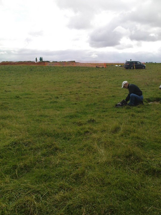
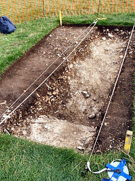
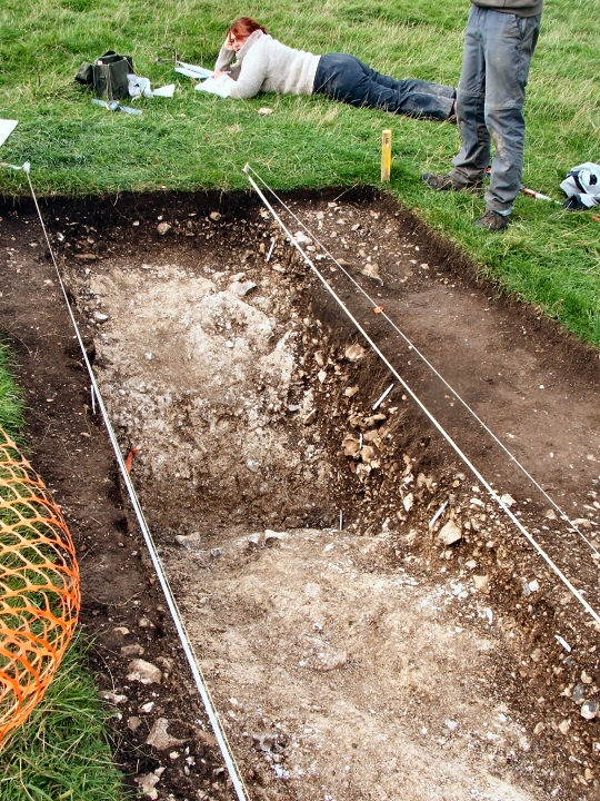
Atkinson found this enigmatic feature in the 1950s.
It seems to lead NNE from the first elbow in the Avenue. Any more information will be welcome. It will be invisible after the excavation.
Comments (0)
|
Add a comment
|
Permalink
Posted by
jimit
7th September 2008ce

 Posted by jimit