The Modern Antiquarian
Log in
|
Register
Home
Latest Posts
Forums
Maps
Help
Browse Sites
News
Blog
Contributors
The Books
Select
-
Belgium
Denmark
Eire
France
Germany
Greece
Italy
The Netherlands
Norway
Portugal
Republic of Malta
Spain
Sweden
Switzerland
United Kingdom
England
Northern England
Cumbria
Ehenside Tarn
Ancient Village / Settlement / Misc. Earthwork
Ehenside Tarn (Ancient Village / Settlement / Misc. Earthwork) on The Modern Antiquarian, the UK & Ireland's most popular megalithic community website. 3 images, plus information on many more ancient sites nearby and across the UK & Ireland.
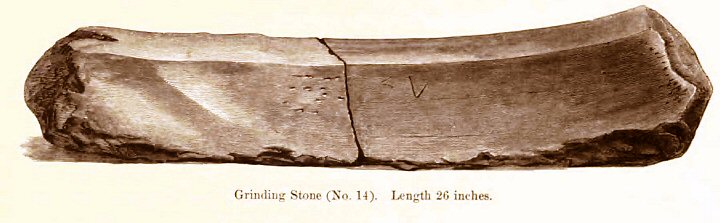
Image © R.D. Derbishire
Nearest Town:
Whitehaven (13km NNW)
OS Ref (GB):
NY006067 /
Sheet: 89
Latitude:
54° 26' 44.59" N
Longitude:
3° 31' 58.94" W
Added by
fitzcoraldo
Images (3)
0 discussions
Start a topic
Show |
Hide
Web searches for Ehenside Tarn
Flickr
Google
Google Images
MAGIC
The Megalithic Portal
Bing
Stone Pages
Streetmap.co.uk
Wikipedia
Show map
(inline Google Map)
- Sites within 20 km -
-
Ringlen Stones (destroyed?) (4.14km NW) (0 posts)
Greycroft Stone Circle (5.2km ESE) (63 posts)
Druids Temple, Yewcroft (5.37km NE) (11 posts)
Gretigate (5.9km E) (5 posts)
Friar Gill Tumulus (6.06km ENE) (4 posts)
Tongue How (6.1km E) (2 posts)
Friar's Well (6.19km ENE) (0 posts)
Tongue How (7.09km ENE) (12 posts)
Tongue How (7.22km ENE) (0 posts)
Town Bank (8.64km ENE) (0 posts)
Blakeley Raise (9.12km NE) (72 posts)
Sampson's Bratfull (9.26km ENE) (15 posts)
Stockdale Moor (9.5km ENE) (17 posts)
Monks Graves (9.52km ENE) (0 posts)
Le Wheles (destroyed?) (11.41km NNW) (0 posts)
Lamplugh (12.46km NNE) (0 posts)
Seatallan (13.36km ENE) (5 posts)
Studfold Gate (15.94km N) (7 posts)
Floutern Cop (16.18km NE) (16 posts)
Barnscar (16.62km ESE) (19 posts)
Low Longrigg (16.99km E) (20 posts)
White Moss (17.09km E) (55 posts)
Brat's Hill (17.21km E) (32 posts)
Boat Howe (17.45km E) (14 posts)
Maiden Castle (Wastwater) (17.78km E) (5 posts)
Whitrow Beck (18.06km ESE) (6 posts)
Dean (19.46km NNE) (3 posts)
Buttermere (19.48km ENE) (5 posts)
Crummock (19.61km NE) (27 posts)
- Facilities within 20 km -
-
Wasdale Head National ... (Camping Site: 17.7 km ENE)
Hollins Farm Campsite (Camping Site: 17.9 km E)
Wasdale Head Inn (Hotel: 18.1 km ENE)
Kirkstile Inn (Pub: 19.6 km NNE)
Syke Farm (Camping Site: 19.7 km NE)
- Add -
-
Add news
Add an image
Add fieldnotes
Add folklore
Add miscellaneous
Add a link
-
Add a site
Add a nearby facility
Add an alternative name/spelling
Images
(click to view fullsize)
Add an image
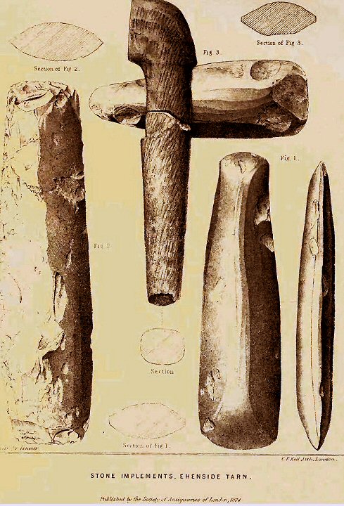
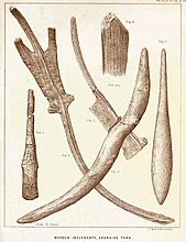 Image © R.D. Derbishire