The Modern Antiquarian
Log in
|
Register
Home
Latest Posts
Forums
Maps
Help
Browse Sites
News
Blog
Contributors
The Books
Select
-
Belgium
Denmark
Eire
France
Germany
Greece
Italy
The Netherlands
Norway
Portugal
Republic of Malta
Spain
Sweden
Switzerland
United Kingdom
County Meath
Balgeeth
Artificial Mound
Balgeeth (Artificial Mound) on The Modern Antiquarian, the UK & Ireland's most popular megalithic community website. 1 image, 1 weblink, plus information on many more ancient sites nearby and across the UK & Ireland.
Image © Knowth.com
Nearest Town:
Carnew (4km W)
OS Ref (IE):
O058626 /
Sheet: 43
Latitude:
53° 36' 9.16" N
Longitude:
6° 24' 5.64" W
Added by
FourWinds
Images (1)
Links (1)
0 discussions
Start a topic
Show |
Hide
Web searches for Balgeeth
Flickr
Google
Google Images
The Megalithic Portal
Bing
Stone Pages
Wikipedia
Show map
(inline Google Map)
- Sites within 20 km -
-
Moorepark (1.31km S) (0 posts)
Boolies Great (2.57km WNW) (0 posts)
Roadmain (2.96km SW) (0 posts)
Piercetown (2.99km SW) (0 posts)
Heathtown Henge I (3.69km ENE) (0 posts)
Heathtown Mound (4.5km ENE) (4 posts)
Heathtown Henge II (4.51km ENE) (5 posts)
Gaulstown (4.63km WNW) (3 posts)
Garristown (4.64km SE) (0 posts)
Micknanstown (4.78km E) (2 posts)
Primatestown (4.87km SSW) (0 posts)
Hilltown Little (5.01km NNE) (0 posts)
Fourknocks (5.1km E) (35 posts)
Bellewstown (5.29km N) (5 posts)
Newtown (5.29km S) (0 posts)
Fourknocks (5.4km E) (5 posts)
Greenanstown (5.64km ENE) (4 posts)
Herbertstown (5.76km ENE) (4 posts)
Windmill Hill (5.98km SW) (0 posts)
Kilbrew (6.34km SW) (3 posts)
Westown North (6.81km E) (1 post)
Mullahteelin (7.03km ENE) (0 posts)
Hodgetown (7.07km E) (0 posts)
Longford (7.86km NW) (0 posts)
Tullog (8.17km ENE) (0 posts)
Mallahow (8.32km ESE) (0 posts)
Damastown (8.33km ESE) (3 posts)
Danestown Ringfort (8.34km W) (4 posts)
Kichenstown (9.96km E) (0 posts)
Knockbrack (10.02km E) (1 post)
Knockbrack (10.09km E) (0 posts)
Newgrange Tumulus B (10.46km NW) (3 posts)
Hollywood Great (10.65km E) (1 post)
Nags Head (10.65km E) (0 posts)
Hedgerow Stone (10.73km NW) (2 posts)
Newgrange Tumulus A (10.8km NW) (3 posts)
Collierstown (10.88km WSW) (0 posts)
Bey More (11.12km NNE) (0 posts)
Newgrange Cursus (11.2km NW) (2 posts)
Dowth Mound III (11.27km NW) (0 posts)
Trevet (11.29km SW) (3 posts)
Newgrange (11.33km NW) (128 posts)
Dowth Mound II (11.33km NW) (0 posts)
The Great Circle (11.34km NW) (23 posts)
Newgrange Standing Stone C (11.34km NW) (6 posts)
Newgrange K & L (11.38km NW) (10 posts)
Dowth II (11.62km NNW) (1 post)
Dowth (11.69km NW) (4 posts)
Dowth I (11.69km NW) (68 posts)
Dowth Mound I (11.72km NNW) (0 posts)
Dowth Henge (11.83km NNW) (10 posts)
Gerrardstown (11.92km W) (0 posts)
Rath Lugh (11.92km WSW) (4 posts)
Rossnaree (12.04km WNW) (3 posts)
Cloghalea (12.1km NNW) (6 posts)
Lismullin (12.3km WSW) (8 posts)
Knowth (12.44km NW) (120 posts)
Realtoge (12.63km W) (4 posts)
Drogheda (12.66km NNE) (0 posts)
Gormanston (12.66km ENE) (6 posts)
Oldbridge (12.89km NNW) (7 posts)
Painestown (12.92km WNW) (0 posts)
Clonardran (12.97km W) (0 posts)
Laytown (An Inse) (12.99km NE) (6 posts)
Blundelstown (13km WSW) (0 posts)
Garlagh (13.05km W) (0 posts)
Gormanston Beach (13.07km ENE) (3 posts)
Cabragh (13.21km WSW) (0 posts)
Johnstown (13.33km WNW) (0 posts)
Littlegrange (13.54km NNW) (9 posts)
Monknewtown Pond (13.77km NW) (4 posts)
Monknewtown II (13.81km NW) (3 posts)
Townley Hall Barrow (13.84km NNW) (0 posts)
Townley Hall Souterrain (13.86km NNW) (0 posts)
Monknewtown (13.88km NW) (2 posts)
Churchyard Stones (13.95km WSW) (12 posts)
The Banqueting Hall (13.99km WSW) (10 posts)
Inch (14km E) (0 posts)
Rath Maeve (14.11km WSW) (10 posts)
Rath of Synods (14.14km WSW) (7 posts)
The Barrows (14.14km WSW) (0 posts)
Bremore (14.16km ENE) (36 posts)
The Mound of Hostages (14.16km WSW) (28 posts)
Lia Fail (14.16km WSW) (23 posts)
The King's Seat (14.16km WSW) (12 posts)
Cormac's House (14.16km WSW) (9 posts)
The Royal Enclosure (14.16km WSW) (2 posts)
Grainne's Enclosure (14.17km WSW) (6 posts)
The Sloping Trenches (14.17km WSW) (3 posts)
Rath Laoghaire (14.19km WSW) (2 posts)
Balrothery (14.5km E) (7 posts)
Skidoo (14.61km ESE) (0 posts)
Gallows Hill (14.65km WNW) (0 posts)
Kingstown & Carnuff Great (14.71km W) (1 post)
Stanley Hill (14.8km WNW) (0 posts)
Hill of Slane Souterrain (15.4km WNW) (0 posts)
Hill of Slane Barrow (15.84km WNW) (1 post)
Dunsany (15.91km WSW) (4 posts)
Mellifont (16.04km NW) (0 posts)
Knockmark (16.25km SW) (0 posts)
Baltray (16.61km NE) (12 posts)
Grange (16.96km E) (11 posts)
Mooretown (16.97km SW) (0 posts)
Barnageeragh (17.1km E) (2 posts)
Lusk (17.38km E) (2 posts)
Balcunnin (17.49km E) (3 posts)
Ho Stone, Balcunnin (17.55km E) (2 posts)
Rathmaiden (17.57km WNW) (0 posts)
Ardsallagh (17.69km W) (2 posts)
Gernonstown (17.7km WNW) (2 posts)
Culmullin (17.91km SW) (4 posts)
Gernonstown (18.34km WNW) (5 posts)
Lismahon (18.51km SW) (1 post)
Fieldstown (18.72km N) (7 posts)
Stackallan (19.26km WNW) (2 posts)
Davidstown Barrow (19.29km WNW) (0 posts)
Termonfeckin (19.31km NNE) (0 posts)
Kilbride (Talbotstown Lower By.) (19.41km NNW) (6 posts)
Cooljohn (19.46km WSW) (2 posts)
Milltown (19.65km NNE) (0 posts)
- Add -
-
Add news
Add an image
Add fieldnotes
Add folklore
Add miscellaneous
Add a link
-
Add a site
Add a nearby facility
Add an alternative name/spelling
Images
(click to view fullsize)
Add an image
Links
Add a link
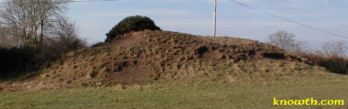
Mound at Balgeeth, Ardcath, Co. Meath, Ireland.
The oval mound at Balgeeth, Ardcath has not been excavated. The mound measures 12 metres north-south and 9 metres east-west. The mound is situated on a ridge between Newgrange to the North and Fourknocks to the East.
Comments (0)
|
Add a comment
|
Permalink
Posted by
knowth
8th June 2003ce

 Posted by knowth