The Modern Antiquarian
Log in
|
Register
Home
Latest Posts
Forums
Maps
Help
Browse Sites
News
Blog
Contributors
The Books
Select
-
Belgium
Denmark
Eire
France
Germany
Greece
Italy
The Netherlands
Norway
Portugal
Republic of Malta
Spain
Sweden
Switzerland
United Kingdom
County Limerick
Tynacocka
Standing Stone / Menhir
Tynacocka (Standing Stone / Menhir) on The Modern Antiquarian, the UK & Ireland's most popular megalithic community website. 1 image, 1 fieldnote, plus information on many more ancient sites nearby and across the UK & Ireland.
Image © Bawn79 © 2008
Nearest Town:
Bruff (2km N)
OS Ref (IE):
R623345 /
Sheet: 65
Latitude:
52° 27' 38.74" N
Longitude:
8° 33' 16.95" W
Added by
bawn79
Images (1)
Fieldnotes (1)
0 discussions
Start a topic
Show |
Hide
Web searches for Tynacocka
Flickr
Google
Google Images
The Megalithic Portal
Bing
Stone Pages
Wikipedia
Show map
(inline Google Map)
- Sites within 20 km -
-
Bruff (1.45km NNE) (3 posts)
Knocktwo (3.62km WSW) (3 posts)
Grillagh (3.79km NE) (0 posts)
Bulgadenhall (4.13km ESE) (1 post)
Cnoc Aine (4.82km ENE) (2 posts)
Cnoc Aine (4.89km ENE) (1 post)
Ballinculloo (4.94km WSW) (4 posts)
Cnoc Aine (5.05km ENE) (3 posts)
Rockbarton (5.42km NNW) (3 posts)
Black Sow’s Bed (5.53km NNE) (6 posts)
Cnoc Aine (5.65km ENE) (7 posts)
Cnoc Aine (5.74km ENE) (6 posts)
The Stone Of The Tree (5.98km N) (6 posts)
Grange Lios (6.06km N) (9 posts)
Ballinscaula (6.21km ESE) (2 posts)
Ballinscaula (6.21km ESE) (6 posts)
The Pillar Stone (6.39km N) (8 posts)
Gorteennacreeagh (6.41km ENE) (2 posts)
Knockadoon Circles A + B (6.44km NNE) (1 post)
Knockadoon Circle K (6.5km NNE) (5 posts)
Old Hags Chair (6.6km NNE) (2 posts)
Knockadoon (6.66km NNE) (1 post)
Loughgur (6.7km NNE) (0 posts)
Grange / Lios, Lough Gur (6.71km NNE) (87 posts)
Lough Gur Wedge Tomb (6.71km NNE) (26 posts)
Lough Gur C (6.81km N) (17 posts)
Lough Gur D (6.81km N) (6 posts)
Knockfennel (6.83km N) (4 posts)
Knockfennel (6.86km N) (2 posts)
Carraig Aille (6.97km NNE) (4 posts)
Carraig Aille (6.97km NNE) (7 posts)
Entrance to Tir Na Og (7.04km NNE) (3 posts)
Rathanny (7.07km E) (7 posts)
Cloghaunainey (7.16km ENE) (1 post)
Ballinvana (7.19km E) (2 posts)
Knockfennel North (7.29km N) (4 posts)
Lough Gur P (7.34km NNE) (1 post)
Knockfennel (7.37km NNE) (3 posts)
Lough Gur O (7.38km NNE) (8 posts)
Elton (7.45km E) (6 posts)
Moohane (7.95km NE) (4 posts)
Castlefarm (8km ENE) (4 posts)
Gotoon (8.08km ENE) (2 posts)
Ballynamona (8.21km ENE) (4 posts)
Knockroe (8.3km NE) (3 posts)
Rathmore South (8.34km WNW) (3 posts)
Ballingoola A (8.45km N) (2 posts)
Coolalough (8.47km ENE) (2 posts)
Ballingoola B (8.52km N) (1 post)
Knocksouna (8.68km SW) (1 post)
Ballingoola C (8.72km N) (1 post)
Ballingoola (8.74km N) (1 post)
Ballingoola D (9.01km N) (0 posts)
Coolalough (9.05km ENE) (2 posts)
Ballingoola E (9.21km N) (1 post)
Lodge (9.46km ENE) (4 posts)
Hospital (9.67km ENE) (2 posts)
Rootiagh (9.74km NE) (3 posts)
Rootiagh (9.95km NE) (1 post)
Coolalough (10km ENE) (5 posts)
Cromwell Hill (11.53km ENE) (7 posts)
Cush (11.53km ESE) (5 posts)
Carrignacaubeen (11.79km ESE) (2 posts)
Clogher Hill (11.85km E) (2 posts)
Cush (12km ESE) (1 post)
Kilfinnane (12.16km SE) (4 posts)
Tory Hill (12.21km WNW) (2 posts)
Ballybricken West (12.3km N) (3 posts)
Ballyriggin (12.59km ESE) (2 posts)
Ballygeagoge (12.64km SE) (1 post)
Ballyriggin (12.7km ESE) (3 posts)
Ballybricken East (12.79km N) (2 posts)
Ballygeagoge (12.82km SE) (0 posts)
Ballybricken East (12.96km N) (3 posts)
Ballybricken East (13.01km NNE) (4 posts)
Kilfinnane (13.08km SE) (2 posts)
Stonepark (13.24km N) (2 posts)
Ballygeagoge (13.26km SE) (1 post)
Luddenmore (13.35km N) (5 posts)
Luddenmore (13.35km N) (3 posts)
Mortlestown Hill (13.36km SE) (5 posts)
Knockroe (13.42km ENE) (1 post)
Brufea (13.44km N) (3 posts)
Knockroe (13.56km N) (2 posts)
Knockroe (13.68km N) (2 posts)
Knockroe (13.73km NNE) (7 posts)
Cloghast (13.76km ESE) (5 posts)
Ardpatrick (13.76km SSE) (5 posts)
Cloonyconry More (13.9km ENE) (4 posts)
Ballinlyna Lower (13.94km SE) (1 post)
Ladys Well (13.95km SE) (3 posts)
Carraigapuckaun (14.24km ESE) (2 posts)
Ballyfroota (14.31km E) (3 posts)
Inch (14.34km N) (5 posts)
Bawnacouma (14.4km NW) (1 post)
Inch St. Lawrence (14.72km N) (7 posts)
Ballingarry (14.76km ESE) (1 post)
Longstone (14.83km NE) (2 posts)
Friarstown (14.97km NW) (6 posts)
Ballingarry (15.29km E) (3 posts)
Mountrussel (15.89km S) (2 posts)
Lissard (15.9km E) (3 posts)
Lissard (15.94km E) (10 posts)
Skahard (15.95km N) (3 posts)
Highpark (16.19km N) (4 posts)
Highpark (16.24km N) (3 posts)
Cnoc Greine (16.34km NE) (3 posts)
Highpark (16.38km N) (1 post)
Highpark (16.41km N) (2 posts)
Castletown (16.66km WSW) (4 posts)
Duntryleague Cairn (16.69km E) (1 post)
Duntryleague (16.69km E) (32 posts)
Knocsefin (16.71km NE) (3 posts)
Sarsfields Rock (16.84km ENE) (3 posts)
Seefin Hill (16.86km SSE) (5 posts)
Knockfeerina (16.94km W) (7 posts)
Buachaill Bréige (17.12km W) (7 posts)
Knockfeerina (17.12km W) (11 posts)
Glenbane (17.18km ENE) (1 post)
Knockeen (17.38km NNE) (1 post)
Darragh Graveyard (17.5km SE) (3 posts)
Knocksefin (17.89km NE) (1 post)
Longstone (17.96km ENE) (3 posts)
Longstone (17.96km ENE) (1 post)
Longstone (17.96km ENE) (8 posts)
Liseen (18.52km NE) (3 posts)
Adare Manor (18.78km WNW) (8 posts)
Lattin (18.83km ENE) (3 posts)
Caherclogh (19.15km WSW) (2 posts)
Lattin (19.34km ENE) (3 posts)
- Add -
-
Add news
Add an image
Add fieldnotes
Add folklore
Add miscellaneous
Add a link
-
Add a site
Add a nearby facility
Add an alternative name/spelling
Images
(click to view fullsize)
Add an image
Fieldnotes
Add fieldnotes
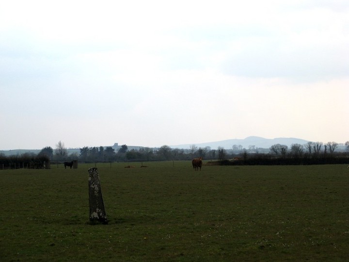
This standing stone is about a mile south of Bruff. The stone is one of those thin ones that seem to be around this part of limerick and is about 1.2m high.
In the picture you can see Knockfeerina in the background.
Comments (0)
|
Add a comment
|
Permalink
Posted by
bawn79
23rd April 2008ce