The Modern Antiquarian
Log in
|
Register
Home
Latest Posts
Forums
Maps
Help
Browse Sites
News
Blog
Contributors
The Books
Select
-
Belgium
Denmark
Eire
France
Germany
Greece
Italy
The Netherlands
Norway
Portugal
Republic of Malta
Spain
Sweden
Switzerland
United Kingdom
Scotland
Perth and Kinross
Tomintianda
Cup Marked Stone
Tomintianda (Cup Marked Stone) on The Modern Antiquarian, the UK & Ireland's most popular megalithic community website. 3 images, 1 fieldnote, plus information on many more ancient sites nearby and across the UK & Ireland.
Image © tiompan
Nearest Town:
Pitlochry (13km E)
OS Ref (GB):
NN817606 /
Sheet: 43
Latitude:
56° 43' 19.35" N
Longitude:
3° 56' 0.02" W
Added by
tiompan
Images (3)
Fieldnotes (1)
0 discussions
Start a topic
Show |
Hide
Web searches for Tomintianda
Flickr
Google
Google Images
MAGIC
The Megalithic Portal
Bing
Stone Pages
Streetmap.co.uk
Wikipedia
Show map
(inline Google Map)
- Sites within 20 km -
-
Lurgan (0.28km ESE) (42 posts)
Balnabodach (0.8km E) (11 posts)
Na Carraigean (2.6km ENE) (40 posts)
Queen's View (4.61km E) (5 posts)
Clach Na h-Iobairt (5.31km N) (14 posts)
Kinaldie (5.4km W) (1 post)
Tombreck (5.5km SW) (1 post)
Tombreck (5.66km SW) (0 posts)
Tulach Hill (5.66km NE) (7 posts)
Fincastle Farm (6.09km ENE) (5 posts)
Dundavie (6.32km ENE) (3 posts)
Creag Odhar (6.74km ENE) (4 posts)
Upper Gaskan (6.99km W) (27 posts)
Clach na h' Iobairt (7.52km NE) (9 posts)
Craig Kynachan (7.54km WSW) (4 posts)
Strathgarry (7.56km ENE) (6 posts)
Over Bohespic (7.59km W) (6 posts)
Ardtulichan (7.79km ENE) (6 posts)
Braes of Foss (8.36km SW) (24 posts)
Ardtulichan (8.39km ENE) (3 posts)
Ardtulichan (8.47km ENE) (3 posts)
Sithean Na Cluana (9.23km ENE) (0 posts)
Strathgroy (9.28km ENE) (7 posts)
Killiecrankie (9.43km ENE) (17 posts)
Boltachan Burn (9.47km SE) (0 posts)
Glassie (9.93km SE) (8 posts)
Lettoch (10.03km ENE) (7 posts)
Pitcastle (10.07km ESE) (3 posts)
Creagan Fheadaire (10.07km ESE) (4 posts)
Lurgan Farm (10.09km ESE) (6 posts)
Glen Clune (10.18km ENE) (5 posts)
Middleton of Derculich (10.61km ESE) (6 posts)
Tullochroisk (10.78km WSW) (2 posts)
Balendune (10.79km ESE) (7 posts)
Glen Clune (10.84km ENE) (3 posts)
Glengoulandie (10.97km SSW) (21 posts)
Tom-an-Droighne (11.12km ESE) (0 posts)
Old Faskally (11.16km ENE) (4 posts)
Balhomais (11.2km SSE) (17 posts)
Old Faskally (11.26km ENE) (4 posts)
Craigiedun (11.31km E) (8 posts)
Garth Cottage (11.35km SSW) (1 post)
Castle Menzies Cursus (11.35km SSE) (1 post)
Nether Tullicro (11.39km S) (0 posts)
The Appin of Dull (11.45km S) (12 posts)
Garth Estate III (11.47km SSW) (1 post)
Faskally - Pitlochry (11.48km E) (34 posts)
Garth Lodge (11.55km SW) (4 posts)
Garth Lodge (11.55km SW) (1 post)
Carn Tulach (11.57km ESE) (8 posts)
Glen Fender (11.59km ENE) (5 posts)
Clachan An Diridh (11.69km E) (65 posts)
Tullypowrie (11.8km E) (8 posts)
Clach Na Buidseach (11.8km E) (3 posts)
Garth Bothy (11.89km SSW) (1 post)
Lundin Farm (11.9km ESE) (43 posts)
Carse Farm I (11.97km S) (26 posts)
Lundin (11.99km ESE) (5 posts)
Wester Litigan (12.23km SSW) (1 post)
Carse Farm II (12.27km S) (11 posts)
Dane's Stone (12.51km E) (27 posts)
Cnoc Dubh (12.6km E) (2 posts)
Haugh of Grandtully Farm (12.64km E) (15 posts)
Baledmond (12.75km ENE) (7 posts)
Balnakeilly Stone (12.91km E) (19 posts)
East Tempar (12.93km WSW) (6 posts)
Comrie Bridge (12.98km S) (7 posts)
Tullichuil (13.21km S) (4 posts)
Pitnacree (13.24km E) (22 posts)
Knoc-Na-Eaglais (13.39km ESE) (2 posts)
Croft Moraig (13.42km S) (75 posts)
Dunfallandy (13.44km E) (6 posts)
An Torr (13.68km SE) (11 posts)
Drumcharry (13.69km SSW) (11 posts)
Grantully Hill (13.77km ESE) (2 posts)
Newhall Bridge Two Poster (14.08km S) (31 posts)
Remain Rock (14.16km S) (5 posts)
Urlar Burn (14.31km SE) (2 posts)
Coilleaichur (14.54km SE) (5 posts)
Balnakeilly (14.63km E) (10 posts)
Black Burn (14.63km SSE) (46 posts)
Finduie Wood (14.9km SW) (7 posts)
Clach na Boile (14.99km WSW) (9 posts)
Clach Na Croiche (15.4km E) (24 posts)
Fortingall (15.44km SSW) (44 posts)
Fortingall Churchyard (15.54km SSW) (15 posts)
Craig Hill (15.57km SSE) (59 posts)
Carn na Marbh (15.63km SSW) (8 posts)
Braes of Balloch (15.64km S) (8 posts)
Kenmore Church (15.73km SSW) (2 posts)
Tombuie Cottage (16.04km S) (4 posts)
Braes of Taymouth (16.13km S) (4 posts)
Clach a' Mharsainte (16.33km WSW) (11 posts)
Bridge of Lyon Cairn (16.34km SW) (18 posts)
Bridge of Lyon Standing Stones (16.56km SW) (21 posts)
Coille Dhubh (16.58km SW) (2 posts)
Bridge of Lyon (16.58km SW) (10 posts)
Cuigeal-Mairi (16.64km SSW) (1 post)
Clach Ghlas (16.71km WSW) (4 posts)
Badyo (16.79km ENE) (6 posts)
Balmacnaughton (17.53km SSW) (10 posts)
Tigh Na Ruaich (17.58km E) (33 posts)
Cromrar (18km SW) (8 posts)
Craigbea (18.02km E) (3 posts)
Croftmartaig (18.11km SSW) (1 post)
Clach an Tuirc (18.22km SW) (4 posts)
Acharn Burn (18.53km SSW) (8 posts)
Clach-na-Cruich (18.62km SW) (3 posts)
Falls of Acharn Stone Circle (18.74km SSW) (55 posts)
Oakbank Crannog (18.77km SSW) (4 posts)
Remony Burn (19.05km S) (13 posts)
Clach Glas (19.24km E) (8 posts)
Dalnavaid (19.36km ENE) (4 posts)
Shian Burn (19.38km SSE) (0 posts)
Shian Burn (19.47km SSE) (3 posts)
Haugh Cottages (19.5km E) (2 posts)
Tulliemet (19.91km E) (2 posts)
Creag Na Larach (19.96km E) (4 posts)
Clach na h' Iobairte (19.99km WSW) (15 posts)
- Facilities within 20 km -
-
Loch Tummel Inn (Pub: 0.4 km SSE)
Struan Inn (Hotel: 4.9 km NNW)
House of Bruar (Restaurant: 5.3 km N)
Faskally Caravan Park (Camping Site: 10.2 km E)
House of Menzies (Cafe: 11.1 km SSE)
Black Watch Inn (Pub: 12.1 km SSE)
Breadalbane Arms Hotel (Pub: 12.2 km SSE)
Pitlochry Backpackers ... (Youth Hostel: 12.3 km E)
The Moulin Inn (Hotel: 12.8 km E)
Fortingall Hotel (Hotel: 13.7 km SSW)
Kenmore Hotel (Hotel: 15.7 km S)
- Add -
-
Add news
Add an image
Add fieldnotes
Add folklore
Add miscellaneous
Add a link
-
Add a site
Add a nearby facility
Add an alternative name/spelling
Images
(click to view fullsize)
Add an image
Fieldnotes
Add fieldnotes
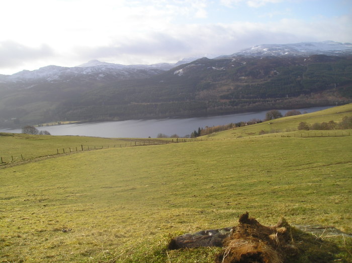
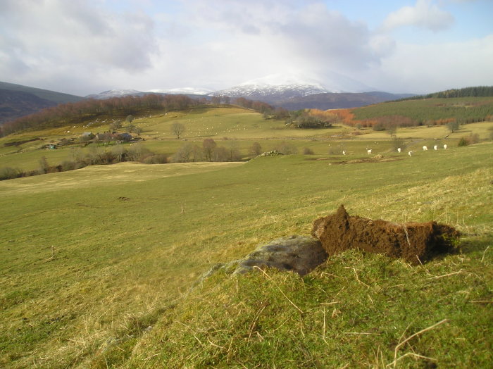
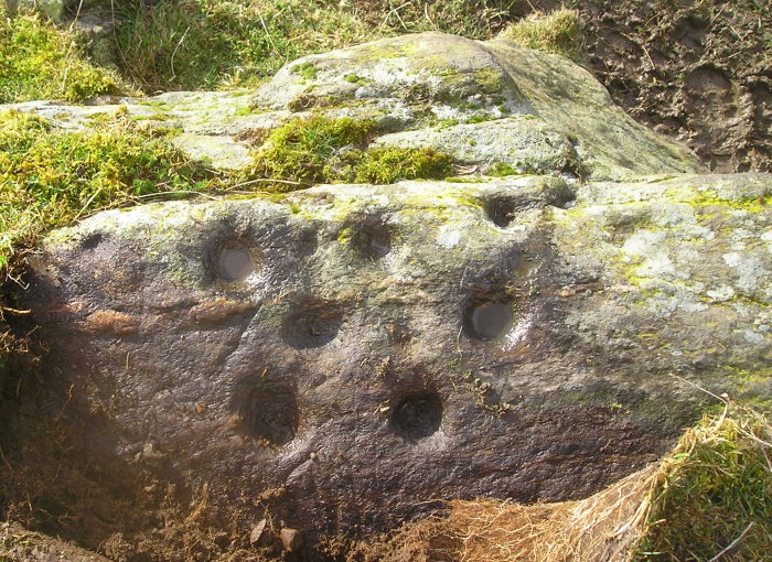
Found a couple of weeks ago , previously unrecorded .The site is on the northern side of Loch Tummel . It is approx a mile west of the more ornate Craig Balnabodach .The most obvious hills in view are Schiehallion and Farragon .
Comments (1)
|
Add a comment
|
Permalink
Posted by
tiompan
10th April 2008ce

 Posted by tiompan