The Modern Antiquarian
Log in
|
Register
Home
Latest Posts
Forums
Maps
Help
Browse Sites
News
Blog
Contributors
The Books
Select
-
Belgium
Denmark
Eire
France
Germany
Greece
Italy
The Netherlands
Norway
Portugal
Republic of Malta
Spain
Sweden
Switzerland
United Kingdom
County Kildare
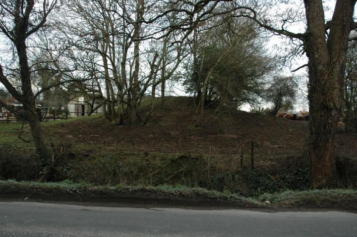
Firmount East
Artificial Mound
Firmount East (Artificial Mound) on The Modern Antiquarian, the UK & Ireland's most popular megalithic community website. 1 image, plus information on many more ancient sites nearby and across the UK & Ireland.
Image © ryaner
Nearest Town:
Kill (8km ESE)
OS Ref (IE):
N864265 /
Sheet: 49
Latitude:
53° 16' 54.46" N
Longitude:
6° 42' 16.11" W
Added by
ryaner
Images (1)
0 discussions
Start a topic
Show |
Hide
Web searches for Firmount East
Flickr
Google
Google Images
The Megalithic Portal
Bing
Stone Pages
Wikipedia
Show map
(inline Google Map)
- Sites within 20 km -
-
Clane (1.61km ENE) (4 posts)
Barretstown Hill (3.08km SSE) (1 post)
Maudlings (7.26km ESE) (4 posts)
Forenaghts Great (9.36km ESE) (8 posts)
Forenachts (9.38km ESE) (3 posts)
Baltracy (10.7km ESE) (1 post)
Craddockstown West (11.25km SE) (9 posts)
Punchestown Standing Stone (11.29km SE) (15 posts)
Punchestown (11.6km SE) (6 posts)
Griffinrath (11.66km NE) (2 posts)
Hill of Allen (12.05km WSW) (7 posts)
Ringwood (12.76km ENE) (4 posts)
Athgoe Hill (12.87km ENE) (6 posts)
Kilteel (13.25km E) (2 posts)
Newtown lower (13.32km E) (7 posts)
Grange (Newcastle By.) (13.35km ENE) (3 posts)
Cromwellstown (13.49km E) (2 posts)
Newtown Park (13.77km ESE) (4 posts)
Killickaweeny (13.96km NNW) (1 post)
The Ring (14.16km SE) (0 posts)
Caureen (14.52km ESE) (7 posts)
Newtown Great (14.6km ESE) (0 posts)
Knockandinny (15.59km E) (0 posts)
Curragh (15.63km SSW) (1 post)
Slievethoul I (15.68km E) (9 posts)
Crockaunadreenagh (15.69km E) (7 posts)
Slievethoul II and III (15.69km E) (4 posts)
Slievethoul II (15.87km E) (0 posts)
Tinode II (16.05km E) (2 posts)
Rathcoole (16.24km E) (6 posts)
Little Curragh Barrow VII (16.3km SW) (1 post)
Curragh Racecourse (16.3km SW) (1 post)
Tinode (16.32km E) (3 posts)
Little Curragh Barrow VI (16.51km SW) (5 posts)
Curragh (Kildare ED) (16.59km SW) (7 posts)
Little Curragh Barrow V (16.65km SW) (6 posts)
Little Curragh Barrow VIII (16.68km SW) (1 post)
Blessington Demesne 2 (16.71km ESE) (4 posts)
Blessington Demesne 1 (16.71km ESE) (18 posts)
Lugg (16.84km E) (13 posts)
Lugg (16.93km E) (1 post)
Chair of Kildare (16.98km WSW) (5 posts)
Curragh Racecourse (17.01km SW) (1 post)
Little Curragh Barrow IV (17.08km SW) (4 posts)
Ticknevin (17.17km W) (2 posts)
Little Curragh Barrow III (17.21km SW) (5 posts)
Glenaraneen (17.23km E) (7 posts)
Little Curragh Barrow I (17.42km SW) (7 posts)
Little Curragh Barrow II (17.42km SW) (3 posts)
Crooksling (17.42km E) (0 posts)
Curragh (Kildare ED) II (17.46km SW) (4 posts)
Little Curragh VIX (17.52km SW) (1 post)
Raheen (17.61km E) (5 posts)
Goldenhill mound (17.61km E) (2 posts)
Goldenhill (17.61km E) (13 posts)
Curragh (Kildare ED) I (17.66km SW) (1 post)
Gibbet Rath (17.71km SW) (7 posts)
Little Curragh X (17.79km SW) (1 post)
Boherboy (17.84km E) (19 posts)
Ballymore Eustace West (18.03km SE) (5 posts)
Curragh (Kildare ED) (18.06km SW) (2 posts)
Curragh (18.09km SSW) (1 post)
Knockiernan (18.12km ESE) (0 posts)
Mountseskin (18.33km E) (1 post)
Carignagower (18.37km E) (0 posts)
Butterhill (18.4km ESE) (0 posts)
Crooksling (18.43km E) (9 posts)
Bishopsland (18.5km SE) (3 posts)
Butterhill (18.56km ESE) (0 posts)
Lucan and Pettycannon (18.76km ENE) (3 posts)
Trinity Well (18.81km W) (2 posts)
Dowery (18.86km E) (0 posts)
Kilbride (Talbotstown Lower By.) (18.86km E) (2 posts)
Longstone (18.97km SE) (0 posts)
Kilbride (Talbotstown Lower By.) (18.99km E) (4 posts)
Kilbride (Talbotstown Lower By.) (18.99km E) (2 posts)
Carrig Standing Stone (19.05km ESE) (2 posts)
Ballybought (19.2km SSE) (3 posts)
Kildare (19.25km SW) (3 posts)
Carrig Wedge Tomb (19.28km ESE) (11 posts)
Knockatillane (19.34km E) (2 posts)
Blackrock (19.35km ESE) (4 posts)
Carrig Cairns (19.48km ESE) (7 posts)
Carrig Rath (19.48km ESE) (0 posts)
Lugmore (19.5km E) (0 posts)
Lugmore Cist (19.5km E) (7 posts)
Ballyfolan (19.51km E) (4 posts)
Knockannavea (19.55km E) (3 posts)
Ballyfolan (19.58km E) (10 posts)
Carbury Hill (19.66km W) (27 posts)
Sroughan (19.71km ESE) (6 posts)
Ballybought (19.74km SSE) (5 posts)
Butter Mountain (19.76km E) (3 posts)
Old Kilcullen (19.76km S) (1 post)
Woodend Hill (19.82km ESE) (0 posts)
Oldcourt (19.84km ESE) (4 posts)
Sroughan (19.86km ESE) (1 post)
Red Hill (19.92km SW) (5 posts)
Dun Ailinne (19.96km S) (5 posts)
Lugnagun Cairn (19.97km ESE) (4 posts)
- Add -
-
Add news
Add an image
Add fieldnotes
Add folklore
Add miscellaneous
Add a link
-
Add a site
Add a nearby facility
Add an alternative name/spelling
Images
(click to view fullsize)
Add an image
 Image © ryaner