The Modern Antiquarian
Log in
|
Register
Home
Latest Posts
Forums
Maps
Help
Browse Sites
News
Blog
Contributors
The Books
Select
-
Belgium
Denmark
Eire
France
Germany
Greece
Italy
The Netherlands
Norway
Portugal
Republic of Malta
Spain
Sweden
Switzerland
United Kingdom
County Kerry
Ballynahow Beg
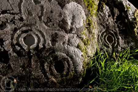
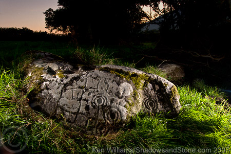
Cup and Ring Marks / Rock Art
Ballynahow Beg (Cup and Ring Marks / Rock Art) on The Modern Antiquarian, the UK & Ireland's most popular megalithic community website. 3 images, plus information on many more ancient sites nearby and across the UK & Ireland.
Image © Ken Williams/ShadowsandStone.com 2007
Nearest Town:
Cahershiveen (7km SW)
OS Ref (IE):
V531821 /
Sheet: 83
Latitude:
51° 58' 18.12" N
Longitude:
10° 8' 16.61" W
Added by
CianMcLiam
Images (3)
1 discussion topic
Start a topic
Show |
Hide
Web searches for Ballynahow Beg
Flickr
Google
Google Images
The Megalithic Portal
Bing
Stone Pages
Wikipedia
Show map
(inline Google Map)
- Sites within 20 km -
-
Kilcaskan (1.17km WSW) (1 post)
Toon (3.87km ENE) (6 posts)
Caherlehillan (4.43km ENE) (2 posts)
Caherlehillan South (4.65km ENE) (4 posts)
Caherlehillan North (4.86km ENE) (3 posts)
Gortnagulla (4.86km ENE) (3 posts)
Keeltrasna (5.09km W) (3 posts)
Cahersiveen (7.06km WSW) (3 posts)
Cahergal (8.4km WSW) (8 posts)
Leacanabuile (8.66km WSW) (6 posts)
Oghermong (9.31km SW) (1 post)
Kealduff (331) (10.26km ENE) (4 posts)
Kealduff (337) (10.35km ENE) (1 post)
Kealduff (334) (10.35km ENE) (1 post)
Kealduff (333) (10.39km ENE) (1 post)
Coomasaharn (10.53km ENE) (3 posts)
Coolnaharagill Upper (11.42km NE) (2 posts)
Dromod (12.94km SSE) (3 posts)
Glanleam (13.39km WSW) (2 posts)
Waterville (16.45km S) (3 posts)
Cool East (16.71km WSW) (6 posts)
Cool (16.96km WSW) (5 posts)
Doonmanagh (Puicin an Chairn) (17.29km NNW) (12 posts)
Kinard East (17.41km NNW) (2 posts)
Eightercua (17.48km S) (22 posts)
Minard (17.56km NNW) (4 posts)
Aghacaribble 1 (17.59km NNW) (8 posts)
Ardamore (17.89km NNW) (14 posts)
Ardamore (17.89km NNW) (5 posts)
Dromtine (18.06km ESE) (4 posts)
Lugnagappul (18.21km N) (3 posts)
Graigue (18.27km NNW) (11 posts)
Foheraghmore (18.3km NNW) (4 posts)
Gallaunmore (19.49km NW) (2 posts)
- Add -
-
Add news
Add an image
Add fieldnotes
Add folklore
Add miscellaneous
Add a link
-
Add a site
Add a nearby facility
Add an alternative name/spelling
Images
(click to view fullsize)
Add an image