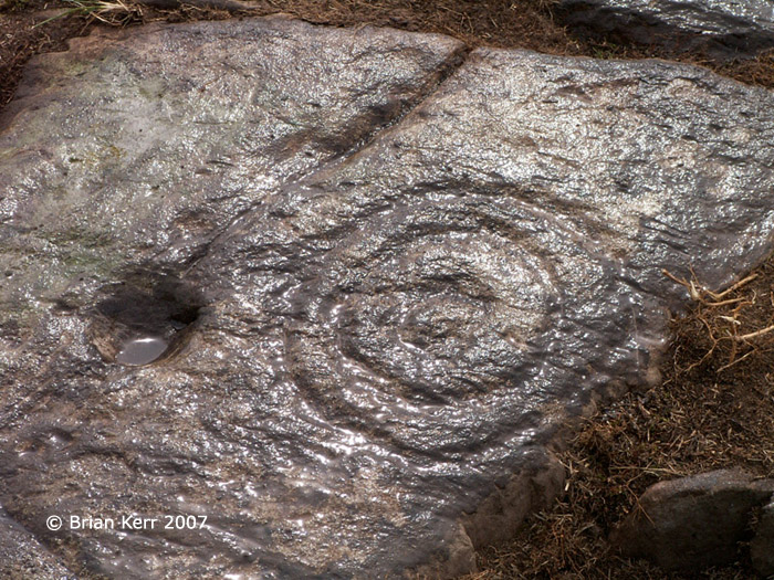
The Modern Antiquarian
Log in
|
Register
Home
Latest Posts
Forums
Maps
Help
Browse Sites
News
Blog
Contributors
The Books
Select
-
Belgium
Denmark
Eire
France
Germany
Greece
Italy
The Netherlands
Norway
Portugal
Republic of Malta
Spain
Sweden
Switzerland
United Kingdom
Scotland
Dumfries and Galloway
Boyach
Cup and Ring Marks / Rock Art
Boyach (Cup and Ring Marks / Rock Art) on The Modern Antiquarian, the UK & Ireland's most popular megalithic community website. 1 image, 2 weblinks, plus information on many more ancient sites nearby and across the UK & Ireland.
Image © © Brian Kerr 2007
Nearest Town:
Whithorn (6km NW)
OS Ref (GB):
NX471364 /
Sheet: 83
Latitude:
54° 41' 56.93" N
Longitude:
4° 22' 22.71" W
Added by
rockartwolf
Images (1)
Links (2)
0 discussions
Start a topic
Show |
Hide
Web searches for Boyach
Flickr
Google
Google Images
MAGIC
The Megalithic Portal
Bing
Stone Pages
Streetmap.co.uk
Wikipedia
Show map
(inline Google Map)
- Sites within 20 km -
-
Isle Head (0.99km E) (0 posts)
Steinhead Mote (1.63km ENE) (4 posts)
Burrow Head (2.73km SW) (1 post)
Little Balsmith (3.42km NNW) (5 posts)
Whithorn (4.65km WNW) (2 posts)
Rispain Camp (5.45km WNW) (7 posts)
Gallows Outon 2 (5.88km NW) (4 posts)
Gallows Outon 1 (6.13km NW) (4 posts)
Glasserton Mains (6.47km W) (19 posts)
Broughton Mains (9.28km NNW) (21 posts)
Blairbuy 2 (10.87km W) (5 posts)
Blairbuy 5 (10.89km W) (4 posts)
Blairbuy - 10 (11.01km W) (3 posts)
Blairbuy 1 (11.05km W) (8 posts)
Knock (11.19km W) (41 posts)
St Medana's Well (11.22km W) (5 posts)
Blairbuy 3 (11.23km W) (6 posts)
Blairbuy 4 (11.68km W) (5 posts)
Culnoag (11.78km NW) (7 posts)
Penkiln (11.81km N) (32 posts)
Blairbuy 6 (11.97km W) (9 posts)
Blairbuy Farm (12.03km W) (1 post)
Blairbuy Standing Stones (12.03km W) (10 posts)
Culscadden (12.08km NNW) (8 posts)
Big Balcraig (12.24km WNW) (7 posts)
Fell of Barhullion (12.26km W) (6 posts)
The Wren's Egg & Nest (12.26km W) (45 posts)
Claunch (12.57km NW) (15 posts)
White Loch of Myrton (13.15km W) (8 posts)
Drumtroddan Standing Stones (13.22km W) (37 posts)
Barsalloch Point (13.23km W) (9 posts)
Drumtroddan Carved Rocks (13.58km W) (48 posts)
Culgarie (14.66km WNW) (12 posts)
North Balfern HillFort (14.96km NW) (2 posts)
North Balfern (15.03km NW) (6 posts)
Mossyard (16.69km NNE) (21 posts)
Mossyard 1 (16.72km NNE) (9 posts)
Castle Haven (17.01km NE) (6 posts)
Kirkclaugh (17.06km NNE) (1 post)
Mossyard 6 (17.14km NNE) (7 posts)
Kirkclaugh (17.28km NNE) (2 posts)
Barholm 2 (17.31km NNE) (1 post)
Kirkdale House (17.43km N) (2 posts)
Barholm 1 (17.43km N) (1 post)
Newton Farm (17.76km NNE) (3 posts)
Tongue Croft (17.79km NE) (18 posts)
Kirkdale Mains Stone (17.85km N) (1 post)
Bardristane 1 (17.87km NNE) (5 posts)
Newton Farm Burial Chamber (17.94km NNE) (12 posts)
Bardristane 4 (18.02km NNE) (6 posts)
Kirkmuir (18.04km N) (3 posts)
Bardristane 3 (18.06km NNE) (3 posts)
Kirkmuir 1a & 1b (18.09km N) (1 post)
Kirkmuir 2 (18.09km N) (1 post)
Cairnholy 01 & 02 (18.09km N) (8 posts)
Cairnholy (18.09km N) (138 posts)
Laggan Farm (18.18km NNE) (3 posts)
Kirkmuir 3 (18.18km N) (1 post)
Doon of Carsluith (18.21km N) (8 posts)
Kirkmuir 4 (18.26km N) (1 post)
High Auchenlarie (18.28km NNE) (8 posts)
High Auchenlarie (18.31km NNE) (20 posts)
Cairnholy Cairn (18.36km NNE) (5 posts)
Bladnoch (18.5km NW) (10 posts)
Barholm 3 (18.5km NNE) (2 posts)
Cairnholy 03 (18.53km N) (0 posts)
Cairnholy 09 (18.62km N) (5 posts)
Elrig (18.68km WNW) (8 posts)
Cairnholy 04 (18.72km N) (1 post)
Newton Farm (18.75km NNE) (1 post)
Cairnholy 08 (18.81km N) (1 post)
Cairnholy 05 (18.91km N) (2 posts)
Cairnholy 07 (19.01km N) (0 posts)
Cairnholy 06 (19.18km N) (1 post)
Brighouse Standing Stone (19.18km ENE) (6 posts)
Loch Head (19.28km WNW) (5 posts)
Cairnholy 10 (19.3km N) (0 posts)
Senwick 4 (19.63km ENE) (8 posts)
Carlin Stone (19.66km WNW) (8 posts)
Airyolland E (19.7km W) (10 posts)
Airyolland W (19.71km W) (10 posts)
Kirkmabreck (19.81km N) (14 posts)
Clash (19.91km ENE) (11 posts)
Bagbie Stone (19.95km N) (8 posts)
- Facilities within 20 km -
-
Cairnholy Old Farmhouse (Bed & Breakfast: 18.3 km N)
Newton Farm (Camping Site: 18.8 km NNE)
- Add -
-
Add news
Add an image
Add fieldnotes
Add folklore
Add miscellaneous
Add a link
-
Add a site
Add a nearby facility
Add an alternative name/spelling
Images
(click to view fullsize)
Add an image
Links
Add a link
Boyach on BRAC Updated
Boyach on BRAC
Comments (0)
|
Add a comment
|
Permalink
Posted by
markj99
5th January 2021ce
Boyach on BRAC
Comments (0)
|
Add a comment
|
Permalink
Posted by
rockartuk
23rd August 2007ce